
Fil:Map-kommunur-foroya-2009.png
Størrelse af denne forhåndsvisning: 450 × 600 pixels. Andre opløsninger: 180 × 240 pixels | 600 × 800 pixels.
Fuld opløsning (600 × 800 billedpunkter, filstørrelse: 57 KB, MIME-type: image/png)
|
|
Denne fil er fra Wikimedia Commons. Beskrivelsen af filen fra Commons er gengivet nedenfor. |
Beskrivelse
| Beskrivelse |
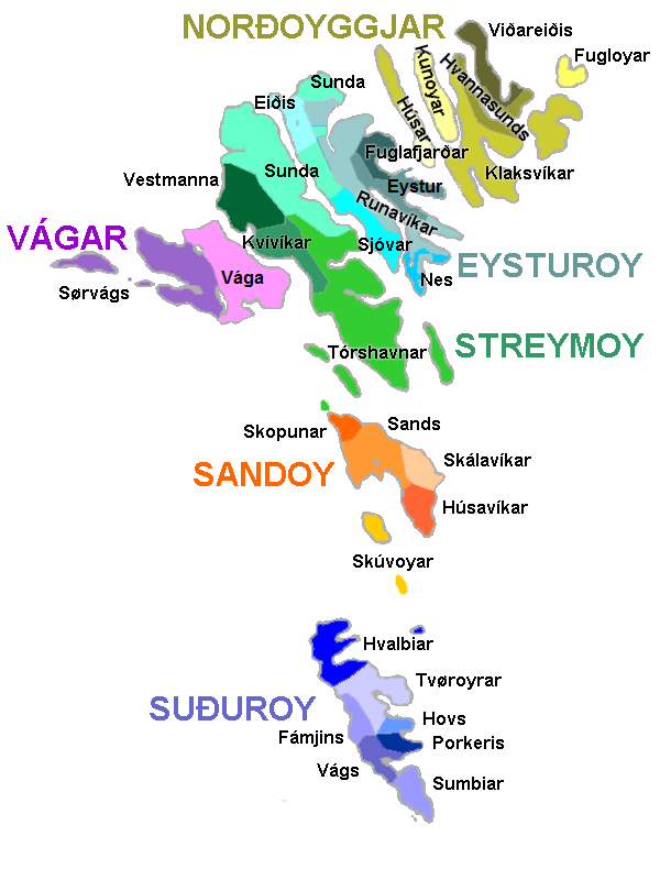
English: Map of the municipalities of the Faroe Islands, as of January 1, 2009.
Norsk bokmål: Kart over kommunene på Færøyene av 1. januar 2009.
Føroyskt: Kort yvir kommununum í Føroyum síðan 1. januar 2009. |
| Dato | |
| Kilde | Eget arbejde |
| Forfatter | Erik Fløan |
| Andre versioner | 2005 edition |
Licensering
| Jeg, indehaveren af ophavsretten til dette værk, udgiver dette værk som offentlig ejendom. Dette gælder i hele verden. I nogle lande er dette ikke juridisk muligt. I så fald: Jeg giver enhver ret til at anvende dette værk til ethvert formål, uden nogen restriktioner, medmindre sådanne restriktioner er påkrævede ved lov. |
Filhistorik
Klik på en dato/tid for at se filen som den så ud på det tidspunkt.
| Dato/tid | Miniaturebillede | Dimensioner | Bruger | Kommentar | |
|---|---|---|---|---|---|
| nuværende | 6. jan. 2009, 18:44 | | 600 × 800 (57 KB) | Efloean | {{Information |Description={{en|1=Map of the municipalities of the Faroe Islands, as of January 1, 2009.}} {{no|1=Kart over kommunene på Færøyene av 1. januar 2009.}} {{fo|1=Kort yvir kommununum í Føroyum síðan 1. januar 2009.}} |Source=Own work |A |
| 6. jan. 2009, 18:39 |  | 600 × 800 (57 KB) | Efloean | {{Information |Description={{en|1=Map of the municipalities of the Faroe Islands, as of January 1, 2009.}} {{no|1=Kart over kommunene på Færøyene av 1. januar 2009.}} {{fo|1=Kort yvir kommunur Føroya síðan 1. januar 2009.}} |Source=Own work |Author= |
Filanvendelse
De følgende 4 sider bruger denne fil:
Global filanvendelse
Følgende andre wikier anvender denne fil:
- Anvendelser på de.wikipedia.org
- Anvendelser på en.wikipedia.org
- Anvendelser på en.wiktionary.org
- Anvendelser på eu.wikipedia.org
- Anvendelser på fi.wikipedia.org
- Anvendelser på fr.wikipedia.org
- Anvendelser på hu.wikipedia.org
- Anvendelser på lt.wikipedia.org
- Anvendelser på no.wikipedia.org
- Anvendelser på pl.wikipedia.org
- Portal:Wyspy Owcze/Podział administracyjny
- Portal:Wyspy Owcze/Brudnopis
- Gminy Wysp Owczych
- Szablon:Gminy Wysp Owczych
- Thorshavn (gmina)
- Klaksvík (gmina)
- Eiði (gmina)
- Gøtu kommuna
- Tvøroyri (gmina)
- Kunoy (gmina)
- Runavík (gmina)
- Fuglafjørður (gmina)
- Fámjin (gmina)
- Fugloy (gmina)
- Funnings kommuna
- Leirvíkar kommuna
- Sørvágur (gmina)
Vis flere globale anvendelser af denne fil.