
Fil:USA Territorial Growth small.gif
Der findes ingen højere opløsning af billedet
USA_Territorial_Growth_small.gif (431 × 287 billedpunkter, filstørrelse: 456 KB, MIME-type: image/gif, gentaget, 10 rammer, 30 s)
|
|
Denne fil er fra Wikimedia Commons. Beskrivelsen af filen fra Commons er gengivet nedenfor. |

|
Denne fil er blevet afløst af File:USA territorial growth.gif, og du bør derfor oftest benytte den anden fil i stedet. Denne fil vil dog ikke blive slettet, medmindre den udtrykkeligt bliver nomineret til sletning.
|

|
Beskrivelse
| Beskrivelse |
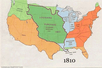
English: US territorial growth 1810–1920, based on the PD USGS maps in Category:Territorial growth maps of the United States.
See key below for explanation of colors.  |
||||||
| Kilde |
|
||||||
| Forfatter |
|
||||||
| Andre versioner |
|
Licensering
This image is in the public domain in the United States because it only contains materials that originally came from the United States Geological Survey, an agency of the United States Department of the Interior. For more information, see the official USGS copyright policy.
|
Filhistorik
Klik på en dato/tid for at se filen som den så ud på det tidspunkt.
| Dato/tid | Miniaturebillede | Dimensioner | Bruger | Kommentar | |
|---|---|---|---|---|---|
| nuværende | 30. maj 2006, 12:50 | | 431 × 287 (456 KB) | Roke~commonswiki | US territorial growth, based on the PD USGS maps in Category:USA Territorial Growth Maps Category: USA Territorial Growth Maps {{PD-USGov-USGS}} |
Filanvendelse
Den følgende side bruger denne fil:
Global filanvendelse
Følgende andre wikier anvender denne fil:
- Anvendelser på ar.wikipedia.org
- Anvendelser på be-tarask.wikipedia.org
- Anvendelser på be.wikipedia.org
- Anvendelser på ca.wikipedia.org
- Anvendelser på ckb.wikipedia.org
- Anvendelser på fr.wikipedia.org
- Anvendelser på fy.wikipedia.org
- Anvendelser på gcr.wikipedia.org
- Anvendelser på hr.wikipedia.org
- Anvendelser på id.wikipedia.org
- Anvendelser på it.wikipedia.org
- Anvendelser på jv.wikipedia.org
- Anvendelser på kk.wikipedia.org
- Anvendelser på ro.wikipedia.org
- Anvendelser på sh.wikipedia.org
- Anvendelser på sl.wikipedia.org
- Anvendelser på sr.wikipedia.org
- Anvendelser på tr.wikipedia.org
- Anvendelser på uk.wikipedia.org