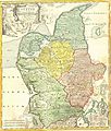
Fil:1710 Homann Map of Denmark "Iutiae" - Geographicus - Iutiae-homann-1710.jpg

Page contents not supported in other languages.
Fra Wikipedia, den frie encyklopædi

Fuld opløsning(2.500 × 2.935 billedpunkter, filstørrelse: 2,42 MB, MIME-type: image/jpeg)


Denne fil er fra Wikimedia Commons

Johann Baptist Homann: Tabula Generalis Iutiae   (Wikidata search (Cirrus search) Wikidata query (SPARQL)  Create new Wikidata item based on this file)
Kunstner
Johann Baptist Homann  (1664–1724)  wikidata:Q62706
 
Johann Baptist Homann
Alternative navne
Johann Baptist Homann; Ioannis Baptista Homann; Johann-Baptista Homann; Johann Baptista Homann
Beskrivelse tysk kartograf, udgiver og kobberstikker
Fødsels- og dødsdato 20. marts 1664 Edit this at Wikidata 1. juli 1724 Edit this at Wikidata
Fødsels- og dødssted Kammlach Nürnberg
Arbejdssted
Autoritetsdata
artist QS:P170,Q62706
Titel
Tabula Generalis Iutiae
Beskrivelse
English: This is a historically important and spectacular 1710 Homann map part of Denmark. Formally titled Tabula Generalis Iutiae. Features a decorative title cartouche including Poseidon and others. Johann Baptist Homann (1663-1724), his son, Christoph Homann (1703-30) founded 18th century's most important German cartography firm around 1702 in Nurnburg. Six years after his father's 1724 death, Christoph retired from the map business on the condition that all future maps produced by the firm be published under the name of Homann Heirs.
Dato 1710
date QS:P571,+1710-00-00T00:00:00Z/9
Mål højde: 20 in (50,8 cm); bredde: 23 in (58,4 cm)
dimensions QS:P2048,20U218593
dimensions QS:P2049,23U218593
Museumsnummer
Geographicus link: Iutiae-homann-1710
Kilde/Fotograf
Tilladelse
(Genbrug af denne fil)
Dette er en troværdig, fotografisk gengivelse af et originalt todimensionelt kunstværk. Kopier af kunstværket er offentlig ejendom af følgende grund:
Public domain

Værket er også offentlig ejendom i lande og områder, hvor ophavsrettens længde er ophavsmandens levetid plus 100 år eller derunder.


Denne skabelon skal kombineres med en licensskabelon for USA, der angiver hvorfor dette værk er offentlig ejendom i USA.
Den officielle holdning, som Wikimedia Foundation følger er, at "faithful reproductions of two-dimensional public domain works of art are public domain, and that claims to the contrary represent an assault on the very concept of a public domain". For yderligere oplysninger, se Commons:When to use the PD-Art tag.
Denne fotografiske gengivelse betragtes derfor også som værende offentlig ejendom Vær opmærksom på, at, afhængig af lokale love, kan brug af dette indhold forbydes eller begrænses i dit område. Se Commons:Reuse of PD-Art photographs.

Captions

Tilføj en kort forklaring på en enkelt linje om hvad filen viser

Elementer som er med i denne fil

afbilder

image/jpeg

8e4b9f1a2036dba4816a2399967ad36eadc797e7

2.540.253 Byte

2.935 pixel

2.500 pixel

Filhistorik

Klik på en dato/tid for at se filen som den så ud på det tidspunkt.

Dato/tidMiniaturebilledeDimensionerBrugerKommentar
nuværende24. mar. 2011, 21:01Miniature af versionen fra 24. mar. 2011, 21:012.500 × 2.935 (2,42 MB)BotMultichillT{{subst:User:Multichill/Geographicus |link=http://www.geographicus.com/P/AntiqueMap/Iutiae-homann-1710 |product_name=1710 Homann Map of Denmark "Iutiae" |map_title=Tabula Generalis Iutiae |description=This is a historically important and spectacular 1710

Den følgende side bruger denne fil:

Global filanvendelse

Følgende andre wikier anvender denne fil: