
Fil:Average precipitation in the lower 48 states of the USA.png

Størrelse af denne forhåndsvisning: 800 × 538 pixels. Andre opløsninger: 320 × 215 pixels | 640 × 430 pixels | 1.024 × 689 pixels | 1.280 × 861 pixels | 2.785 × 1.873 pixels.
Fuld opløsning (2.785 × 1.873 billedpunkter, filstørrelse: 2,19 MB, MIME-type: image/png)
|
|
Denne fil er fra Wikimedia Commons. Beskrivelsen af filen fra Commons er gengivet nedenfor. |
Beskrivelse
| Beskrivelse |
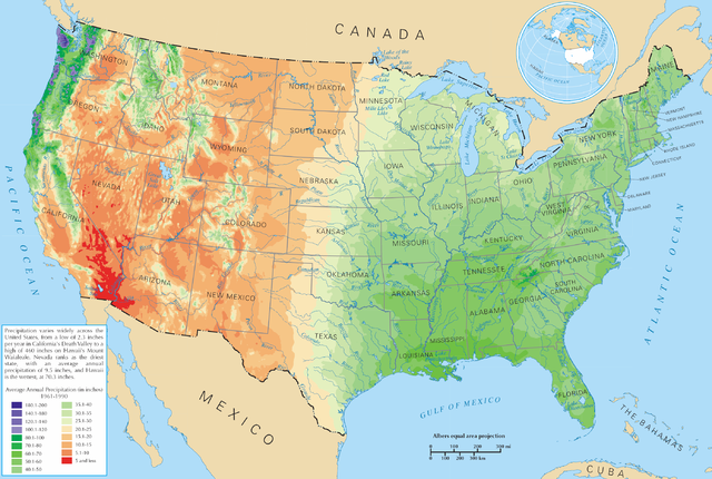
English: Average precipitation in the lower 48 states of the United States of America.
Español: Promedio de la precipitación de los 48 estados contiguos |
| Kilde | https://nationalmap.gov/small_scale/printable/climatemap.html |
| Forfatter | United States Department of the Interior |
Licensering
This map was obtained from an edition of the National Atlas of the United States. Like almost all works of the U.S. federal government, works from the National Atlas are in the public domain in the United States.
Online access: NationalAtlas.gov | 1970 print edition: Library of Congress, Perry-Castañeda Library
|
Filhistorik
Klik på en dato/tid for at se filen som den så ud på det tidspunkt.
| Dato/tid | Miniaturebillede | Dimensioner | Bruger | Kommentar | |
|---|---|---|---|---|---|
| nuværende | 28. mar. 2006, 23:08 | | 2.785 × 1.873 (2,19 MB) | Tom | ==Description== Average precipitation in the lower 48 states of the United States of America. ==License== {{PD-USGov-Atlas}} |
Filanvendelse
Den følgende side bruger denne fil:
Global filanvendelse
Følgende andre wikier anvender denne fil:
- Anvendelser på bg.wikipedia.org
- Anvendelser på cs.wikipedia.org
- Anvendelser på de.wikipedia.org
- Anvendelser på en.wikipedia.org
- Anvendelser på fr.wikipedia.org
- Anvendelser på hak.wikipedia.org
- Anvendelser på he.wikipedia.org
- Anvendelser på ht.wikipedia.org
- Anvendelser på hu.wikipedia.org
- Anvendelser på hy.wikipedia.org
- Anvendelser på id.wikipedia.org
- Anvendelser på ja.wikipedia.org
- Anvendelser på lg.wikipedia.org
- Anvendelser på mg.wikipedia.org
- Anvendelser på pcd.wikipedia.org
- Anvendelser på pl.wikipedia.org
- Anvendelser på pl.wiktionary.org
- Stany Zjednoczone
- Съединени щати
- Съединени американски щати
- Bandaríkin
- Bandaríki Norður-Ameríku
- Amerikan yhdysvallat
- Amerikka
- United States of America
- United States
- U.S.A.
- U.S.
- Stany Zjednoczone Ameryki
- Egyesült Államok
- Amerikai Egyesült Államok
- الولايات المتحدة
- Злучаныя Штаты Амерыкі
- fenua Marite
- ᐊᒥᐊᓕᑲ
- Amerikas förenta stater
- الولايات المتحدة الأمريكية
- Amerika Birləşmiş Ştatları
- Ameriketako Estatu Batuak
- Mokuʻāina-hui-ʻia
- АҚШ
Vis flere globale anvendelser af denne fil.