
Fil:Aerial photograph of Midway Atoll on 24 November 1941 (80-G-451086).jpg

Størrelse af denne forhåndsvisning: 792 × 600 pixels. Andre opløsninger: 317 × 240 pixels | 634 × 480 pixels | 1.014 × 768 pixels | 1.280 × 969 pixels | 2.560 × 1.939 pixels | 4.526 × 3.428 pixels.
Fuld opløsning (4.526 × 3.428 billedpunkter, filstørrelse: 6,09 MB, MIME-type: image/jpeg)
|
|
Denne fil er fra Wikimedia Commons. Beskrivelsen af filen fra Commons er gengivet nedenfor. |
.jpg?uselang=da)
Beskrivelse
| Fotograf |
Ukendt |
||||||||||||||||||||
| Beskrivelse |
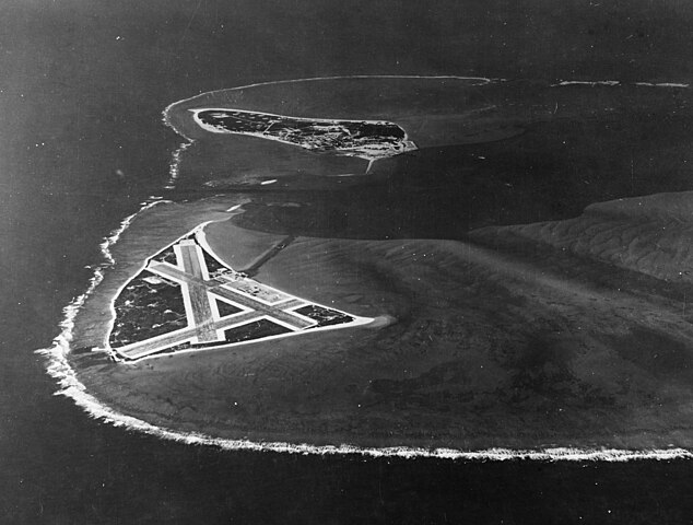
English: Aerial photograph of Midway Atoll, looking just south of west across the southern side of the atoll, 24 November 1941. Eastern Island, then the site of Midway's airfield, is in the foreground. Sand Island, location of most other base facilities, is across the entrance channel. |
||||||||||||||||||||
| Depicted place | Midway Atoll | ||||||||||||||||||||
| Dato | 24. november 1941 | ||||||||||||||||||||
| Samling |
|
||||||||||||||||||||
| Museumsnummer |
80-G-451086 |
||||||||||||||||||||
| Kilde | U.S. Navy photo 80-G-451086 | ||||||||||||||||||||
| Andre versioner | File:Aerial view of Midway Atoll on 24 November 1941 (80-G-451086).jpg | ||||||||||||||||||||
.jpg)
Licensering
| This image is available from the Naval History and Heritage Command under the digital ID 80-G-451086. Most of the photos found in the NHHC collection are in the public domain and may be downloaded and used without permissions or special requirements. Those which are not will be noted in the copyright section of the NHHC image description.[1] |
This file is a work of a sailor or employee of the U.S. Navy, taken or made as part of that person's official duties. As a work of the U.S. federal government, it is in the public domain in the United States.
|
 | |
| Denne fil er blevet identificeret som værende fri for kendte restriktioner under lov om ophavsret, herunder alle relaterede og tilstødende rettigheder. | ||
Filhistorik
Klik på en dato/tid for at se filen som den så ud på det tidspunkt.
| Dato/tid | Miniaturebillede | Dimensioner | Bruger | Kommentar | |
|---|---|---|---|---|---|
| nuværende | 28. okt. 2015, 23:42 | | 4.526 × 3.428 (6,09 MB) | Cobatfor | new NHHC file |
| 9. feb. 2012, 23:58 |  | 680 × 740 (333 KB) | Cobatfor | caption bar cropped | |
| 22. maj 2006, 15:21 |  | 680 × 765 (127 KB) | Ulflarsen | Caption: Midway Atoll. Aerial photograph, looking just south of west across the southern side of the atoll, 24 November 1941. Eastern Island, then the site of Midway's airfield, is in the foreground. Sand Island, location of most other base facilities, is |
Filanvendelse
Den følgende side bruger denne fil:
Global filanvendelse
Følgende andre wikier anvender denne fil:
- Anvendelser på el.wikipedia.org
- Anvendelser på it.wikipedia.org
- Anvendelser på nl.wikipedia.org
- Anvendelser på pl.wikipedia.org
.jpg)