
Fil:Korean war 1950-1953.gif
Størrelse af denne forhåndsvisning: 387 × 600 pixels. Andre opløsninger: 155 × 240 pixels | 562 × 871 pixels.
Fuld opløsning (562 × 871 billedpunkter, filstørrelse: 1,32 MB, MIME-type: image/gif, gentaget, 20 rammer, 30 s)
|
|
Denne fil er fra Wikimedia Commons. Beskrivelsen af filen fra Commons er gengivet nedenfor. |

Beskrivelse
| Beskrivelse |
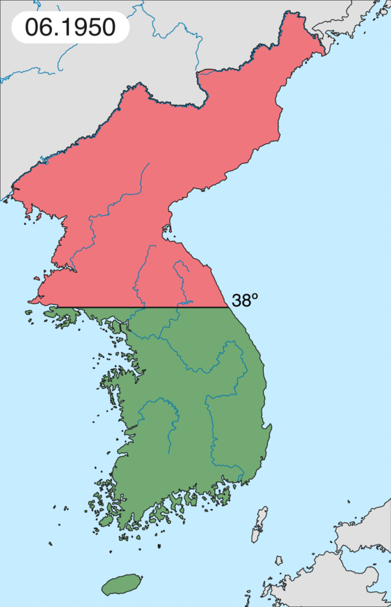
English: Map of Korean war from May 1950 to July 1951, showing:
Français : Carte de la guerre de Corée de mai 1950 à juillet 1951, montrant:
Deutsch: Karte des Koreakriegs von Mai 1950 bis Juli 1951, abgebildet:
Italiano: Mappa della guerra di Corea dal maggio 1950 al luglio 1951, rappresentante:
|
| Dato | |
| Kilde | Eget arbejde |
| Forfatter | Leomonaci98 |
Licensering
Jeg, dette værks ophavsretsindehaver, udgiver hermed værket under den følgende licens:

|
Tilladelse er givet til at kopiere, distribuere og/eller ændre dette dokument under betingelserne i GNU Free Documentation License', Version 1.2 eller enhver senere version udgivet af Free Software Foundation; uden et invariant afsnit, ingen forsidetekster, og ingen bagsidetekst. En kopi af licensen er inkluderet i afsnittet GNU Free Documentation License. |
| Denne fil er udgivet under Creative Commons Kreditering-Del på samme vilkår 3.0 Ikke-porteret-licensen. | ||
| ||
| Denne licens blev tilføjet som en del af GFDL-licensopdateringen. |
Du kan vælge den licens du foretrækker.
Filhistorik
Klik på en dato/tid for at se filen som den så ud på det tidspunkt.
| Dato/tid | Miniaturebillede | Dimensioner | Bruger | Kommentar | |
|---|---|---|---|---|---|
| nuværende | 16. feb. 2020, 22:20 | | 562 × 871 (1,32 MB) | Leomonaci98 | Graphic update |
| 1. maj 2013, 03:02 |  | 227 × 400 (85 KB) | Spesh531 | update for every month | |
| 9. jun. 2006, 10:47 |  | 227 × 400 (37 KB) | Roke~commonswiki | rm white | |
| 8. jun. 2006, 08:25 |  | 227 × 400 (37 KB) | Roke~commonswiki | add OngJin peninsula after comment, also blank frame at end | |
| 5. jun. 2006, 17:14 |  | 227 × 400 (37 KB) | Roke~commonswiki | Korean war, showing North Korean, Chinese and communist forces (red); South Korean, US and United Nations forces (green). Category: Korean War Category: Animated maps |
Filanvendelse
Den følgende side bruger denne fil:
Global filanvendelse
Følgende andre wikier anvender denne fil:
- Anvendelser på af.wikipedia.org
- Anvendelser på az.wikipedia.org
- Anvendelser på bat-smg.wikipedia.org
- Anvendelser på bg.wikipedia.org
- Anvendelser på br.wikipedia.org
- Anvendelser på bs.wikipedia.org
- Anvendelser på ca.wikipedia.org
- Corea del Nord
- Corea del Sud
- Ióssif Stalin
- Mao Zedong
- Winston Churchill
- Harry Truman
- Guerra de Corea
- Kim Il-sung
- Viatxeslav Mólotov
- Gueorgui Malenkov
- Douglas MacArthur
- Lavrenti Béria
- M*A*S*H (pel·lícula)
- Clement Attlee
- Mark Wayne Clark
- Zona desmilitaritzada de Corea
- República Popular d'Hongria
- Syngman Rhee
- Peng Dehuai
- Força Aèria de l'Exèrcit Popular de Corea
- Forces Armades de Corea del Nord
- Forces Armades de la República de Corea
- 65è Regiment d'Infanteria (Estats Units)
- Frontera entre Corea del Nord i Corea del Sud
- Kim Chaek
- Batalla d'Inchon
- Plantilla:Guerra de Corea
- Pak Hon-yong
- Anvendelser på ckb.wikipedia.org
- Anvendelser på cs.wikipedia.org
- Anvendelser på cy.wikipedia.org
- Anvendelser på de.wikipedia.org
- Anvendelser på el.wikipedia.org
- Anvendelser på en.wikipedia.org
Vis flere globale anvendelser af denne fil.