
Fil:LondonLambeth.png
Der findes ingen højere opløsning af billedet
LondonLambeth.png (200 × 155 billedpunkter, filstørrelse: 23 KB, MIME-type: image/png)
|
|
Denne fil er fra Wikimedia Commons. Beskrivelsen af filen fra Commons er gengivet nedenfor. |
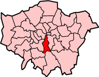
London Borough of Lambeth
Map drawn by en:User:Morwen

|
Tilladelse er givet til at kopiere, distribuere og/eller ændre dette dokument under betingelserne i GNU Free Documentation License', Version 1.2 eller enhver senere version udgivet af Free Software Foundation; uden et invariant afsnit, ingen forsidetekster, og ingen bagsidetekst. En kopi af licensen er inkluderet i afsnittet GNU Free Documentation License. |
| Denne fil er udgivet under Creative Commons Kreditering-Del på samme vilkår 3.0 Ikke-porteret-licensen. | ||
| ||
| Denne licens blev tilføjet som en del af GFDL-licensopdateringen. |
Filhistorik
Klik på en dato/tid for at se filen som den så ud på det tidspunkt.
| Dato/tid | Miniaturebillede | Dimensioner | Bruger | Kommentar | |
|---|---|---|---|---|---|
| nuværende | 9. apr. 2005, 12:04 | | 200 × 155 (23 KB) | Voyager | London Borough of Lambeth Map drawn by en:User:Morwen {{GFDL}} Category:Maps of London |
Filanvendelse
Den følgende side bruger denne fil:
Global filanvendelse
Følgende andre wikier anvender denne fil:
- Anvendelser på en.wikipedia.org
- London Eye
- Balham
- Brixton
- Clapham
- Crystal Palace, London
- Kennington
- Stockwell
- Streatham
- Tulse Hill
- Vauxhall
- London Borough of Lambeth
- Royal National Theatre
- West Norwood
- South Bank
- South London Theatre
- Clapham Park
- Lambeth
- Upper Norwood
- Lambeth Palace
- The Oval
- Royal Festival Hall
- Herne Hill
- Brockwell Park
- Oval, London
- Herne Hill railway station
- Kennington Park
- Southbank Centre
- Queen Elizabeth Hall
- Norbury
- Purcell Room
- Jubilee Gardens, Lambeth
- Gipsy Hill
- Ovalhouse
- Lower Marsh
- West Dulwich
- Norwood Park (London)
- Waterloo, London
- Loughborough Junction
- Knight's Hill, West Norwood
- Template:LB Lambeth
- Little Portugal, London
- Lambeth Marsh
- Category:London Borough of Lambeth
- List of public art in the London Borough of Lambeth
- Myatt's Fields Park
- List of people from the London Borough of Lambeth
- BFI Southbank
- Ruskin Park
- Grade I and II* listed buildings in the London Borough of Lambeth
- Vauxhall City Farm
Vis flere globale anvendelser af denne fil.