
Fil:Map of Glacier National Park.PNG

Størrelse af denne forhåndsvisning: 527 × 600 pixels. Andre opløsninger: 211 × 240 pixels | 422 × 480 pixels | 675 × 768 pixels | 900 × 1.024 pixels | 1.657 × 1.885 pixels.
Fuld opløsning (1.657 × 1.885 billedpunkter, filstørrelse: 2,44 MB, MIME-type: image/png)
|
|
Denne fil er fra Wikimedia Commons. Beskrivelsen af filen fra Commons er gengivet nedenfor. |
Beskrivelse
| Beskrivelse |
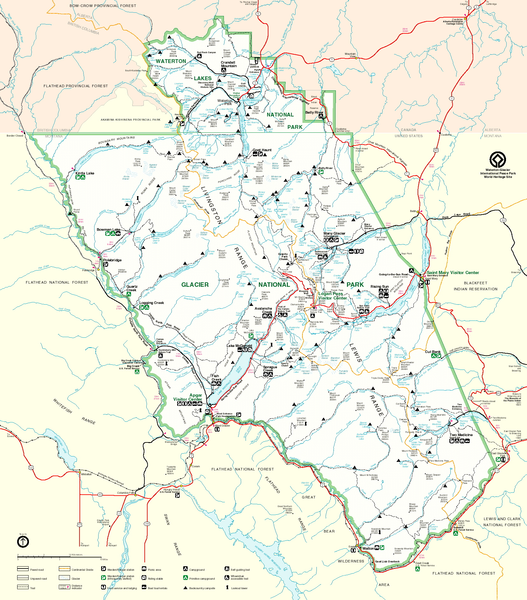
English: Map of Glacier National Park, Montana, USA and Waterton Lakes National Park, Alberta, Canada |
| Kilde | http://www.nps.gov/glac/images/bigmap.gif |
| Forfatter | US-NPS |
Licensering
| This image or media file contains material based on a work of a National Park Service employee, created as part of that person's official duties. As a work of the U.S. federal government, such work is in the public domain in the United States. See the NPS website and NPS copyright policy for more information. |
Filhistorik
Klik på en dato/tid for at se filen som den så ud på det tidspunkt.
| Dato/tid | Miniaturebillede | Dimensioner | Bruger | Kommentar | |
|---|---|---|---|---|---|
| nuværende | 13. maj 2006, 13:01 | | 1.657 × 1.885 (2,44 MB) | MONGO | {{Information| |Description=Map of Glacier National Park |Source=http://www.nps.gov/glac/images/bigmap.gif |Date= |Author= |Permission= |other_versions= }} |
Filanvendelse
Den følgende side bruger denne fil:
Global filanvendelse
Følgende andre wikier anvender denne fil:
- Anvendelser på ar.wikipedia.org
- Anvendelser på ca.wikipedia.org
- Anvendelser på en.wikipedia.org
- Anvendelser på es.wikipedia.org
- Anvendelser på eu.wikipedia.org
- Anvendelser på fr.wikipedia.org
- Anvendelser på he.wikipedia.org
- Anvendelser på hy.wikipedia.org
- Anvendelser på it.wikipedia.org
- Anvendelser på no.wikipedia.org
- Anvendelser på pl.wikipedia.org
- Anvendelser på ru.wikipedia.org
- Anvendelser på tr.wikipedia.org
- Anvendelser på uk.wikipedia.org
- Anvendelser på vi.wikipedia.org