
Fil:Map of USA AK full.png
Der findes ingen højere opløsning af billedet
Map_of_USA_AK_full.png (284 × 184 billedpunkter, filstørrelse: 19 KB, MIME-type: image/png)
|
|
Denne fil er fra Wikimedia Commons. Beskrivelsen af filen fra Commons er gengivet nedenfor. |

|
En vektorversion af dette billede (SVG) er tilgængelig. Det bør bruges i stedet for punktgrafikbilledet når det er fordelagtigt.
File:Map of USA AK full.png → File:Map of USA AK full.svg
For mere information om vektorgrafik: Læs om overgangen til SVG på Commons. Se også information om MediaWikis understøttelse af SVG-billeder. |
 |
Beskrivelse
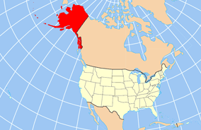
| Beskrivelse | Map of USA with Alaska highlighted and shown in true position |
| Dato | |
| Kilde | http://www.nationalatlas.gov/printable/reference.html |
| Forfatter | |
| Andre versioner | File:Map of USA AK full.svg |
Licensering
This map was obtained from an edition of the National Atlas of the United States. Like almost all works of the U.S. federal government, works from the National Atlas are in the public domain in the United States.
Online access: NationalAtlas.gov | 1970 print edition: Library of Congress, Perry-Castañeda Library
|
Filhistorik
Klik på en dato/tid for at se filen som den så ud på det tidspunkt.
| Dato/tid | Miniaturebillede | Dimensioner | Bruger | Kommentar | |
|---|---|---|---|---|---|
| nuværende | 17. dec. 2012, 22:43 | | 284 × 184 (19 KB) | Ras67 | cropped |
| 2. apr. 2007, 18:31 |  | 286 × 186 (20 KB) | MattWright | fix to more standard map colors | |
| 2. apr. 2007, 08:20 |  | 286 × 186 (19 KB) | MattWright | {{Information |Description=Map of USA with Alaska highlighted and shown in true position |Source=http://www.nationalatlas.gov/printable/reference.html |Date=2007-04-02 |Author= |Permission= |other_versions= }} Category:Maps of the United States [[Cat |
Filanvendelse
De følgende 8 sider bruger denne fil:
Global filanvendelse
Følgende andre wikier anvender denne fil:
- Anvendelser på am.wikipedia.org
- Anvendelser på ar.wikipedia.org
- Anvendelser på az.wikipedia.org
- Anvendelser på az.wiktionary.org
- Anvendelser på ba.wikipedia.org
- Anvendelser på bn.wikipedia.org
- Anvendelser på ce.wikipedia.org
- Anvendelser på cy.wikipedia.org
- Anvendelser på de.wikipedia.org
- Anvendelser på el.wikipedia.org
- Anvendelser på en.wikipedia.org
- Anvendelser på es.wikibooks.org
- Anvendelser på fa.wikipedia.org
- Anvendelser på fr.wikinews.org
- Anvendelser på ga.wikipedia.org
- Sitka
- Buirg Aleutians Thoir, Alasca
- Buirg Anchorage, Alasca
- Buirg Artach Thiar Thuaidh, Alasca
- Buirg Bristol Bay, Alasca
- Buirg Denali, Alasca
- Buirg Fairbanks Réalta Thuaidh, Alasca
- Buirg Haines, Alasca
- Buirg Juneau, Alasca
- Buirg Leithinis Kenai, Alasca
- Buirg Tairseach Ketchikan, Alasca
- Buirg Oileán Kodiak, Alasca
- Buirg Loch agus Leithinis, Alasca
- Buirg Matanuska-Susitna, Alasca
- Buirg Fána Taobh Thuaidh, Alasca
- Buirg Petersburg, Alasca
- Buirg Sitka, Alasca
- Buirg Skagway, Alasca
- Buirg Wrangell, Alasca
- Buirg Yakutat, Alasca
- Buirg Neamheagraithe, Alasca
- Anvendelser på he.wikipedia.org
Vis flere globale anvendelser af denne fil.