
Fil:Pacific Theater Areas;map1.JPG
Størrelse af denne forhåndsvisning: 800 × 582 pixels. Andre opløsninger: 320 × 233 pixels | 640 × 466 pixels | 1.024 × 746 pixels | 1.199 × 873 pixels.
Fuld opløsning (1.199 × 873 billedpunkter, filstørrelse: 351 KB, MIME-type: image/jpeg)
|
|
Denne fil er fra Wikimedia Commons. Beskrivelsen af filen fra Commons er gengivet nedenfor. |

|
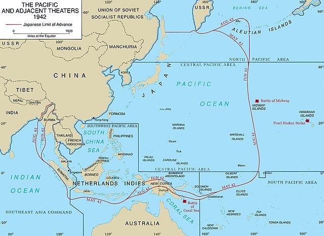
En vektorversion af dette billede (SVG) er tilgængelig. Det bør bruges i stedet for punktgrafikbilledet når det er fordelagtigt.
File:Pacific Theater Areas;map1.JPG → File:Pacific Theater Areas;map1.svg
For mere information om vektorgrafik: Læs om overgangen til SVG på Commons. Se også information om MediaWikis understøttelse af SVG-billeder. |
 |
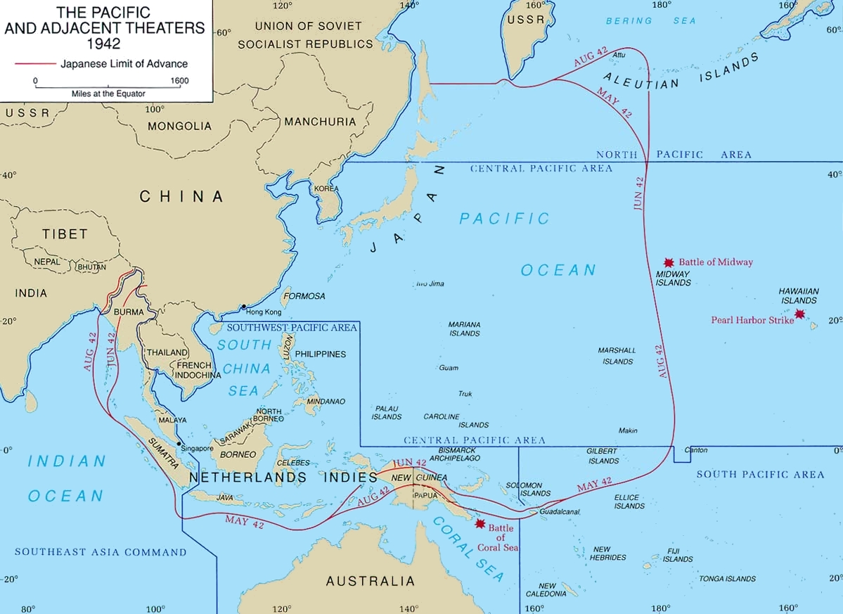
Map of Pacific theater of operations during World War II showing the boundaries of the Japanese Empire. Newell, Clayton R. (2003). Central Pacific. The US Army Campaigns of World War II. US Army Center of Military History. Archived from the original on 2012-02-02. Retrieved on 2008-08-06.
This file is a work of a U.S. Army soldier or employee, taken or made as part of that person's official duties. As a work of the U.S. federal government, it is in the public domain in the United States.
|
 |
Filhistorik
Klik på en dato/tid for at se filen som den så ud på det tidspunkt.
| Dato/tid | Miniaturebillede | Dimensioner | Bruger | Kommentar | |
|---|---|---|---|---|---|
| nuværende | 18. jan. 2018, 22:43 | | 1.199 × 873 (351 KB) | Hohum | Cleanup |
| 6. mar. 2005, 23:06 |  | 1.199 × 873 (142 KB) | Wwoods | Pacific_Theater_Areas; http://www.army.mil/cmh-pg/brochures/72-4/72-4.htm {{PD-USGov-Military-Army}} |
Filanvendelse
De følgende 3 sider bruger denne fil:
Global filanvendelse
Følgende andre wikier anvender denne fil:
- Anvendelser på br.wikipedia.org
- Anvendelser på ca.wikipedia.org
- Anvendelser på ch.wikipedia.org
- Anvendelser på de.wikipedia.org
- Anvendelser på en.wikipedia.org
- Guadalcanal campaign
- Asiatic-Pacific theater
- South West Pacific Area
- Pacific Ocean Areas
- Cactus Air Force
- Invasion of Tulagi (May 1942)
- Kawaguchi Detachment
- Portal:Maps/Some special maps/Military
- Portal:Maps/Some special maps/Military/1
- Portal:Maps/Military/1
- Joint Army–Navy Assessment Committee
- User:Telecineguy/sandbox
- Louis Edward Curdes
- Naval Base Iwo Jima
- Naval Base Gilbert Islands
- Naval Base Marshall Islands
- US Naval Base Australia
- US Naval Base New Guinea
- United States naval bases in the Philippines
- US Naval Base Solomons
- US Naval Base Carolines
- Naval Base Samoa
- Naval Base Borneo
- Anvendelser på en.wikibooks.org
- Anvendelser på es.wikipedia.org
- Anvendelser på eu.wikipedia.org
- Anvendelser på fa.wikipedia.org
- Anvendelser på fi.wikipedia.org
- Anvendelser på fr.wikipedia.org
- Anvendelser på he.wikipedia.org
- Anvendelser på hu.wikipedia.org
- Anvendelser på id.wikipedia.org
Vis flere globale anvendelser af denne fil.