
Fil:Ro-map.png
Der findes ingen højere opløsning af billedet
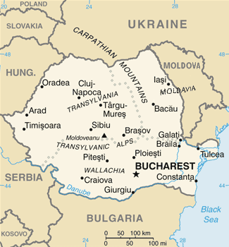
Ro-map.png (325 × 350 billedpunkter, filstørrelse: 21 KB, MIME-type: image/png)
|
|
Denne fil er fra Wikimedia Commons. Beskrivelsen af filen fra Commons er gengivet nedenfor. |
| Beskrivelse |
English: Map of Romania, as depicted in the 2004 edition of the CIA World Factbook (with the subsequent separation of Montenegro from Serbia in 2006, and marking Kosovo on the map). |
| Dato | |
| Kilde | The CIA World Factbook 2004 |
| Forfatter | The CIA World Factbook 2004 |
| Andre versioner |
|

.png)


This image is in the public domain because it contains materials that originally came from the United States Central Intelligence Agency's World Factbook.
|
 |
Filhistorik
Klik på en dato/tid for at se filen som den så ud på det tidspunkt.
| Dato/tid | Miniaturebillede | Dimensioner | Bruger | Kommentar | |
|---|---|---|---|---|---|
| nuværende | 30. okt. 2021, 19:13 | | 325 × 350 (21 KB) | Lojwe | Cropped 1 % horizontally, 1 % vertically using CropTool with precise mode. |
| 17. jun. 2017, 21:40 |  | 328 × 353 (24 KB) | Julieta39 | Cosmetic changes | |
| 21. apr. 2008, 12:58 |  | 328 × 353 (24 KB) | Olahus | ||
| 7. jul. 2006, 05:13 |  | 326 × 350 (15 KB) | Cantus | ||
| 5. mar. 2005, 00:59 |  | 316 × 339 (13 KB) | Alfio | CIA map of Romania |
Filanvendelse
Der er ingen sider der bruger denne fil.
Global filanvendelse
Følgende andre wikier anvender denne fil:
- Anvendelser på ba.wikipedia.org
- Anvendelser på be-tarask.wikipedia.org
- Anvendelser på bg.wikipedia.org
- Anvendelser på de.wikipedia.org
- Anvendelser på el.wikipedia.org
- Anvendelser på en.wikipedia.org
- Anvendelser på es.wikipedia.org
- Anvendelser på fi.wikivoyage.org
- Anvendelser på fr.wikipedia.org
- Anvendelser på gl.wikipedia.org
- Anvendelser på hu.wikipedia.org
- Anvendelser på hy.wikipedia.org
- Anvendelser på hyw.wikipedia.org
- Anvendelser på ig.wikipedia.org
- Anvendelser på io.wikipedia.org
- Anvendelser på is.wikipedia.org
- Anvendelser på it.wikipedia.org
- Anvendelser på it.wikinews.org
- Anvendelser på ja.wikipedia.org
- Anvendelser på lt.wiktionary.org
- Anvendelser på mn.wikipedia.org
- Anvendelser på mr.wikipedia.org
- Anvendelser på nl.wiktionary.org
- Anvendelser på no.wikipedia.org
- Anvendelser på pt.wikipedia.org
- Anvendelser på pt.wikivoyage.org
- Anvendelser på roa-tara.wikipedia.org
- Anvendelser på ru.wikipedia.org
- Anvendelser på sk.wikipedia.org
- Anvendelser på sq.wikipedia.org
- Anvendelser på tr.wiktionary.org
- Anvendelser på udm.wikipedia.org
- Anvendelser på vo.wikipedia.org
- Anvendelser på zh.wikipedia.org