
Fil:Tectonic plate boundaries.png
Der findes ingen højere opløsning af billedet
Tectonic_plate_boundaries.png (775 × 429 billedpunkter, filstørrelse: 83 KB, MIME-type: image/png)
|
|
Denne fil er fra Wikimedia Commons. Beskrivelsen af filen fra Commons er gengivet nedenfor. |
Beskrivelse
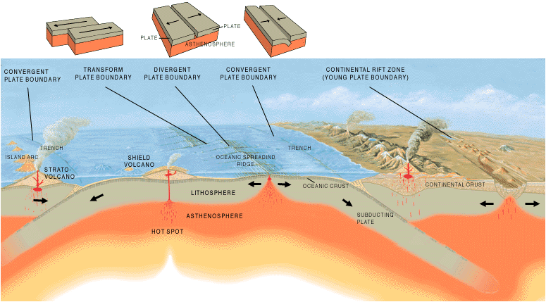
| Beskrivelse | A cross section illustrating the main types of plate boundaries. |
| Dato | |
| Kilde | [1] |
| Forfatter | Jose F. Vigil. USGS |
| Andre versioner |
Slovenian translation, Spanish version
[]
|


Licensering
This image is in the public domain in the United States because it only contains materials that originally came from the United States Geological Survey, an agency of the United States Department of the Interior. For more information, see the official USGS copyright policy.
|
Filhistorik
Klik på en dato/tid for at se filen som den så ud på det tidspunkt.
| Dato/tid | Miniaturebillede | Dimensioner | Bruger | Kommentar | |
|---|---|---|---|---|---|
| nuværende | 26. dec. 2005, 17:40 | | 775 × 429 (83 KB) | Merikanto~commonswiki | Illustration by Jose F. Vigil. USGS. [http://pubs.usgs.gov/gip/earthq1/plate.html] {{PD-USGov-Interior-USGS}} |
Filanvendelse
De følgende 2 sider bruger denne fil:
Global filanvendelse
Følgende andre wikier anvender denne fil:
- Anvendelser på ar.wikipedia.org
- Anvendelser på as.wikipedia.org
- Anvendelser på az.wikipedia.org
- Anvendelser på ba.wikipedia.org
- Anvendelser på bg.wikipedia.org
- Anvendelser på bs.wikipedia.org
- Anvendelser på de.wikipedia.org
- Anvendelser på en.wikipedia.org
- Anvendelser på en.wikibooks.org
- Anvendelser på eo.wikipedia.org
- Anvendelser på es.wikipedia.org
- Anvendelser på eu.wikipedia.org
- Anvendelser på fa.wikipedia.org
- Anvendelser på fi.wikipedia.org
- Anvendelser på fr.wikipedia.org
- Anvendelser på ga.wikipedia.org
- Anvendelser på he.wikipedia.org
- Anvendelser på hi.wikipedia.org
- Anvendelser på hu.wikipedia.org
- Anvendelser på hy.wikipedia.org
- Anvendelser på hyw.wikipedia.org
- Anvendelser på id.wikipedia.org
- Anvendelser på it.wikipedia.org
- Anvendelser på it.wikibooks.org
- Anvendelser på it.wikiversity.org
- Anvendelser på ja.wikipedia.org
- Anvendelser på ka.wikipedia.org
- Anvendelser på kn.wikipedia.org
- Anvendelser på ko.wikipedia.org
Vis flere globale anvendelser af denne fil.