
Bruger:LinguineFusilli/sandkasse20
| Helsinki Metro Finsk: Helsingin metro Svensk: Helsingfors metro | |
|---|---|
|
| |
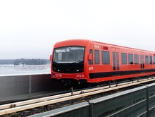 M300-tog i 2017 | |
| Overblik | |
| Type | Undergrundsbane |
| Lokalitet | Hovedstadsregionen, Finland |
| Antal stationer |
25[3] Yderligere 5 under opførelse[3] |
| Antal linjer | 2[3] |
| Dagligt passagertal |
304.000 (dagligt, 2017)[1] 62.8 mio. (årligt, 2015)[2] |
| Drift | |
| Åbnet | 2. august 1982[4] |
| Operatør(er) | HKL |
| Teknisk | |
| Strækningslængde | 35 km[5] |
| Sporvidde | 1522 mm[5] |
| Elektrificering | 750 V jævnstrøm[5] |
| Strækningshastighed | 80 km/t[5] |
Helsinki Metro (finsk: Helsingin metro, svensk: Helsingfors metro) er et metrosystem i Finlands Hovedstadsregion omkring Helsinki. Systemet blev åbnet den 2. august 1982[4] og råder i dag over 35 km spor med 2 linjer og 25 stationer, med yderligere 5 under opførelse.[5][3] Systemet fungerer som en forbindelse mellem forstæderne Vuosaari mod øst og Espoo mod vest til og fra hinanden og det centrale Helsinki. Metrosystemet er derudover verdens nordligste.[6]
Historie[redigér | rediger kildetekst]
1955–1967: Letbaneplan[redigér | rediger kildetekst]


Mørkeblå = spor over overfladen
Stiplet lyseblå = spor under overfladen
Digital rekonstruktion fra 2018.
Det originale forslag til at bygge et sporvejssystem i Hovedstadsregionen omkring Helsinki blev fremlagt i september 1955, selvom ideen om en ????????TUNNELLED urban jernbane havde været diskuteret flere gange over de tidligere fem årtier. En forstadstrafikkommission (finsk: esikaupunkiliikennekomitea) blev skabt under ingeniøren Reino Castréns ledelse, og i slutningen af 1955 begyndte kommissionen at undersøge, om der rent faktisk var behov for et ????????TUNNELLED offentligt transportsystem i Helsinki. Efter næsten fire års arbejde fremlagde kommissionen sine undersøgelse for byrådet. Undersøgelsernes resultater var klare: Helsinki havde brug for et metrosystem, som ikke var baseret på vejnetværket, da dette allerede var under øget pres grundet stigende ejerskab af privatbiler samt et offentligt transportnetværk, der voksede i takt med byens indbyggertal. Dette var første gang udtrykket "metro" blev brugt til at beskrive det planlagte transportsystem. Kommissionen uddybede endnu ikke, hvilke typer køretøjer, der skulle benyttes på metrosystemet; sporvogne, ??????tunge toge, busser og trolleybusser var alle muligheder og alternativer. Byrådets reaktion til kommissionens præsentation var meget apatisk, og flere byrådsmedlemmer udtalte til pressen, at de ikke forstod noget af Castréns og kommissionens præsentation.[7]
På trods af den kedelige reception blev Castréns kommission bedt om at fortsætte sit arbejde, dog med meget sparsom finansiering, og den blev nu kendt som metrokommissionen.[8] I foråret 1963 fremlagde kommissionen sit forslag for Helsinkis Metrosystem. På det tekniske plan var dette forslag meget anderledes fra det system, der blev realiseret. I forslaget blev metroen planlagt som et letbanesystem i tunneller maksimum 14 meter under overfladen (modsat 30 meter under overfladen, som det blev i det færdiggjorte system) med stationer placeret med kortere afstand – for eksempel foreslog kommissionen i sin præsentation 10 stationer mellem Sörnäinen- og Ruoholahti-områderne modsat 6 i det endelige system.[9] Castréns kommission foreslog at bygge systemet i fem faser, med den første fase færdiggjort i 1969 og den sidste i år 2000, hvor systemet da ville have en endelig længde på 86,5 km og 108 stationer.[8][9] Dette forslag blev afvist som værende for vidtgående efter længere tids diskussioner.[kilde mangler] I 1964 bestilte byen eksperter fra Hamborg, Stockholm og København til at evaluere metroforslaget. Der kom et enstemmigt og klart svar: der var brug for en metro, og den første fase skulle blive bygget inden 1970.[10]
Selvom ingen officiel beslutning om at bygge et system langs linjerne, der blev fremlagt af Castrén og metrokommissionen aldrig blev foretaget, blev flere beslutninger om et letbanemetrosystem foretaget i 1950- og 1960'erne, inklusiv seperate spor på Kulosaari- og Naurissaari-broerne,[8] og plads til en mettrostation i udvidelsen af Munkkivuori-indkøbscentret i 1964.[9] Sporvognsmodellerne Valmet RM 1, Karia HM V og Valmet RM 3, der i slutningen af 1950'erne var blevet bygget til Helsinkis sporvognssystem blev også udsyret, så de potentielt kunne bruges på letbanemetrolinjerne.[11]
1967–1969: ?????????Heavy rail plan[redigér | rediger kildetekst]

Orange = den første metrolinje
Lilla = "U-linjen"
Sort = jernbaner
Stiplede linjer = reservationer
Gråt område = ekspederingsområde
Rekonstruktion fra 2018.
I slutningen af 1967 forlod Castrén Helsinki for at tage til Calcutta, hvor han var blevet inviteret som en ekspert i offentlig transprt. Før sin afgang indikerede Castrén, at han planlagde at vende tilbage til Helsinki efter seks måneder og genoptage hans arbejde som leder af metrokommissionen. I tidsperioden under Castréns fravær blev Unto Valtanen udpeget som leder af metrokommissionen, og da Castrén vendte tilbage, Valtanens position som leder var blevet gjort permanent. Efter sin udvælgelse havde Valtanen informeret de andre medlemmer af kommissionen, at planerne fremlagt under Castréns lederskab var forældede, og at metroen nu ville blive planlagt som et ?????????Heavy rail-system i dybe tunneller gravet ned i grundfjeldet.[9] Efter yderligere to års planlægning, blev den Valtanen-ledede kommissions forslag til en første metrolinje fra Kamppi i centrum til Puotila i øst godkendt af Helsinkis byråd efter flere timers debat i de tidlige morgentimer den 8. maj 1969.[12] Den første strækning skulle efter planen åbne i 1977.[kilde mangler]
1969–1982: Konstruktion[redigér | rediger kildetekst]
Konstruktionen af et 2,8 km testspor fra depotet i Roihupelto-området i Østhelsinki til Herttoniemi i Sydøsthelsinki begyndte i 1969 og færdiggjordes i 1971.[13] Det første prototypetog, enhederne M1 og M2, ankom fra Valmet-fabrikken i Tampere den 10. november 1971, og yderligere fire enheder (M3–M6) ankom året efter.[14] Vogn M1 brændte i metrodepotet i 1973.[15]
Udgravningen af metrotunellerne under Helsinki centrum begyndte i juni 1971. Størstedelen af tunnelarbejdet var færdiggjort i 1976, på nær Kluuvi-??????BRUISE i overført betydning (finsk: Kluuvin ruhje), en kile af ler og stykker af sten i grundfjeldet, opdaget under udgravningen. For at bygge tunnellen gennem ?????? (the) BRUISE i overført betydning blev en usædvanklig løsning udviklet: ?????? (the) BRUISE i overført betydning blev omdannet til en gigantisk fryser med rør fyldt med Freon 22 skubbet gennem leret. Det frosne ler blev derefter forsigtigt sprængt væk med støbejernsrør installeret til at skabe en holdbar tunnel.[16] Konstruktionen af de første stationer, Kulosaari og Hakaniemi, begyndte i 1974. Kulosaaristationen blev i 1976 som den første færdiggjort mens konstruktionen af de andre stationer tog længere tid.[17] Ligesom mange andre undergrundskonstruktioner i Helsinki blev metrostationerne under jorden designet til også at kunne tjene som beskyttelsesrum.[18]
Excavating the metro tunnels under central Helsinki had begun in June 1971. Most of the tunneling work had been completed by 1976, excluding the Kluuvi bruise (finsk: Kluuvin ruhje), a wedge of clay and pieces of rock in the bedrock, discovered during the excavation process. To build a tunnel through the bruise an unusual solution was developed: the bruise was turned into a giant freezer, with pipes filled with Freon 22 pushed through the clay. The frozen clay was then carefully blasted away, with cast iron tubes installed to create a durable tunnel.[19] Construction of the first stations, Kulosaari and Hakaniemi begun in 1974. The Kulosaari station was the first to be completed, in 1976, but construction of the other stations took longer.[20] As the case with many underground structures in Helsinki, the underground metro stations were designed to also serve as bomb shelters.[21]

In summer 1976 Teuvo Aura, the city director of Helsinki, signed an agreement with Valmet and Strömberg to purchase the trains required for the metro from them. In doing so Aura bypassed the city council completely, reportedly because he feared the council would decide to buy the rolling stock from manufacturers in the Soviet Union instead.[22] By this time the direct current–based technology of the M1 series trains had become outdated. In 1977 prototypes for the M100 train series (referred to as "nokkajuna", engelsk: "beak train", to differentiate from the M1 prototypes) were delivered. In these units the direct current from the power rail was converted to alternating current powering induction motors. The M100 trains were the first metro trains in the world to be equipped with such technology.[23]
Aura's bypassing the city council in acquiring the rolling stock was not the only questionable part of the construction process of the Metro. On 3 June 1982, two days after the Metro had been opened for provisional traffic, Unto Valtanen came under investigation for taking bribes. Subsequently, several members of the metro committee and Helsinki municipal executive committee in addition to Valtanen were charged with taking bribes. In the end it was found that charges against all the accused except Valtanen had expired. Valtanen was convicted for having taken bribes from Siemens.[22]
1982 onwards: In service[redigér | rediger kildetekst]

On 1 June 1982, the test drives were opened to the general public. Trains ran with passengers during the morning and afternoon rush hours between Itäkeskus and Hakaniemi (the Sörnäinen station was not yet opened at this time). On 1 July the provisional service was extended to Rautatientori.[13][24] President of the Republic of Finland Mauno Koivisto officially opened the Metro for traffic on 2 August 1982 – 27 years after the initial motion to the city assembly had been made.[24]
The Metro did not immediately win the approval from inhabitants of eastern Helsinki, whose direct bus links to the city centre had now been turned into feeder lines for the Metro. Within six months of the Metro's official opening, a petition signed by 11,000 people demanded the restoration of direct bus links. Subsequently, the timetables of the feeder services were adjusted and opposition to the Metro mostly died down.[25]
On 1 March 1983 the Metro was extended in the west to Kamppi. The Sörnäinen station, between Hakaniemi and Kulosaari, was opened on 1 September 1984.[13]
The Metro was extended eastwards in the late 1980s, with the Kontula and Myllypuro stations opened in 1986, and the Mellunmäki station following in 1989.[25] The construction of a westwards expansion begun in 1987 with tunneling works from Kamppi towards Ruoholahti. The Ruoholahti metro station was opened on 16 August 1993.
Another new station followed: the Kaisaniemi station, between Rautatientori and Hakaniemi, was opened on 1 March 1995. It had in fact been decided on already in 1971, and the station cavern had been carved out of the rock during the original tunneling works, but a lack of funds had pushed back the station's completion.
On 31 August 1998, after four years of construction, the final section of the original plan was completed, with the opening of a three-station fork from Itäkeskus to Vuosaari.[26]

The second generation of Metro trains to be used in passenger service (the M200 class) were delivered in 2000 and 2001 by Bombardier.[27] These trains are based on Deutsche Bahn's Class 481 EMUs used on the Berlin S-Bahn network.[28]
On 25 September 2006, the city council of Espoo approved, after decades of debate, planning, and controversy, the construction of a western extension of the Metro. Under the plan, Metro trains will run to Matinkylä by the end of 2017.[29][30] (See section The future below.)
On 1 January 2007, Kalasatama station, between the Sörnäinen and Kulosaari stations, was opened. It serves the new "Sörnäistenranta-Hermanninranta" (Eastern Harbour) area, a former port facility that will be redeveloped as its functions are moved to the new Port of Vuosaari in the east of the city.
After 8 November 2009, the Rautatientori station, under the Central Railway Station, was closed to the public because a burst water pipe flooded it.[31] After renovations, the station reopened for public use on 15 February 2010.[32] The lifts were still under renovation, but they also reopened for service on 21 June 2010.[33]
2006 onwards: The western extension[redigér | rediger kildetekst]

The construction of the Western extension from Ruoholahti to Matinkylä in Espoo was approved by the Espoo city council in 2006. Construction began in 2009[34] and the extension was opened in 18 November 2017. This first stage of the extension was 14 km (8,7 mi) long, with eight new stations, two in Helsinki and six in Espoo[35][36] and was built entirely in a tunnel excavated in bedrock.
After first stage of the Western extension opened the bus lines in Southern Espoo were reconfigured as feeder lines to either Matinkylä or Tapiola metro stations instead of terminating at Kamppi in the centre of Helsinki.
Before the extension of the metro, trains could be a maximum length of three units (each unit being two cars) but the new stations west of Ruoholahti were built shorter than the existing stations because it was originally planned to introduce driverless operation. The driverless project was cancelled in 2015 but the shorter new stations mean that the maximum train length is reduced to two units which is actually shorter than before. To increase capacity the automatic train protection system theoretically permits headway as short as 90 seconds, if needed in the future.[37]
Network[redigér | rediger kildetekst]


The Helsinki metro system consists of 25 stations. The stations are located along a Y shape, where the main part runs from the Matinkylä through the center of the city towards the eastern suburbs. The line forks at the Itäkeskus metro station. 16 of the network's stations are located below ground; all eight of those stations located above ground are in Helsinki.
Trains are generally operated as Matinkylä–Vuosaari or Tapiola–Mellunmäki with some services running Matinkylä–Mellunmäki depending on the time of day. There is a rush-hour interval of 2 1⁄2 minutes in the central section of Tapiola–Itäkeskus. The metro trains stop at every station, and the names of the stations are announced in both Finnish and Swedish (with the exceptions of Central Railway Station, University of Helsinki and Aalto University, which are also announced in English).
The metro is designed as a core transport facility, which means that extensive feeder bus transport links are provided between the stations and the surrounding districts. Taking a feeder bus to the metro is often the only option to get to the city centre from some districts. For example, since the construction of the metro, all daytime bus routes from the islands of Laajasalo terminate at the Herttoniemi metro station with no through routes from Laajasalo to the centre of Helsinki.
Lines[redigér | rediger kildetekst]
The Helsinki Metro is operated as three lines notionally called M1, M2 and M2M although these designations only appear on some trains and not at all on platform displays.[38]
| Line | Stretch | Stations | Travel time |
|---|---|---|---|
| M1 | |||
| M2 | |||
| M2M |
Stationer[redigér | rediger kildetekst]
Oversigt over de nuværende stationer på netværket:[39]
Accessibility[redigér | rediger kildetekst]
Some stations are located above ground level, making the metro system more friendly to passengers with mobility problems. Most sub-surface stations have no stairs, and one can access them from the street level via escalators or lifts.
The trains themselves have no steps, and the platforms are always at the same level as the train floor.
Ticketing[redigér | rediger kildetekst]
The ticketing scheme on the Metro is consistent with other forms of transport inside the city of Helsinki, managed by the Helsinki Regional Transport Authority (HSL) agency. The HSL travel card (matkakortti) is the most commonly used ticket, which can be paid either per journey or for a period of two weeks to one year. The metro stations between Koivusaari and Kulosaari lie within the A-zone while rest lie within the B-zone so an AB-ticket covers the whole Metro. Single tickets can be bought from ticket machines at the stations or via mobile app.[40] A single ticket can be used to change for any other form of transport inside Helsinki city with the validity time based on the number of zones purchased. There are no gates to the platforms; a proof-of-payment system is used instead.
Safety[redigér | rediger kildetekst]
Passenger safety instructions are inside train carriages above the doors and stations at ticket hall and platforms. These instructions direct passengers to use emergency phones and also include an emergency phone number to traffic center. There is emergency-stop handles at platforms, which are used to stop the train either arriving or departing in cases such as person trapped between doors, or person fallen onto track. There are emergency brake handles inside the carriage next to the door and at both ends of carriage.
Especially for people with visual impairments, all platforms have a yellow line marking the safe area on platform. Additionally, there are fire extinguishers on trains and in stations.
Helsinki metro has been nominated as the safest metro in the world

Rolling stock[redigér | rediger kildetekst]
The trains on the Helsinki Metro are technologically quite similar to trains on the VR commuter rail network, which serves the northern and western suburbs of Helsinki. The track gauge is 1.524 mm (5 ft) (broad gauge), as in all Finnish railway traffic. The electricity used by the metro trains is a 750-volt direct current drawn from an electricity track (also known as third rail) on the side of the metro tracks. Trains can be formed into 4- or 6-car sets (from 2-car twin sets).
There are three different types of train in service on the system as of 2016. The first trains adopted on the system consisted of the M100 series that was built by Strömberg in the late 1970s to the early 1980s. The newer M200 series was built by Bombardier and has been in service since 2000; each set is composed of two cars connected by an open gangway. The latest version, the M300 series, entered service in 2016 and will be completed by CAF before 2020; unlike the first two series, the M300 trains operate as 4-car sets with open gangways and were designed to run without drivers. Even though the system was built in the 1970s and 1980s, it is still modern compared to most other metros in the world.
The normal speed of the metro trains is 70 kilometres per hour (43 mph) inside the tunnels and 80 kilometres per hour (50 mph) on the open portion of the network. The points have a maximum structural speed of either 35 kilometres per hour (22 mph) or 60 kilometres per hour (37 mph). Technically the M200 and M100 series would be capable of doing 120 km/h (75 mph) and 100 km/h (62 mph), respectively, but they have been restricted to 80 km/h (50 mph).
The depot[redigér | rediger kildetekst]

The maintenance and storage depot for the metro system is at Roihupelto, between the stations of Siilitie and Itäkeskus. The depot is connected to the metro line from both the east and western directions, with a third platform at Itäkeskus used for alighting passengers before returning to the depot. Both heated and unheated undercover storage areas are provided so that trains are ready for use without a lengthy heating period.
Behind the Roihupelto depot is the metro test track, allowing testing at speeds of up to 100 km/h; the far end of this test-track was connected via a non-electrified 5 km long railway route to the VR main line at Oulunkylä railway station. Both the metro and mainline share a 1.524 mm (5 ft) track gauge. The old access line was mostly along the first half of the old Herttoniemi Harbour railway. Through the area of Viikki, this single line had street running. The Jokeri bus-line makes use of the depot line's railway bridges to cross Vantaa river and Finnish national road 4.
In 2012 the old depot link was closed and partially removed when a new 2 km metro link line was built from the then present end at Vuosaari metro station, to the VR harbour railway in the new Vuosaari harbour. The old link line will be rebuilt for the light rail-based Jokeri line upgrade, scheduled for 2016 onwards.[kilde mangler]
Future[redigér | rediger kildetekst]
The second phase of the Western extension[redigér | rediger kildetekst]
The decision to fund the construction of the second stage, from Matinkylä to Kivenlahti, was taken by the Espoo city council and the state of Finland in 2014. Construction began in late 2014. This stage of extension is 7 km (4,3 mi) long and includes five new stations and a new depot in Sammalvuori. All of the track, including the depot, will be built in tunnels. The line is projected to open for passenger traffic in 2022.[41]
Eastern extension[redigér | rediger kildetekst]

In 2018, a new zoning plan for the Östersundom area east of Helsinki, was confirmed. New homes are due to be built on the condition that the metro is extended eastwards to serve this area.[42]
Other[redigér | rediger kildetekst]
A second Metro line from Laajasalo via Kamppi to Pasila north of the city centre, and possibly onwards to Helsinki-Vantaa Airport, is also in the planning stages. This is being taken into consideration in city plans and has been discussed by the city assembly, but does not look likely to be seriously planned before the mid-2030s at the earliest. To prepare for this eventuality, a platform level for a crossing line was already excavated during the original construction of the Kamppi station.
The Ring Rail Line, which connects the airport to the rail network, began service in 2015. The current plans commissioned by the city recommend the extension of the tram network, instead of the metro, to Laajasalo. Thus construction of a second metro line along the Laajasalo–Kamppi–Airport route appears unlikely.
On 17 May 2006 the Helsinki city council decided that the current, manually driven metro trains would be replaced by automatic ones, operated without drivers.[43] This project was cancelled in 2015 but the western extension was planned with this driverless operation in mind and the stations were built shorter than the existing ones which meant that the maximum train length for the whole system had to be reduced in 2017 when the western extension opened.
The system is planned to be automated as the old m100 trains come to the end of their lifespan.
There is a plan to extend the Vuosaari section of the line to the new Vuosaari harbour (see section The depot above).
A new station is being planned in Roihupelto, between Siilitie and Itäkeskus, to serve a possible future suburb.[44]
Unused stations[redigér | rediger kildetekst]
In addition to the metro stations already in operation, forward-looking design has led to extra facilities being constructed in case they are needed in the future.
- Kamppi
- The current metro station lies in an east-west direction. A second metro station was excavated at the same time of construction in 1981. This station is perpendicular (north-south) to the first one and has platforms 100 m in length, slightly shorter than those above.[45] Tunnels designed to eventually connect the two sets of lines curve off from the west-end of Kamppi. See also: Helsingin Sanomat published side elevation plan and photograph of second level.
- Hakaniemi
- Two station boxes were constructed in Hakaniemi. Intended for future expansion, the second is now unused.[46] The unused area was subsequently designated for use as part of the mainline Helsinki City Rail Loop.
- Kaisaniemi (Helsingin Yliopisto)
- A second area exists below the current platforms, with the intention to allow for future expansion.[46]
- Munkkivuori
- The designers of Finland's first shopping centre were very enthusiastic about the rumoured plans for a metro system all over Helsinki – something that would not appear for another 20 years. Built in 1964, the station does not fit into any plans of future metro lines and is unlikely to be ever used. The platform area is partially littered with building-rubble from more recent construction works in the area and the only visible evidence of the ahead-of-its-time station are a pair of large escalators. The escalators lead down from the main part of the shopping mall to the below-ground area where the ticket office would have been. The entrance to the lower level is behind the strange-shaped photographic shop.[47]
- Pasila
- A metro station was excavated under the Mall of Tripla shopping center. It is not known whether the station will ever be used, but the rationale behind it is that it is cheaper and easier to do it now than to build it under an existing shopping center in the future. The possibility of a Pasila metro line will be considered some time after the year 2036. Meanwhile the metro station will be used for activities such as beach volley and indoor surfing.[48]
Statistics[redigér | rediger kildetekst]
According to the Helsinki City Transport (HKL) yearly report for 2003, the metro system had a total of 55.4 million passengers, who travelled a total of 404.1 million kilometres. The total turnover for the metro division of HKL was €16.9 million and it made a profit of €3.8 million.
The Metro is by far the cheapest form of transport in Helsinki to operate, with a cost of only €0.032 per passenger kilometre. The same figure for the second cheapest form – trams – was €0.211.
In 2002, the Metro used 39.8 GWh of electricity, though the figure was rising (from 32.2 GWh in 2001). This equals 0.10 kWh per passenger kilometre, and compares favourably with Helsinki's trams (which used 0.19 kWh per passenger kilometre in 2002).[49]
References[redigér | rediger kildetekst]
- ^ Lehto, Tero (2017-11-23). "Metron käyttäjämäärät kasvussa – alkuhuuma kuitenkin hiipui nopeasti" (finsk). Tekniikka&Talous. Hentet 2020-05-23.
- ^ "Metroasemien käyttäjämäärät" (finsk). City of Helsinki. 2020-02-07. Hentet 2020-05-23.
- ^ a b c d "By metro" (engelsk). City of Helsinki. 2020-01-20. Hentet 2020-05-23.
- ^ a b "Helsinki City Transport - About HKL - History - A brief history of the metro". Helsinki City Transport. 19 marts 2012. Arkiveret fra originalen 12 maj 2015. Hentet 21 september 2013.
{{cite web}}: CS1-vedligeholdelse: Dato automatisk oversat (link) - ^ a b c d e "Track and depot" (engelsk). City of Helsinki. 2015-03-27. Hentet 2020-05-23.
- ^ "8 charming pictures from Helsinki's metro" (engelsk). MyHelsinki/City of Helsinki. 2019-01-29. Hentet 2020-05-24.
- ^ Tolmunen, Tapio (2007). Tunnelijunasta suosikiksi - Helsingin metro 25 vuotta (finsk). Helsinki: Helsingin kaupungin liikennelaitos. s. 7, 11. ISBN 978-952-5640-05-2.
- ^ a b c Alku, Antero (2002). Raitiovaunu tulee taas (finsk). Helsinki: Kustantaja Laaksonen. s. 24-26. ISBN 951-98475-3-7.
- ^ a b c d Tolmunen. Side 19 samt 22–23.
- ^ Tolmunen. Side 16.
- ^ Alku. Side 37.
- ^ Tolmunen. Side 26.
- ^ a b c "Metro Helsinki, historic survey". Finnish Tramway Society. 3 maj 2010. Arkiveret fra originalen 14 september 2017. Hentet 8 juli 2010.
{{cite web}}: CS1-vedligeholdelse: Dato automatisk oversat (link) - ^ "HKL Metro Transport: Metro EMU's M1 - M6". Finnish Tramway Society. Arkiveret fra originalen 24 august 2017. Hentet 8 juli 2010.
{{cite web}}: CS1-vedligeholdelse: Dato automatisk oversat (link) - ^ Tolmunen. Side 46.
- ^ Tolmunen. Side 29, 33 og 37.
- ^ Tolmunen. Side 40.
- ^ Grove, Thomas (2017-07-14). "Beneath Helsinki, Finns Prepare for Russian Threat" (engelsk). The Wall Street Journal. Hentet 2020-06-04.
- ^ Tolmunen. p. 29, 33, 37.
- ^ Tolmunen. p. 40.
- ^ Grove, Thomas (14 juli 2017). "Beneath Helsinki, Finns Prepare for Russian Threat". The Wall Street Journal. Hentet 14 juli 2017.
{{cite news}}: CS1-vedligeholdelse: Dato automatisk oversat (link) - ^ a b Tolmunen. p. 54, 67.
- ^ Tolmunen. p. 43.
- ^ a b Tolmunen. p. 61–63.
- ^ a b Tolmunen. p. 67.
- ^ Tolmunen. p. 77–79, 82–83.
- ^ "HKL Metro Transport: Metro EMU's M200". Finnish Tramway Society. Hentet 8 juli 2010.
{{cite web}}: CS1-vedligeholdelse: Dato automatisk oversat (link) - ^ Alku. p. 31.
- ^ Tolmunen. p. 87.
- ^ länsimetro.fi FAQ Retrieved 2010-06-17.
- ^ "Ruoholahden ja Kampin asemille pääsee taas metrolla". Helsinki Sanomat (Finnish). 2009-11-11. Arkiveret fra originalen 2009-11-12. Hentet 2009-11-11.
{{cite news}}: CS1-vedligeholdelse: Ukendt sprog (link) - ^ "Helsinki's Busiest Underground Station Reopens After Flood". Helsinki Times. 2010-02-15. Hentet 2010-02-17.
- ^ "Rautatientorin metroaseman hissit käyttöön". Helsingin Sanomat. 2010-06-21. Arkiveret fra originalen 2010-06-24. Hentet 2010-07-31.
- ^ "The construction work begins". lansimetro.fi. Hentet 2010-08-06.
- ^ "Metro upgrades". Helsingin kaupunki.
- ^ "Metroliikenne 18.11.2017 alkaen" (finsk). Helsinki Regional Transport Authority. Hentet 2017-11-18.
- ^ "Metro laajeni Matinkylään 18.11.2017".
- ^ "Uudessa metrossa 90 metriä avointa tilaa – liikenne alkaa linjoilla M1 ja M2". Yle Uutiset.
- ^ a b "Metro Stations" (engelsk). City of Helsinki. 2018-12-10. Hentet 2020-05-24.
- ^ "Tickets and fares". HSL (engelsk). Hentet 2018-09-16.
- ^ "Länsimetro (English)". Lansimetro.fi. Hentet 2015-05-27.
- ^ "Helsinki expanding eastwards". YLE. 25 oktober 2018.
{{cite web}}: CS1-vedligeholdelse: Dato automatisk oversat (link) - ^ Helsingin Sanomat. "Helsingin valtuusto päätti metron automatisoinnista - HS.fi - Kaupunki". HS.fi. Arkiveret fra originalen 2007-09-30. Hentet 2009-11-09.
- ^ "Helsingin kaupunki". Hel.fi. Arkiveret fra originalen 2007-12-03. Hentet 2009-11-09.
- ^ Salonen, Juha (2005-02-05). "Seed of new subway line sprouting in basement of Kamppi complex". Helsingin Sanomat. Arkiveret fra originalen 2012-03-08.
- ^ a b Salonen, Juha (2005-02-13). "From the westbound line to the airport". Helsingin Sanomat. Arkiveret fra originalen 2012-03-08.
- ^ Hannula, Tommi (2007-09-17). "Juna ei saavu koskaan ensimmäiselle metroasemalle (First Metro station will never be used)". Helsingin Sanomat (finsk). Arkiveret fra originalen 2018-09-03. Hentet 2018-09-02.
- ^ Minja Rantavaara (2019-04-29). "Helsingin uusimman ostoskeskuksen kellariin rakennetaan metroasemaa, jota ei ehkä koskaan tulla käyttämään". Helsingin Sanomat. Arkiveret fra originalen 2019-04-29. Hentet 2019-05-23.
- ^ "Helsinki City Transport – a key player in a sustainable city" (PDF). Arkiveret fra originalen (PDF) 2008-04-10.
[[Kategori:Metrosystemer] [[Kategori:Etableret i 1982] [[Kategori:Helsinki]