
Fil:Austria satellite-map.jpg

Fuld opløsning (2.550 × 1.381 billedpunkter, filstørrelse: 1,22 MB, MIME-type: image/jpeg)
|
|
Denne fil er fra Wikimedia Commons. Beskrivelsen af filen fra Commons er gengivet nedenfor. |
Beskrivelse
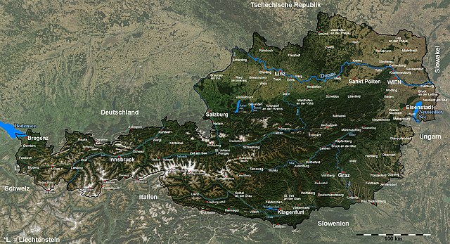
| Beskrivelse | Satellite image of Austria with provincial capitals and other annotations |
| Dato | |
| Kilde |
The image is based on a satellite image from [1]. Original image: Credit Jeff Schmaltz, MODIS Rapid Response Team, NASA/GSFC. |
| Forfatter | Michael Schmid |
| Tilladelse (Genbrug af denne fil) |
Based on a NASA image, thus in the public domain. |
| Andre versioner | Image:Austria_satellite_unannotated.jpg with no annotations except dots at the positions of a few cities, Image:Austria_satellite_annotated.jpg with some limited annotations. |
![[1]](http://visibleearth.nasa.gov/images/5947/Italy.A2003262.1005.250m.jpg)
I have marked and labelled quite a lot of places with the help of the NASA Worldwind software and several maps. It was quite some work, but also a nice exercise in geography for me ;-).
Unless I have forgotten something, the map shows (among other cities) the capitals of all districts and provinces of Austria.
Please note: The cities of Wien (Vienna) and Linz were marked a few kilometers from their actual locations in the original satellite image; this has been corrected here.[2].
Das Bild wurde in y-Richtung um ca. 5% gestreckt, um eine wenig verzerrte Karte zu erhalten. Um Österreich hervorzuheben, habe ich den Kontrast außerhalb der Grenzen Österreichs reduziert und die Grenzlinie dicker eingezeichnet, und danach durch Vergleich mit der NASA Worldwind Software und diversen Karten die Positionen diverser Orte, Berge und Pässe bestimmt und eingezeichnet.
Die Karte enthält (wenn ich keine vergessen habe) unter anderem alle Landes- und Bezirkshauptstädte Österreichs.Licensering
| Denne fil er i offentligt domæne i USA fordi den udelukkende er skabt af NASA. NASAs ophavsretspolitik erklærer at materiale udgivet af NASA ikke er omfattet af ophavsret medmindre andet er nævnt. (Se også Template:PD-USGov, NASAs ophavsretspolitik eller JPLs politik for brug af billeder.) | ||
 |
Advarsler:
|
Filhistorik
Klik på en dato/tid for at se filen som den så ud på det tidspunkt.
| Dato/tid | Miniaturebillede | Dimensioner | Bruger | Kommentar | |
|---|---|---|---|---|---|
| nuværende | 11. sep. 2005, 21:41 | | 2.550 × 1.381 (1,22 MB) | Schmid | {{Information| |Description = Satellite image of Austria with provincial capitals and other annotations | Source = The image is based on a satellite image from [http://visibleearth.nasa.gov/images/5947/Italy.A2003262.1005.250m.jpg]. Original image: Cre |
Filanvendelse
Den følgende side bruger denne fil:
Global filanvendelse
Følgende andre wikier anvender denne fil:
- Anvendelser på af.wikipedia.org
- Anvendelser på cs.wikipedia.org
- Anvendelser på de.wikipedia.org
- Anvendelser på en.wikipedia.org
- Anvendelser på fr.wikipedia.org
- Anvendelser på hu.wikipedia.org
- Anvendelser på hy.wikipedia.org
- Anvendelser på hyw.wikipedia.org
- Anvendelser på ku.wikipedia.org
- Anvendelser på nn.wikipedia.org
- Anvendelser på no.wikipedia.org
- Anvendelser på rm.wikipedia.org
- Anvendelser på ru.wikipedia.org
- Anvendelser på sk.wikipedia.org
- Anvendelser på tl.wikipedia.org
- Anvendelser på tr.wikipedia.org
- Anvendelser på uk.wikipedia.org