
Fil:CanalZone.png

Størrelse af denne forhåndsvisning: 440 × 599 pixels. Andre opløsninger: 176 × 240 pixels | 520 × 708 pixels.
Fuld opløsning (520 × 708 billedpunkter, filstørrelse: 265 KB, MIME-type: image/png)
|
|
Denne fil er fra Wikimedia Commons. Beskrivelsen af filen fra Commons er gengivet nedenfor. |
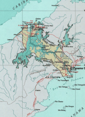
Map of the Panama Canal Zone. from the National Atlas archive copy at the Wayback Machine via American Memory.
This map was obtained from an edition of the National Atlas of the United States. Like almost all works of the U.S. federal government, works from the National Atlas are in the public domain in the United States.
Online access: NationalAtlas.gov | 1970 print edition: Library of Congress, Perry-Castañeda Library
|
Oprindelig oplægningslog
| Dato/tid | Dimensioner | Bruger | Kommentar |
|---|---|---|---|
| 29. april 2005, 04:29:04 | 520 × 708 (314279 bytes) | Hoshie (diskussion · bidrag) | Map of the Panama Canal Zone. from the [http://www.nationalatlas.gov/ National Atlas] via [http://memory.loc.gov/ammem/gmdhtml/census3.html American Memory]. {{PD-USGov-Atlas}} |
Filhistorik
Klik på en dato/tid for at se filen som den så ud på det tidspunkt.
| Dato/tid | Miniaturebillede | Dimensioner | Bruger | Kommentar | |
|---|---|---|---|---|---|
| nuværende | 1. okt. 2014, 11:24 | | 520 × 708 (265 KB) | RokerHRO | optipng -o7 → 23.74% decrease |
| 29. aug. 2014, 12:52 |  | 520 × 708 (348 KB) | GifTagger | Bot: Converting file to superior PNG file. (Source: CanalZone.gif). This GIF was problematic due to non-greyscale color table. |
Filanvendelse
De følgende 2 sider bruger denne fil:
Global filanvendelse
Følgende andre wikier anvender denne fil:
- Anvendelser på ang.wikipedia.org
- Anvendelser på ar.wikipedia.org
- Anvendelser på be.wikipedia.org
- Anvendelser på bg.wikipedia.org
- Anvendelser på bn.wikipedia.org
- Anvendelser på ca.wikipedia.org
- Anvendelser på cs.wikipedia.org
- Anvendelser på de.wikipedia.org
- Anvendelser på en.wikipedia.org
- Anvendelser på eo.wikipedia.org
- Anvendelser på es.wikipedia.org
- Anvendelser på fa.wikipedia.org
- Anvendelser på fr.wikipedia.org
- Anvendelser på he.wikipedia.org
- Anvendelser på hu.wikipedia.org
- Anvendelser på id.wikipedia.org
- Anvendelser på it.wikipedia.org
- Anvendelser på ja.wikipedia.org
- Anvendelser på ka.wikipedia.org
- Anvendelser på ko.wikipedia.org
- Anvendelser på lt.wikipedia.org
- Anvendelser på lv.wikipedia.org
Vis flere globale anvendelser af denne fil.