
Fil:EasternSolomonsChart.jpg
Størrelse af denne forhåndsvisning: 559 × 599 pixels. Andre opløsninger: 224 × 240 pixels | 448 × 480 pixels | 640 × 686 pixels.
Fuld opløsning (640 × 686 billedpunkter, filstørrelse: 90 KB, MIME-type: image/jpeg)
|
|
Denne fil er fra Wikimedia Commons. Beskrivelsen af filen fra Commons er gengivet nedenfor. |
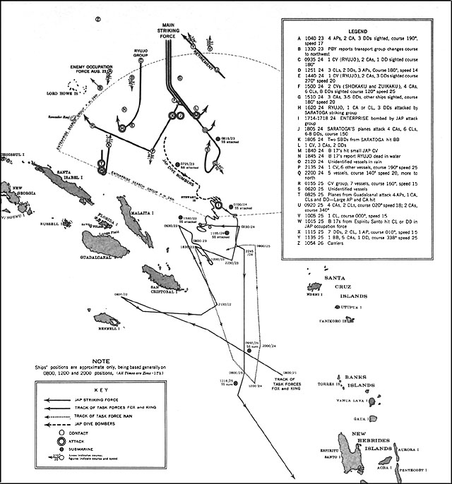
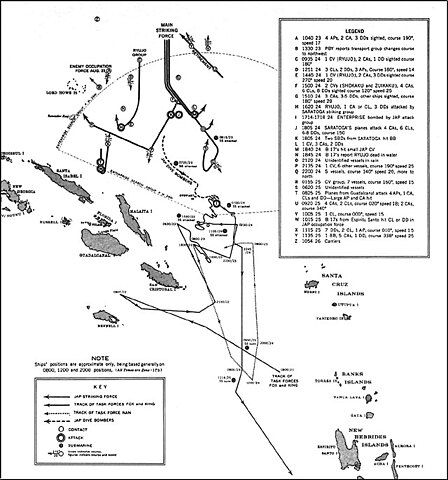
| Beskrivelse | US Navy map of The Battle of the Eastern Solomons. Tracks of Allied (U.S.) forces are most likely fairly accurate. Tracks of Japanese forces are approximate and/or conjectured. The term "Jap" is used as shorthand for "Japanese" on the map. It's unknown whether this was used pejoratively in this publication or as an accepted abbreviation at that time. |
| Dato | |
| Kilde | US Government ( http://www.ibiblio.org/hyperwar/USN/USN-CN-ESols/index.html )The Battle of the Eastern Solomons, 23-25 August 1942, Navy Department Office of Naval Intelligence, Combat Narrative |
| Forfatter | US Government |
| Tilladelse (Genbrug af denne fil) |
US Government/public domain |
This file is a work of a sailor or employee of the U.S. Navy, taken or made as part of that person's official duties. As a work of the U.S. federal government, it is in the public domain in the United States.
|
 | |
| Denne fil er blevet identificeret som værende fri for kendte restriktioner under lov om ophavsret, herunder alle relaterede og tilstødende rettigheder. | ||
Filhistorik
Klik på en dato/tid for at se filen som den så ud på det tidspunkt.
| Dato/tid | Miniaturebillede | Dimensioner | Bruger | Kommentar | |
|---|---|---|---|---|---|
| nuværende | 24. maj 2006, 18:12 | | 640 × 686 (90 KB) | Cla68 | {{Information| |Description= US Navy map of The Battle of the Eastern Solomons. This map may not be entirely accurate since it was published before World War II was over. |Source= US Government (http://www.ibiblio.org/hyperwar/USN/USN-CN-ESols/index.html |
Filanvendelse
Den følgende side bruger denne fil:
Global filanvendelse
Følgende andre wikier anvender denne fil:
- Anvendelser på azb.wikipedia.org
- Anvendelser på cs.wikipedia.org
- Anvendelser på en.wikipedia.org
- Anvendelser på es.wikipedia.org
- Anvendelser på fr.wikipedia.org
- Anvendelser på he.wikipedia.org
- Anvendelser på hu.wikipedia.org
- Anvendelser på id.wikipedia.org
- Anvendelser på ko.wikipedia.org
- Anvendelser på nl.wikipedia.org
- Anvendelser på sr.wikipedia.org
- Anvendelser på vi.wikipedia.org
- Anvendelser på zh.wikipedia.org