
Fil:Europe 814.png

Størrelse af denne forhåndsvisning: 777 × 600 pixels. Andre opløsninger: 311 × 240 pixels | 622 × 480 pixels | 995 × 768 pixels | 1.280 × 988 pixels | 1.393 × 1.075 pixels.
Fuld opløsning (1.393 × 1.075 billedpunkter, filstørrelse: 169 KB, MIME-type: image/png)
|
|
Denne fil er fra Wikimedia Commons. Beskrivelsen af filen fra Commons er gengivet nedenfor. |

Beskrivelse
| Beskrivelse |
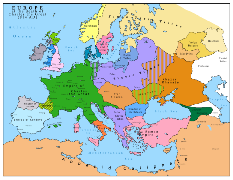
English: Map of Europe after the death of Charles the Great (814 AD). Original map made by Charles Colbeck, The Public Schools Historical Atlas (1905). |
|||
| Dato | 2009-04-15. Source date: 1905 by Longmans, Green; New York, London, Bombay 1905. | |||
| Kilde | Own work based on: Europe 814.jpg | |||
| Forfatter | Bukkia (diskussion · bidrag) | |||
| Andre versioner |
|


Licensering
| Jeg, indehaveren af ophavsretten til dette værk, udgiver dette værk som offentlig ejendom. Dette gælder i hele verden. I nogle lande er dette ikke juridisk muligt. I så fald: Jeg giver enhver ret til at anvende dette værk til ethvert formål, uden nogen restriktioner, medmindre sådanne restriktioner er påkrævede ved lov. |
_en.png)
.png)
.jpg)
Filhistorik
Klik på en dato/tid for at se filen som den så ud på det tidspunkt.
| Dato/tid | Miniaturebillede | Dimensioner | Bruger | Kommentar | |
|---|---|---|---|---|---|
| nuværende | 26. apr. 2023, 13:09 | | 1.393 × 1.075 (169 KB) | OrionNimrod | Reverted to version as of 13:52, 23 December 2015 (UTC) restore |
| 2. maj 2019, 18:09 |  | 1.370 × 1.047 (124 KB) | Julieta39 | Slavs also in the Avars and Bulgars kingdoms | |
| 23. dec. 2015, 15:52 |  | 1.393 × 1.075 (169 KB) | Ercwlff | at that time armenia was already part of Arab caliphate.. and there were several Georgian kingdoms or principalities in the north of them | |
| 8. jun. 2015, 15:52 |  | 1.393 × 1.075 (157 KB) | Zorion | Vasconia in rebellion | |
| 28. maj 2015, 19:49 |  | 1.393 × 1.075 (156 KB) | Zorion | From 812 to 824, Vasconia was ruled by Vascons (sourced can be found anywhere in spanish, basque or french). This map was wrong for that specific year. Seems that historian wanted to credit a famous king but, he was dead when Wasconia got back under th... | |
| 24. aug. 2014, 17:58 |  | 1.393 × 1.075 (230 KB) | Martin H. | Reverted to version as of 14:53, 31 January 2010: File is consistent with its source file File:Europe 814.jpg; change conflicts with en:Duchy_of_Vasconia#Carolingian duchy (769–864) | |
| 24. aug. 2014, 16:42 |  | 1.393 × 1.075 (156 KB) | Zorion | Vasconia was independant from frankish kingdom until 824 | |
| 31. jan. 2010, 16:53 |  | 1.393 × 1.075 (230 KB) | Bukkia | == {{int:filedesc}} == {{Information |Description={{it|1=Mappa dell'Europa alla morte di Carlo Magno (814 d.C.)}} {{en|1=Map of Europe after the death of Charles the Great (814 AD, in Italian)}} |Source=Based on File:Europe 814.jpg |Author=[[user:Buk |
Filanvendelse
Den følgende side bruger denne fil:
Global filanvendelse
Følgende andre wikier anvender denne fil:
- Anvendelser på arz.wikipedia.org
- Anvendelser på bo.wikipedia.org
- Anvendelser på de.wikipedia.org
- Anvendelser på el.wikipedia.org
- Anvendelser på en.wikipedia.org
- Anvendelser på es.wikipedia.org
- Anvendelser på fa.wikipedia.org
- Anvendelser på fr.wikipedia.org
- Anvendelser på gl.wikipedia.org
- Anvendelser på he.wikipedia.org
- Anvendelser på hu.wikipedia.org
- Anvendelser på hy.wikipedia.org
- Anvendelser på id.wikipedia.org
- Anvendelser på it.wikipedia.org
- Anvendelser på ko.wikipedia.org
- Anvendelser på lmo.wikipedia.org
- Anvendelser på lv.wikipedia.org
- Anvendelser på mk.wikipedia.org
- Anvendelser på pl.wikipedia.org
- Anvendelser på ro.wikipedia.org
- Anvendelser på sh.wikipedia.org
- Anvendelser på sr.wikipedia.org
- Anvendelser på sw.wikipedia.org
- Anvendelser på uk.wikipedia.org