
Fil:European Late Neolithic.gif
Fuld opløsning (1.320 × 663 billedpunkter, filstørrelse: 103 KB, MIME-type: image/gif)
|
|
Denne fil er fra Wikimedia Commons. Beskrivelsen af filen fra Commons er gengivet nedenfor. |

|
En vektorversion af dette billede (SVG) er tilgængelig. Det bør bruges i stedet for punktgrafikbilledet når det er fordelagtigt.
File:European Late Neolithic.gif → File:European-late-neolithic-english.svg
For mere information om vektorgrafik: Læs om overgangen til SVG på Commons. Se også information om MediaWikis understøttelse af SVG-billeder. |
 |
.
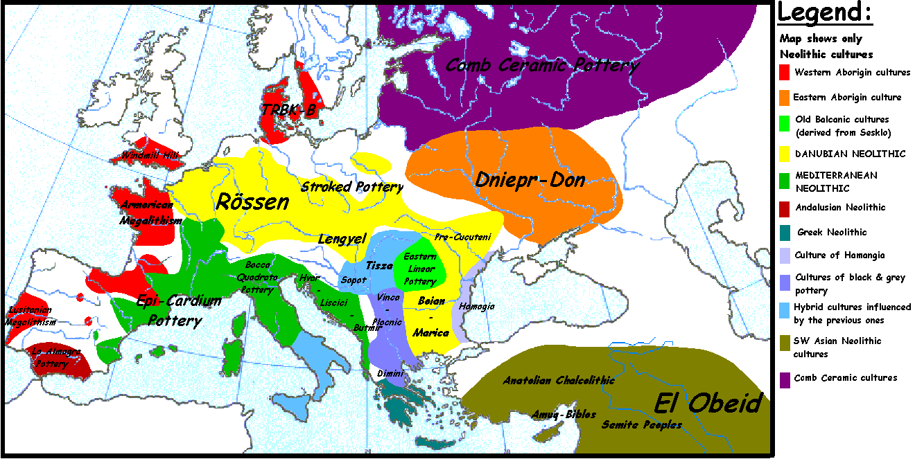
Originally uploaded to en-wiki: Quote: "20:54, 5 April 2005 . . Sugaar . . 1320x663 (103135 bytes) (Map of the European Late Neolithic (c. 3500 BCE), showing the main cultures. Made by Sugaar. Free use authorized by the author.)", changed by: "10:05, 28 August 2005 . . Clarifer . . 1320x663 (106193 bytes) (Added the area of the Comb Ceramic cultures. Source: National Board of Antiquities, Finland. www.nba.fi)".
Was uploaded with "PD-self".
_en.png)
.png)
.jpg)
| Jeg, indehaveren af ophavsretten til dette værk, udgiver dette værk som offentlig ejendom. Dette gælder i hele verden. I nogle lande er dette ikke juridisk muligt. I så fald: Jeg giver enhver ret til at anvende dette værk til ethvert formål, uden nogen restriktioner, medmindre sådanne restriktioner er påkrævede ved lov. |
Filhistorik
Klik på en dato/tid for at se filen som den så ud på det tidspunkt.
| Dato/tid | Miniaturebillede | Dimensioner | Bruger | Kommentar | |
|---|---|---|---|---|---|
| nuværende | 20. apr. 2014, 19:43 | | 1.320 × 663 (103 KB) | Spiridon Ion Cepleanu | Neolithic shorelines and banks, little details |
| 6. feb. 2006, 21:55 |  | 1.320 × 663 (104 KB) | Pieter1 | This image was copied from wikipedia:en. The original description was: Map of the European Late Neolithic (c. 3500 BCE), showing the main cultures. {{PD-self}} --Sugaar 22:11, 30 October 2005 (UTC) (I'm not responsible of the modificat | |
| 31. dec. 2005, 17:00 |  | 1.320 × 663 (104 KB) | Glenn | Originally uploaded to en-wiki: Quote: "20:54, 5 April 2005 . . Sugaar . . 1320x663 (103135 bytes) (Map of the European Late Neolithic (c. 3500 BCE), showing the main cultures. Made by Sugaar. Free use authorized by the author.)", changed by: "10:05, 28 A |
Filanvendelse
De følgende 3 sider bruger denne fil:
Global filanvendelse
Følgende andre wikier anvender denne fil:
- Anvendelser på ast.wikipedia.org
- Anvendelser på az.wikipedia.org
- Anvendelser på ba.wikipedia.org
- Anvendelser på be.wikipedia.org
- Anvendelser på bs.wikipedia.org
- Anvendelser på ca.wikipedia.org
- Anvendelser på cv.wikipedia.org
- Anvendelser på de.wikipedia.org
- Anvendelser på en.wikipedia.org
- Anvendelser på et.wikipedia.org
- Anvendelser på fi.wikipedia.org
- Anvendelser på fr.wikipedia.org
- Anvendelser på fy.wikipedia.org
- Anvendelser på ga.wikipedia.org
- Anvendelser på hu.wikipedia.org
- Anvendelser på it.wikipedia.org
- Anvendelser på ja.wikipedia.org
- Anvendelser på lld.wikipedia.org
- Anvendelser på lt.wikipedia.org
- Anvendelser på pl.wikipedia.org
- Anvendelser på ro.wikipedia.org
- Anvendelser på ru.wikipedia.org
- История Европы
- Каменный век в Европе
- Доисторическая Франция
- Культура воронковидных кубков
- Бутмирская культура
- Культура накольчатой керамики
- Рёссен
- Дунайские культуры
- Доисторическая Белоруссия
- Участник:AlexPin/Археологические культуры Европы
- Доисторический Карпато-Балканский регион
- Участник:Infoman 2016-17 Group 1/sandbox/Draft
- Anvendelser på sk.wikipedia.org
- Anvendelser på sl.wikipedia.org
Vis flere globale anvendelser af denne fil.