
Fil:Fort Laramie Treaty, 1851. Indian territories, Like A Fishhook Village, Oregon Trail and Santa Fe Trail.png

Størrelse af denne forhåndsvisning: 534 × 599 pixels. Andre opløsninger: 214 × 240 pixels | 428 × 480 pixels | 684 × 768 pixels | 1.243 × 1.395 pixels.
Fuld opløsning (1.243 × 1.395 billedpunkter, filstørrelse: 4,3 MB, MIME-type: image/png)
|
|
Denne fil er fra Wikimedia Commons. Beskrivelsen af filen fra Commons er gengivet nedenfor. |
Beskrivelse
| Beskrivelse |
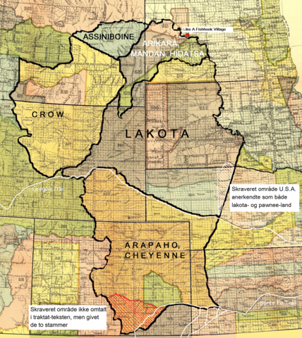
Dansk: Fort Laramie traktatens (1851) territorier for lakota-, cheyenne- og arapaho-, crow-, assiniboine- samt mandan-, hidatsa- og arikara-stammen. Endvidere Like A Fishhook Village, Oregon Trail, Santa Fe Trail samt området syd for Arkansas River tildelt cheyennerne- og arapahoerne p.g.a. en misforstået traktattekst (rød skravering). Også området anerkendt som både lakota- og pawnee-land af U.S.A. (hvid skravering).
English: The territories of the Lakota, Cheyenne and Arapaho, Crow, Assiniboine and Mandan, Hidatsa and Arikara tribes. Also Like A Fishhook Village, Oregon Trail and Santa Fe Trail. Further, the south area added to the territory of the Cheyenne and Arapaho due to a misunderstanding of the treaty text (red hatching) – (see ”Historical data and remarks”. U.S Serial Set, Number 4015, 56. Congress, 1. Session. P. 786.) Also the area recognized by the U.S. as territory of both the Lakota and the Pawnee (white hatching) - (See Blaine, Martha Royce: ”Pawnee Passage, 1870-1875.” Norman and London. 1990. P. 212. Also Royce, Charles C.: ”Indian Land Cessions in the United States.” Bureau of American Ethnology. Eighteenth Annual Report. Part 2. Washington, 1899. P. 819.) |
| Dato | |
| Kilde | Royce, Charles C.: Indian Land Cessions in the United States. Bureau of American Ethnology. Eighteenth Annual Report. Part 2. Washington, 1899. GPO |
| Forfatter | Compiled by Charles C, Royce (original maps now adapted to written text) |
Licensering
| This work is from the Library of Congress. According to the library, there are no known copyright restrictions on the use of this work. |  |

|
This is a file uploaded through the Danish Wikipedia, which has not been reviewed on Commons:
|
Filhistorik
Klik på en dato/tid for at se filen som den så ud på det tidspunkt.
| Dato/tid | Miniaturebillede | Dimensioner | Bruger | Kommentar | |
|---|---|---|---|---|---|
| nuværende | 9. jan. 2022, 11:02 | | 1.243 × 1.395 (4,3 MB) | Indianertosset | Uploaded a work by Compiled by Charles C, Royce (original maps now adapted to written text) from Royce, Charles C.: Indian Land Cessions in the United States. Bureau of American Ethnology. Eighteenth Annual Report. Part 2. Washington, 1899. GPO with UploadWizard |
Filanvendelse
Den følgende side bruger denne fil:
Global filanvendelse
Følgende andre wikier anvender denne fil:
- Anvendelser på it.wikipedia.org