
Fil:Hidatsa village Sakakawea (32ME11) at Knife River. 1911 map by George F. Will.png

Størrelse af denne forhåndsvisning: 559 × 599 pixels. Andre opløsninger: 224 × 240 pixels | 448 × 480 pixels | 717 × 768 pixels | 1.227 × 1.315 pixels.
Fuld opløsning (1.227 × 1.315 billedpunkter, filstørrelse: 1,24 MB, MIME-type: image/png)
|
|
Denne fil er fra Wikimedia Commons. Beskrivelsen af filen fra Commons er gengivet nedenfor. |
_at_Knife_River._1911_map_by_George_F._Will.png?uselang=da)
Beskrivelse
| Beskrivelse |
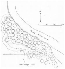
Dansk: Kortet viser hidatsaernes by Sakakawea (32ME11) ved Knife River i Mercer County, North Dakota, der var beboet fra ca. 1795 til foråret 1834. George F. Will opmålte byen i 1911. Hver cirkel repræsenterer en jordhytte. Dele af byen er styrtet i Knife River. Området er en del af Knife River Indian Villages National Historic Site.
English: The map shows the village of the Awatixa Hidatsa Sakakawea (32ME11) at Knife River, Mercer County, North Dakota. The people lived there from around 1795 to the spring 1834. George F. Will made the map in 1911. Every circle indicates an earthlodge. Part of the village is taken by the river. The area is located in Knife River Indian Villages National Historic Site. |
| Dato | |
| Kilde | Will, G. F.: ”Archaeology of the Missouri Valley." Anthropological Papers of the American Museum of Natural History. 22 (6), 1924. New York. Page 324, fig. 9 |
| Forfatter | George F. Will |
Licensering
Dette værk er offentlig ejendom i Amerikas Forenede Stater (USA) fordi det blev udgivet (eller registreret hos U.S. Copyright Office) før 1 januar 1929.
For at et værk skal kunne lægges på Commons som offentlig ejendom skal ophavsretten være udløbet i både USA og oprindelseslandet. Hvis værket ikke er amerikansk, skal det have yderligere en ophavsretslicens, der angiver ophavsretsstatus i oprindelseslandet.
|

|
This is a file uploaded through the Danish Wikipedia, which has not been reviewed on Commons:
|
Filhistorik
Klik på en dato/tid for at se filen som den så ud på det tidspunkt.
| Dato/tid | Miniaturebillede | Dimensioner | Bruger | Kommentar | |
|---|---|---|---|---|---|
| nuværende | 20. jul. 2022, 10:33 | | 1.227 × 1.315 (1,24 MB) | Indianertosset | Uploaded a work by George F. Will from Will, G. F.: ”Archaeology of the Missouri Valley." Anthropological Papers of the American Museum of Natural History. 22 (6), 1924. New York. Page 324, fig. 9 with UploadWizard |
Filanvendelse
Den følgende side bruger denne fil:
_at_Knife_River._1911_map_by_George_F._Will.png)