
Fil:Is-wb-gs-gh.png

Fuld opløsning (1.428 × 2.289 billedpunkter, filstørrelse: 259 KB, MIME-type: image/png)
|
|
Denne fil er fra Wikimedia Commons. Beskrivelsen af filen fra Commons er gengivet nedenfor. |
Beskrivelse
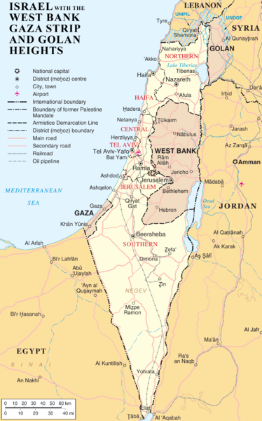
| Beskrivelse | en:Category:Maps of the Palestinian territories |
| Dato |
1. april 2007 (original upload date) |
| Kilde |
Transferred from en.wikipedia to Commons. |
| Forfatter | (Original text: ChrisO) |
Licensering
| Dette værk er blevet udgivet som offentlig ejendom af dets skaber, ChrisO at engelsk Wikipedia. Dette gælder i hele verden. I nogle lande er dette ikke juridisk muligt. I så fald: ChrisO giver enhver ret til at anvende dette værk til ethvert formål, uden nogen restriktioner, medmindre sådanne restriktioner er påkrævede ved lov. |
| This image is a map derived from a United Nations map.
Unless stated otherwise, UN maps are to be considered in the public domain. This applies worldwide. UN maps are, in principle, open source material and you can use them in your work or for making your own map. UN requests however that you delete the UN name, logo and reference number upon any modification to the map. Content of your map will be your responsibility. You can state in your publication, if you wish, something like: based on UN map … (map name, map number, revision number and date). See: Geospatial Information Section. And: Geospatial, location data for a better world. |
 |
Oprindelig oplægningslog
- 2007-04-01 21:20 ChrisO 1428×2289×8 (264954 bytes)
- 2007-04-01 19:55 ChrisO 1428×2289×8 (265283 bytes) == Summary == {{Information |Description= {{en|Map of [[Israel]], the [http://en.wikipedia.org/wiki/Palestinian_territories Palestinian territories] ([[West Bank]] and [[Gaza Strip]]), the [[Golan Heights]], and portions of neighbouring countries. Also [[
Filhistorik
Klik på en dato/tid for at se filen som den så ud på det tidspunkt.
| Dato/tid | Miniaturebillede | Dimensioner | Bruger | Kommentar | |
|---|---|---|---|---|---|
| nuværende | 2. jul. 2007, 17:09 | | 1.428 × 2.289 (259 KB) | Liftarn | {{Information |Description=en:Category:Maps of Israel en:Category:Maps of the Palestinian territories |Source=Originally from [http://en.wikipedia.org en.wikipedia]; description page is/was [http://en.wikipedia.org/w/index.php?title=Image%3AIs-w |
Filanvendelse
Den følgende side bruger denne fil: