
Fil:Larson -, Spiry-Eklo - and Travis 2 Site in Wolworth County, South Dakota.png
Størrelse af denne forhåndsvisning: 555 × 599 pixels. Andre opløsninger: 222 × 240 pixels | 445 × 480 pixels | 712 × 768 pixels | 949 × 1.024 pixels | 2.031 × 2.192 pixels.
Fuld opløsning (2.031 × 2.192 billedpunkter, filstørrelse: 2,56 MB, MIME-type: image/png)
|
|
Denne fil er fra Wikimedia Commons. Beskrivelsen af filen fra Commons er gengivet nedenfor. |
Beskrivelse
| Beskrivelse |
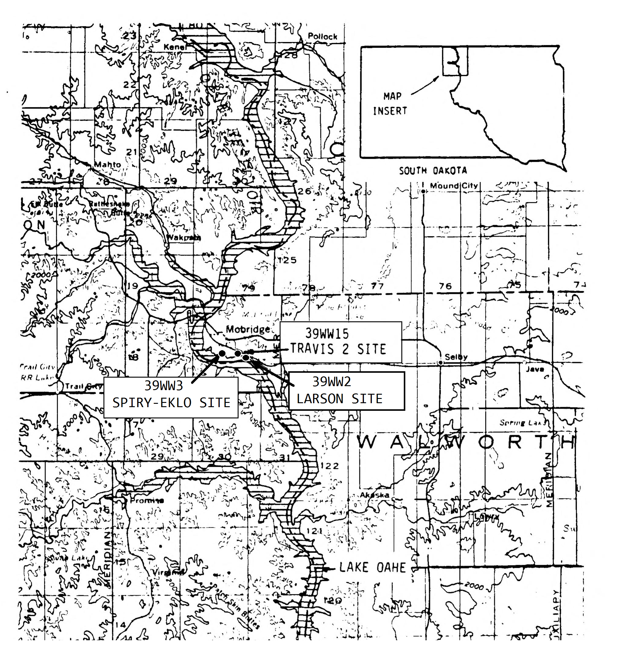
Dansk: Kortet viser placeringen af en by befolket af arikaraer fra ca. 1675 til senest 1750, Larson Site i South Dakota. Mindst 71 indbyggere blev dræbt under en massakre begået af andre indianere før 1750, hvorunder flere jordhytter blev stukket i brand. Kortet viser desuden er de arkæologiske steder Travis 2 og Spiry-Eklo tæt ved Larson.
English: The map shows the location of an Arikara village, Larson Site (39WW2), in Walworth County, South Dakota, used from cirka 1675 to latest 1750. Seventy-one victims of a massacre on the villagers inflicted by other natives were found during excavations i 1964. Some of the lodges were burned. The map also shows the nearby sites of Travis 2 and Spiry-Eklo. |
| Dato | |
| Kilde | ”DTIC ADA245648: Results of the 1987 Archeological Investigations at the Travis 2 Site, 39WW15, Walworth County, South Dakota.” Page 2 (Detail of the map used and further adapted to text about Larson Site, (39WW2)) |
| Forfatter | Creater: Defence Technical Information Center, 1988-09-01 |
Licensering
Dette værk er offentlig ejendom fordi det er skabt af Amerikas Forenede Staters føderale regering, eller en person eller institution arbejdende for denne. Ifølge Titel 17, Kapitel 1, Sektion 105 af US Code er sådanne værker ikke omfattede af ophavsret.
Note: Dette gælder kun for værker af den Føderale Regering og ikke for værker af de enkelte delstater, territorier, commonwealth, amt, kommune, eller anden subnational enhed.
|
 | |
| Denne fil er blevet identificeret som værende fri for kendte restriktioner under lov om ophavsret, herunder alle relaterede og tilstødende rettigheder. | ||

|
This is a file uploaded through the Danish Wikipedia, which has not been reviewed on Commons:
|
Filhistorik
Klik på en dato/tid for at se filen som den så ud på det tidspunkt.
| Dato/tid | Miniaturebillede | Dimensioner | Bruger | Kommentar | |
|---|---|---|---|---|---|
| nuværende | 16. jul. 2022, 19:55 | | 2.031 × 2.192 (2,56 MB) | Indianertosset | Uploaded a work by Creater: Defence Technical Information Center, 1988-09-01 from ”DTIC ADA245648: Results of the 1987 Archeological Investigations at the Travis 2 Site, 39WW15, Walworth County, South Dakota.” Page 2 (Detail of the map used and further adapted to text about Larson Site, (39WW2)) with UploadWizard |
Filanvendelse
Den følgende side bruger denne fil: