
Fil:Lesser Prairie Chicken Tympanuchus pallidicinctus distribution map.png
Fuld opløsning (800 × 763 billedpunkter, filstørrelse: 124 KB, MIME-type: image/png)
|
|
Denne fil er fra Wikimedia Commons. Beskrivelsen af filen fra Commons er gengivet nedenfor. |
Beskrivelse
| Beskrivelse |
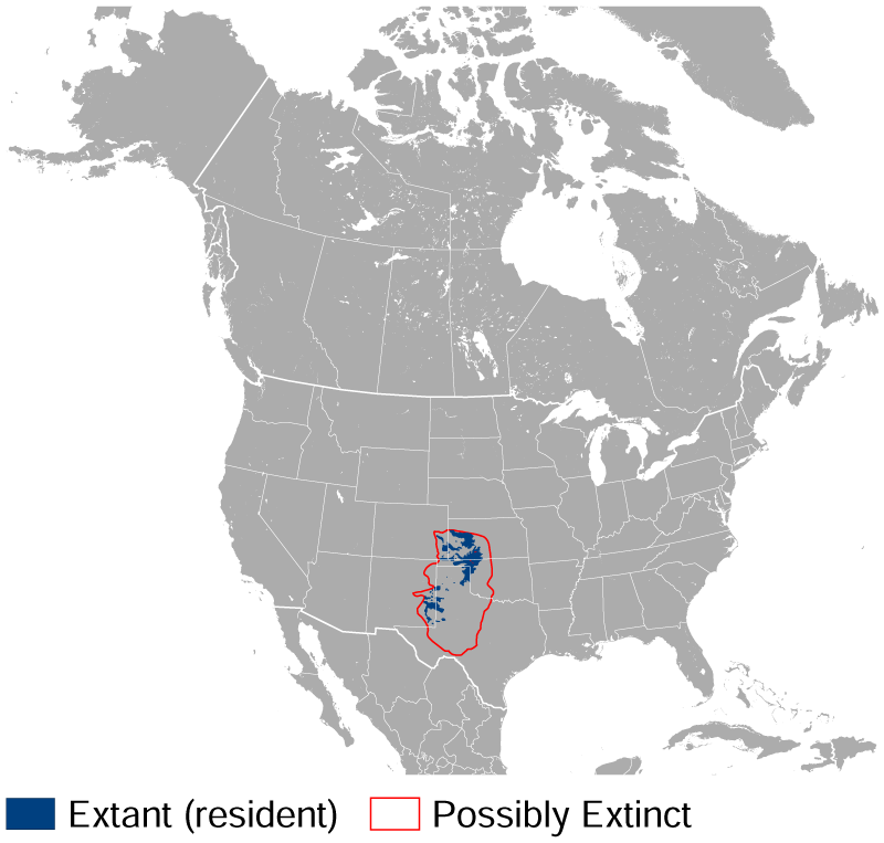
English: Geographical distribution of the Lesser Prairie Chicken Tympanuchus pallidicinctus. The map was created using the Generic Mapping Tools, GMT, version 5.1.2. |
| Dato | |
| Kilde |
Own work using: the IUCN Red List spatial data to draw the borders of the Tympanuchus pallidicinctus range: |
| Forfatter | Darekk2 using the IUCN Red List spatial data |
Licensering
Attribution: The author of the work and the IUCN Red List spatial data.
You must provide the appropriate credit for the IUCN Red List spatial data:
BirdLife International and NatureServe (2014) Bird Species Distribution Maps of the World. 2012. Tympanuchus pallidicinctus. In: IUCN 2015. The IUCN Red List of Threatened Species. Version 2015.2. http://www.iucnredlist.org. Downloaded on 09 July 2015.
and the IUCN Red List spatial data
- Du må frit:
- at dele – at kopiere, distribuere og overføre værket
- at remixe – at tilpasse værket
- Under følgende vilkår:
- kreditering – Du skal give passende kreditering, angive et link til licensen, og oplyse om der er foretaget ændringer. Du må gøre det på enhver fornuftig måde, men ikke på en måde der antyder at licensgiveren godkender dig eller din anvendelse.
- deling på samme vilkår – Hvis du bearbejder, ændrer eller bygger videre på dette værk, skal du distribuere dine bidrag under den samme eller en kompatibel licens som originalen.
Filhistorik
Klik på en dato/tid for at se filen som den så ud på det tidspunkt.
| Dato/tid | Miniaturebillede | Dimensioner | Bruger | Kommentar | |
|---|---|---|---|---|---|
| nuværende | 9. jul. 2015, 17:00 | | 800 × 763 (124 KB) | Darekk2 | User created page with UploadWizard |
Filanvendelse
Den følgende side bruger denne fil:
Global filanvendelse
Følgende andre wikier anvender denne fil:
- Anvendelser på it.wikipedia.org
- Anvendelser på nv.wikipedia.org
- Anvendelser på uk.wikipedia.org