
Fil:Map of Distant Early Warning (DEW) Line.jpg

Størrelse af denne forhåndsvisning: 800 × 531 pixels. Andre opløsninger: 320 × 213 pixels | 640 × 425 pixels | 1.024 × 680 pixels | 1.280 × 850 pixels | 3.000 × 1.993 pixels.
Fuld opløsning (3.000 × 1.993 billedpunkter, filstørrelse: 3,38 MB, MIME-type: image/jpeg)
|
|
Denne fil er fra Wikimedia Commons. Beskrivelsen af filen fra Commons er gengivet nedenfor. |
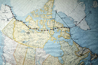
| Beskrivelse | A map of North America near the Arctic Circle showing 30 radar sites spread out along the Distant Early Warning (DEW) Line. Running from Alaska, across Northern Canada to Greenland, the line is approximately 3,600 miles long. | |||
| Dato | Taget den 20. februar 1987 | |||
| Kilde | ID:DFST8803442 | |||
| Forfatter |
Service Depicted: Air Force Command Shown: F3203 Camera Operator: TECH. SGT. DONALD L. WETTERMAN |
|||
| Tilladelse (Genbrug af denne fil) |
|

_Line.jpg?uselang=da)
Filhistorik
Klik på en dato/tid for at se filen som den så ud på det tidspunkt.
| Dato/tid | Miniaturebillede | Dimensioner | Bruger | Kommentar | |
|---|---|---|---|---|---|
| nuværende | 1. dec. 2006, 02:06 | | 3.000 × 1.993 (3,38 MB) | Dual Freq | {{Information |Source=[http://www.dodmedia.osd.mil/Assets/1988/Air_Force/DF-ST-88-03442.JPEG ID:DFST8803442] |Author=Service Depicted: Air Force</br>Command Shown: F3203</br>Camera Operator: TECH. SGT. DONALD L. WETTERMAN |Description=A map of North Amer |
Filanvendelse
Den følgende side bruger denne fil:
Global filanvendelse
Følgende andre wikier anvender denne fil:
- Anvendelser på de.wikipedia.org
- Anvendelser på en.wikipedia.org
- Anvendelser på fr.wikipedia.org
- Anvendelser på it.wikipedia.org
- Anvendelser på ja.wikipedia.org
- Anvendelser på no.wikipedia.org
- Anvendelser på pl.wikipedia.org
- Anvendelser på www.wikidata.org
_Line.jpg)