
Fil:Map of South Dakota highlighting Minnehaha County.svg

Size of this PNG preview of this SVG file: 800 × 492 pixels. Andre opløsninger: 320 × 197 pixels | 640 × 394 pixels | 1.024 × 630 pixels | 1.280 × 788 pixels | 2.560 × 1.576 pixels | 6.226 × 3.832 pixels.
Fuld opløsning (SVG fil, basisstørrelse 6.226 × 3.832 pixels, filstørrelse: 47 KB)
|
|
Denne fil er fra Wikimedia Commons. Beskrivelsen af filen fra Commons er gengivet nedenfor. |
Beskrivelse
| Beskrivelse |
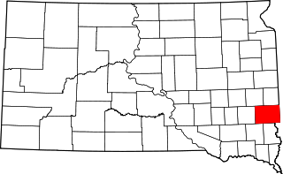
English: This is a locator map showing Minnehaha County in South Dakota. For more information, see Commons:United States county locator maps. |
| Dato | |
| Kilde |
Eget arbejde: English: The maps use data from nationalatlas.gov, specifically countyp020.tar.gz on the Raw Data Download page. The maps also use state outline data from statesp020.tar.gz. The Florida maps use hydrogm020.tar.gz to display Lake Okeechobee. |
| Forfatter | David Benbennick |
Licensering
| Jeg, indehaveren af ophavsretten til dette værk, udgiver dette værk som offentlig ejendom. Dette gælder i hele verden. I nogle lande er dette ikke juridisk muligt. I så fald: Jeg giver enhver ret til at anvende dette værk til ethvert formål, uden nogen restriktioner, medmindre sådanne restriktioner er påkrævede ved lov. |
Filhistorik
Klik på en dato/tid for at se filen som den så ud på det tidspunkt.
| Dato/tid | Miniaturebillede | Dimensioner | Bruger | Kommentar | |
|---|---|---|---|---|---|
| nuværende | 12. feb. 2006, 18:29 | | 6.226 × 3.832 (47 KB) | David Benbennick | {{subst:User:Dbenbenn/clm|county=Minnehaha County|state=South Dakota|type=county}} |
Filanvendelse
Den følgende side bruger denne fil:
Global filanvendelse
Følgende andre wikier anvender denne fil:
- Anvendelser på ar.wikipedia.org
- Anvendelser på bg.wikipedia.org
- Anvendelser på bpy.wikipedia.org
- Anvendelser på cdo.wikipedia.org
- Anvendelser på ceb.wikipedia.org
- Anvendelser på ce.wikipedia.org
- Anvendelser på cy.wikipedia.org
- Anvendelser på de.wikipedia.org
- Anvendelser på en.wikipedia.org
- List of counties in South Dakota
- Minnehaha County, South Dakota
- Baltic, South Dakota
- Brandon, South Dakota
- Colton, South Dakota
- Crooks, South Dakota
- Dell Rapids, South Dakota
- Garretson, South Dakota
- Hartford, South Dakota
- Humboldt, South Dakota
- Sherman, South Dakota
- Valley Springs, South Dakota
- Sioux Falls, South Dakota
- Rowena, South Dakota
- Lyons, South Dakota
- Renner, South Dakota
- Corson, South Dakota
- Washington Pavilion of Arts and Science
- Booge, South Dakota
- Benclare, South Dakota
- Ellis, South Dakota
Vis flere globale anvendelser af denne fil.