
Fil:NEAT GBT engl.png

Størrelse af denne forhåndsvisning: 539 × 600 pixels. Andre opløsninger: 216 × 240 pixels | 431 × 480 pixels | 852 × 948 pixels.
Fuld opløsning (852 × 948 billedpunkter, filstørrelse: 1,91 MB, MIME-type: image/png)
|
|
Denne fil er fra Wikimedia Commons. Beskrivelsen af filen fra Commons er gengivet nedenfor. |
Beskrivelse
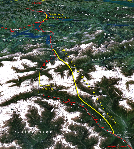
| Beskrivelse |
Situation of the northern part of the Gotthard axis as part of the New Railway Link through the Alps NRLA / Alptransit project in Switzerland with Gotthard and Zimmerberg base tunnels |
| Dato | |
| Kilde | topomap: produced with NASA WorldWind 1.3 / overlay drawing by: Cooper.ch |
| Forfatter | --Cooper.ch 19:30, 12 August 2006 (UTC) |
| Tilladelse (Genbrug af denne fil) |
NASA satellite imagery is in public domain, and so is my overlay drawing |
| Andre versioner | Original german version on de.wikipedia.org, named Bild:NEAT_Gotthardachse.png |
Licensering
| Denne fil er i offentligt domæne i USA fordi den udelukkende er skabt af NASA. NASAs ophavsretspolitik erklærer at materiale udgivet af NASA ikke er omfattet af ophavsret medmindre andet er nævnt. (Se også Template:PD-USGov, NASAs ophavsretspolitik eller JPLs politik for brug af billeder.) | ||
 |
Advarsler:
|
| Annotations | This image is annotated: View the annotations at Commons |


Filhistorik
Klik på en dato/tid for at se filen som den så ud på det tidspunkt.
| Dato/tid | Miniaturebillede | Dimensioner | Bruger | Kommentar | |
|---|---|---|---|---|---|
| nuværende | 12. aug. 2006, 21:30 | | 852 × 948 (1,91 MB) | Cooper.ch | {{Information |Description=Situation of the northern axis of the New Railway Link through the Alps NRLA in Switzerland with Gotthard and Zimmerberg base tunnels |Source=topomap: produced with NASA WorldWind 1.3 / drawing overlay by: [[User:Cooper.ch|Coope |
Filanvendelse
Den følgende side bruger denne fil:
Global filanvendelse
Følgende andre wikier anvender denne fil:
- Anvendelser på ast.wikipedia.org
- Anvendelser på bh.wikipedia.org
- Anvendelser på en.wikipedia.org
- Anvendelser på es.wikipedia.org
- Anvendelser på fa.wikipedia.org
- Anvendelser på fi.wikipedia.org
- Anvendelser på fr.wikipedia.org
- Anvendelser på he.wikipedia.org
- Anvendelser på hr.wikipedia.org
- Anvendelser på ja.wikipedia.org
- Anvendelser på jv.wikipedia.org
- Anvendelser på ml.wikipedia.org
- Anvendelser på my.wikipedia.org
- Anvendelser på nl.wikipedia.org
- Anvendelser på no.wikipedia.org
- Anvendelser på pt.wikipedia.org
- Anvendelser på rm.wikipedia.org
- Anvendelser på ro.wikipedia.org
- Anvendelser på sh.wikipedia.org
- Anvendelser på sl.wikipedia.org
- Anvendelser på sv.wikipedia.org
- Anvendelser på ta.wikinews.org
- Anvendelser på tr.wikipedia.org
- Anvendelser på zh.wikipedia.org