
Fil:Saint Vincent OnEarth WMS.png

Størrelse af denne forhåndsvisning: 600 × 600 pixels. Andre opløsninger: 240 × 240 pixels | 480 × 480 pixels | 768 × 768 pixels | 1.215 × 1.215 pixels.
Fuld opløsning (1.215 × 1.215 billedpunkter, filstørrelse: 2,22 MB, MIME-type: image/png)
|
|
Denne fil er fra Wikimedia Commons. Beskrivelsen af filen fra Commons er gengivet nedenfor. |
| Beskrivelse |
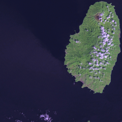
Satellite image of Saint Vincent Screenshot from NASA World Wind, OnEarth WMS global mosaic pseudocolor layer. |
| Dato | (UTC) |
| Kilde | |
| Forfatter |
|
| Dette er et retoucheret billede, hvilket betyder, at det er blevet digitalt ændret fra sin oprindelige version. Ændringer: resizing for focus. Originalen kan ses her: Saint Vincent and the Grenadines OnEarth WMS.png. Ændringer blev udført af Xfigpower.
|
| This image is in the public domain because it is a screenshot from NASA’s globe software World Wind using a public domain layer, such as Blue Marble, MODIS, Landsat, SRTM, USGS or GLOBE.
|
 |
Oprindelig oplægningslog
This image is a derivative work of the following images:
- File:Saint_Vincent_and_the_Grenadines_OnEarth_WMS.png licensed with PD-WorldWind
- 2006-04-29T20:36:20Z Hautala 1215x2869 (4062405 Bytes) {{PD-WorldWind}} Satellite image of Saint Vincent and the Grenadines. Screenshot from NASA World Wind, OnEarth WMS layer. [[Category:Satellite images of countries]]
Uploaded with derivativeFX
Filhistorik
Klik på en dato/tid for at se filen som den så ud på det tidspunkt.
| Dato/tid | Miniaturebillede | Dimensioner | Bruger | Kommentar | |
|---|---|---|---|---|---|
| nuværende | 19. jan. 2009, 18:47 | | 1.215 × 1.215 (2,22 MB) | Xfigpower | {{Information |Description=Satellite image of Saint Vincent Screenshot from NASA World Wind, OnEarth WMS global mosaic pseudocolor layer. |Source=*File:Saint_Vincent_and_the_Grenadines_OnEarth_WMS.png |Date=2009-01-19 16:46 (UTC) |Author=*derivative |
Filanvendelse
Den følgende side bruger denne fil:
Global filanvendelse
Følgende andre wikier anvender denne fil:
- Anvendelser på ar.wikipedia.org
- Anvendelser på az.wikipedia.org
- Anvendelser på be.wikipedia.org
- Anvendelser på br.wikipedia.org
- Anvendelser på ca.wikipedia.org
- Anvendelser på de.wikivoyage.org
- Anvendelser på es.wikipedia.org
- Anvendelser på fi.wikipedia.org
- Anvendelser på fi.wiktionary.org
- Anvendelser på frr.wikipedia.org
- Anvendelser på fr.wikipedia.org
- Anvendelser på gl.wikipedia.org
- Anvendelser på he.wikipedia.org
- Anvendelser på ja.wikipedia.org
- Anvendelser på lb.wikipedia.org
- Anvendelser på lt.wikipedia.org
- Anvendelser på pap.wikipedia.org
- Anvendelser på tr.wikipedia.org
- Anvendelser på ur.wikipedia.org
- Anvendelser på www.wikidata.org