
Bruger:Brol/sandkasse: Forskelle mellem versioner
Brol (diskussion | bidrag) No edit summary |
Brol (diskussion | bidrag) |
||
| Linje 86: | Linje 86: | ||
==Flora og fauna== |
==Flora og fauna== |
||
Vegetationen langs floden i den øvre del af afvandingsområdet along the river in the upper catchment includes [[riparian]] woodlands composed of paperbarks including; ''[[Melaleuca argentea]]'', ''[[Melaleuca bracteata]]'' and ''[[Melaleuca fluviatilis]]'' and sub-dominant eucalypts including [[Eucalyptus camaldulensis|River Red Gum]], [[Eucalyptus coolabah|Coolabah]], with minor [[Lysiphyllum cunninghamii|Bauhinia]]. Other species found include the [[Acacia salicina|wattle]]. Infestations of weeds such as [[Acacia nilotica|Prickly acacia]], Noogoora burr, Rubber vine and [[Zizyphus mauritiana|Chonky apple]] are also found.<ref name=RD>{{cite web|url=https://research.jcu.edu.au/tropwater/resources/98%2012%20Rchmdam.pdf|title=Richmond Dam and irrigation development proposal ecological issues|date=July 1998|accessdate=31 May 2015|author=Tait, Jim|publisher=[[James Cook University]]|archive-url=https://web.archive.org/web/20160304030023/https://research.jcu.edu.au/tropwater/resources/98%2012%20Rchmdam.pdf|archive-date=4 March 2016|url-status=live|df=dmy-all}}</ref> Underskoven domineres af et tæt dække af græsser The understorey is dominated by a closed cover of riparian grasses including native couch on the sandy loams adjacent the stream channels. |
|||
==Historie== |
==Historie== |
||
[[File:Edward Jukes Greig - Arrival of Burke & Wills at Flinders River, 1862.jpg|thumb|left|Burke & Wills ankommer til Flinders River, malet af Edward Jukes Greig i 1862]] |
[[File:Edward Jukes Greig - Arrival of Burke & Wills at Flinders River, 1862.jpg|thumb|left|Burke & Wills ankommer til Flinders River, malet af Edward Jukes Greig i 1862]] |
||
| Linje 99: | Linje 99: | ||
Der var store oversvømmelser langs floden i juli 1870. En farm mistede mere end 4.000 får og vejene var ufremkommelige. I 1917 blev der registreret endnu større oversvømmelser. Hughenden stod under vand og flere mennesker druknede. Der var også store oversvømmelser i 1955, 1960, 1974, 1991 og 2000.<ref>{{cite web|url=http://hardenup.org/media/347511/queensland_flood_history.pdf|title=Archive: Harden Up Chronological History of Flooding 1857-2010|accessdate=30 May 2015|publisher=Green Cross Australia|archive-url=https://web.archive.org/web/20150530161334/http://hardenup.org/media/347511/queensland_flood_history.pdf|archive-date=30 May 2015|url-status=live|df=dmy-all}}</ref> |
Der var store oversvømmelser langs floden i juli 1870. En farm mistede mere end 4.000 får og vejene var ufremkommelige. I 1917 blev der registreret endnu større oversvømmelser. Hughenden stod under vand og flere mennesker druknede. Der var også store oversvømmelser i 1955, 1960, 1974, 1991 og 2000.<ref>{{cite web|url=http://hardenup.org/media/347511/queensland_flood_history.pdf|title=Archive: Harden Up Chronological History of Flooding 1857-2010|accessdate=30 May 2015|publisher=Green Cross Australia|archive-url=https://web.archive.org/web/20150530161334/http://hardenup.org/media/347511/queensland_flood_history.pdf|archive-date=30 May 2015|url-status=live|df=dmy-all}}</ref> |
||
I 2003 fik farmeren Corbett Tritton licens til at kunstvande med vand fra Flinders River. Han dyrkede med succes afgrøder som [[durra]] og [[bomuld]] på sin farm, og andre kvægopdrættere blev interesserede. |
I 2003 fik farmeren Corbett Tritton licens til at kunstvande med vand fra Flinders River. Han dyrkede med succes afgrøder som [[durra]] og [[bomuld]] på sin farm, og andre kvægopdrættere blev interesserede. Bekymringer over konsekvenserne for miljøet gjorde, at der ikke blev udstedt flere licenser før i 2013.<ref name=ABCFR/> |
||
Kraftigt regnfald i Queensland tidligt i 2019 gav de værste oversvømmelser i mere end 50 år. Den store flodslette gjorde, at Flinders River kunne udvide sig til en bredde helt op til 60 kilometer. Oversvømmelserne medførte et stort tab af kvæg i området.<ref>{{Cite news|url=https://edition.cnn.com/2019/02/14/australia/australia-flinders-river-intl/|title=Australian river swells to 37 miles wide due to flooding, creates its own weather system|last=Berlinger|first=Joshua|date=14 February 2019|work=[[CNN]]|access-date=16 May 2019}}</ref> |
Kraftigt regnfald i Queensland tidligt i 2019 gav de værste oversvømmelser i mere end 50 år. Den store flodslette gjorde, at Flinders River kunne udvide sig til en bredde helt op til 60 kilometer. Oversvømmelserne medførte et stort tab af kvæg i området.<ref>{{Cite news|url=https://edition.cnn.com/2019/02/14/australia/australia-flinders-river-intl/|title=Australian river swells to 37 miles wide due to flooding, creates its own weather system|last=Berlinger|first=Joshua|date=14 February 2019|work=[[CNN]]|access-date=16 May 2019}}</ref> |
||
Versionen fra 19. okt. 2020, 14:23
| Flinders River | |
|---|---|
 Oversvømmet Flinders River ved Hughenden, januar 1917 | |
| Overblik | |
| Region | Queensland |
| Land |
|
| Geografi | |
| Udspring | Burra Range, Great Dividing Range |
- sted | Reedy Springs |
- højde | 816 m |
- koord. | 20°38′32″S 142°52′14″Ø / 20.64222°S 142.87056°Ø |
| Udmunding | Carpentariabugten |
- sted | Vest for Karumba |
- højde | 0 m.o.h. |
- koord. | 17°35′59″S 140°35′44″Ø / 17.59972°S 140.59556°Ø |
| Bifloder | |
- venstre | Cloncurry River, Corella River, Bynoe River |
- højre | Saxby River |
| Fysiske kendetegn | |
| Længde | 1.004 km |
| Middelvandføring | 122.2 m³/s |
| Afvandingsareal | 109.000 km² |
| Oversigtskort | |
 Udspring Udspring Udmunding Flinders Rivers udspring og udmunding
| |
Flinders River er med omkring 1.004 kilometer den længste flod i Queensland i Australien.[1] Den er navngivet til ære for Matthew Flinders, der kortlagde kysten, hvor Flinders River udløber, i 1802. Afvandingsområdet er tyndt befolket og kun i ringe grad udviklet. Flinders udspringer på vestlige skråninger af Great Dividing Range i det nordvestlige Queensland og løber overvejende mod nordvest over en flad slette før den løber ud i Carpentariabugten.
Geografi
Floden udspringer i Burra Range, en del af Great Dividing Range,[2] 110 kilometer nordøst for Hughenden og løber mod vest forbi Hughenden, Richmond og Julia Creek, derefter nordvest til Carpentariabugten 25 kilometer vest for Karumba. Afvandingsområdet afgrænses mod syd af Selwyn Range.
Med en længde på 1.004 kilometer er det den 8.-længste flod i Australien.[1] Afvandingsområdet, som dækker 109.000 km²,[3] bruges primært til græsning[4] og anden landbrug. I alt dækker det 1,5% ad det australske kontinent.[5]
Flinders River har 36 bifloder.[6] De vigtigste er Cloncurry River, Saxby River og Corella River.[3] En anden større biflod er Porcupine Creek, der har dannet en dramatisk kløft, som ligger i Porcupine Gorge National Park.[7] Floden løber gennem et permanent vandhul, Flagstone Waterhole.[6] Der er to dæmninger på floden - Flinders River Dam og Corella Dam.[4]
Flere mindre byer ligger i afvandingsområdet: McKinlay, Burke and Wills Junction, Hughenden, Richmond, Julia Creek og Cloncurry.[2]
Floden har en årlig gennemsnitlig vandudstrømning op 3,856 ×109 m3. Det højest målte er 18 ×106 m3.[8]
Flodsengen består af silt med ler og sand, sand og grus samt grus med sten.[8] En stor flad lerslette ligger i området, hvor Flinders River, Gregory River og Leichhardt Rivers løber ud i Carpentariabugten. Udmundingen ligger i området Gulf Plains Important Bird Area, som er udpeget af BirdLife International, som et vigtigt fugleområde (IBA).[9]
I 2015 boede der omkring 6.600 i afvandingsområdet.[10]
Flora og fauna
Vegetationen langs floden i den øvre del af afvandingsområdet along the river in the upper catchment includes riparian woodlands composed of paperbarks including; Melaleuca argentea, Melaleuca bracteata and Melaleuca fluviatilis and sub-dominant eucalypts including River Red Gum, Coolabah, with minor Bauhinia. Other species found include the wattle. Infestations of weeds such as Prickly acacia, Noogoora burr, Rubber vine and Chonky apple are also found.[11] Underskoven domineres af et tæt dække af græsser The understorey is dominated by a closed cover of riparian grasses including native couch on the sandy loams adjacent the stream channels.
Historie

Historisk har området været beboet af de aboriginske stammer Kalkadoon, Mitakoodi, Kukatj, Guthaarn, Mayi-Yapi, Mayi-Kulan, Mayi-Thakurti, Ngawun, Wanamarra, Mbara, Jirandali og Gugu-Badhun, som har været i området i tusinder af år.[2]
Flinders River blev navngivet i 1841 af kaptajn Wickham og løjtnant John Lort Stokes på HMS Beagle til ære for Matthew Flinders,der kortlagde kysten, hvor Flinders River udløber, i 1802. Stokes opmålte og kortlagde udmundingen af Flinders River og Albert River og navngav mange af stederne i området, heriblandt Disaster Inlet, Morning Inlet og Van Diemen River.[12]
Robert O'Hara Burke, William John Wills og Charles Gray nåede floddeltaet i 1861 og nåede dermed deres ekspeditions mål, at krydse kontinentet fra syd tll nord. Gray døde på vej tilbage til Cooper Creek, og både Burke og Wills døde ved Cooper Creek, da deres depot var forladt.[12]
Den første, der havde dyr gående i området omkring Flinders, var James Gibson, som startede Prairie Station i 1861. I 1864 blev blev flere farme oprettet af Gibson, herimellem Millungera Station og Taldora Station.[12]
Der var store oversvømmelser langs floden i juli 1870. En farm mistede mere end 4.000 får og vejene var ufremkommelige. I 1917 blev der registreret endnu større oversvømmelser. Hughenden stod under vand og flere mennesker druknede. Der var også store oversvømmelser i 1955, 1960, 1974, 1991 og 2000.[13]
I 2003 fik farmeren Corbett Tritton licens til at kunstvande med vand fra Flinders River. Han dyrkede med succes afgrøder som durra og bomuld på sin farm, og andre kvægopdrættere blev interesserede. Bekymringer over konsekvenserne for miljøet gjorde, at der ikke blev udstedt flere licenser før i 2013.[5]
Kraftigt regnfald i Queensland tidligt i 2019 gav de værste oversvømmelser i mere end 50 år. Den store flodslette gjorde, at Flinders River kunne udvide sig til en bredde helt op til 60 kilometer. Oversvømmelserne medførte et stort tab af kvæg i området.[14]
Referencer
- ^ a b "Longest Rivers". Geoscience Australia. Commonwealth of Australia. 18 november 2010. Arkiveret fra originalen 3 februar 2012. Hentet 3 juli 2011.
- ^ a b c "The Land - Overview". Southern Gulf Catchments. Arkiveret fra originalen 11 april 2015. Hentet 30 maj 2015.
- ^ a b "Flood Warning System For The Flinders River". Bureau of Meteorology. Arkiveret fra originalen 3 juni 2011. Hentet 3 juli 2011.
- ^ a b "Water resources - Overview - Queensland: Flinders River". Australian Natural Resources Atlas. Department of Sustainability, Environment, Water, Population and Communities. Arkiveret fra originalen 2 juni 2011. Hentet 3 juli 2011.
- ^ a b "From cattle country to crops: Flinders River moratorium lifted". Australian Broadcasting Corporation. 18 februar 2013. Arkiveret fra originalen 20 december 2015. Hentet 30 maj 2015.
- ^ a b Fodnotefejl: Ugyldigt
<ref>-tag; ingen tekst er angivet for referencer med navnetbonzle - ^ Shilton, Peter (2005). Natural Areas of Queensland. Mount Gravatt, Queensland: Goldpress. s. 256. ISBN 0-9758275-0-2.
- ^ a b Alisha Steward; et al. "Terrestrial invertebrates of dry river beds are not simply subsets of riparian assemblages" (PDF). Griffith University. Arkiveret (PDF) fra originalen 30 marts 2016. Hentet 31 maj 2015.
- ^ BirdLife International (2011) Important Bird Areas factsheet: Gulf Plains. Downloaded from "Archived copy". Arkiveret fra originalen 10 juli 2007. Hentet 2013-04-13.
{{cite web}}: CS1-vedligeholdelse: Arkivtitel brugt (link) CS1-vedligeholdelse: Dato automatisk oversat (link) on 01/07/2011 - ^ "Flinders River catchment". TRaCK. Arkiveret fra originalen 14 juli 2016. Hentet 30 maj 2015.
- ^ Tait, Jim (juli 1998). "Richmond Dam and irrigation development proposal ecological issues" (PDF). James Cook University. Arkiveret (PDF) fra originalen 4 marts 2016. Hentet 31 maj 2015.
- ^ a b c Palmer, Edward (1903). "Early Days in North Queensland". Project Gutenberg. Arkiveret fra originalen 3 april 2015. Hentet 30 maj 2015.
- ^ "Archive: Harden Up Chronological History of Flooding 1857-2010" (PDF). Green Cross Australia. Arkiveret (PDF) fra originalen 30 maj 2015. Hentet 30 maj 2015.
- ^ Berlinger, Joshua (14 februar 2019). "Australian river swells to 37 miles wide due to flooding, creates its own weather system". CNN. Hentet 16 maj 2019.
{{cite news}}: CS1-vedligeholdelse: Dato automatisk oversat (link)
Eksterne henvisninger
| | Denne artikel kan blive bedre, hvis der indsættes geografiske koordinater Denne artikel omhandler et emne, som har en geografisk lokation. Du kan hjælpe ved at indsætte koordinater i wikidata. |
xKategori:Floder i Australien xKategori:Queensland
|
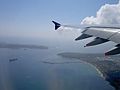
Sydney from Botany Bay looking north (aerial).jpg Aerial photo of Sydney showing Botany Bay in the foreground. The two protrusions into the bay are runways of Sydney Airport. | |
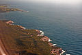
Botany Bay, an open oceanic embayment,[1] is located in Sydney, New South Wales, Australia, 13 km (8 mi) south of the Sydney central business district. Its source is the confluence of the Georges River at Taren Point and the Cooks River at Kyeemagh, which flows 10 km (6 mi) to the east before meeting its mouth at the Tasman Sea, midpoint between the suburbs of La Perouse and Kurnell. The northern headland of the entrance to the bay from the Tasman Sea is Cape Banks and, on the southern side, the outer headland is Cape Solander and the inner headland is Sutherland Point.
The total catchment area of the bay is approximately 55 km2 (21 sq mi). Despite its relative shallowness, the bay now serves as greater metropolitan Sydney's main cargo seaport, located at Port Botany, with facilities managed by Sydney Ports Corporation. Two runways of Sydney Airport extend into the bay, as do some port facilities. Botany Bay National Park is located on the northern and southern headlands of the bay. The area surrounding the bay is generally managed by Roads and Maritime Services.
The land adjacent to Botany Bay was settled for many thousands of years by the Tharawal and Eora peoples and their associated clans. On 29 April 1770, Botany Bay was the site of James Cook's first landing of HMS Endeavour on the land mass of Australia, after his extensive navigation of New Zealand. Later the British planned Botany Bay as the site for a penal colony. Out of these plans came the first European habitation of Australia at Sydney Cove. Although the penal settlement was almost immediately shifted to Sydney Cove, for some time in Britain transportation to "Botany Bay" was a metonym for transportation to any of the Australian penal settlements.
History
Aboriginal history
Archaeological evidence from the shores of Botany Bay has yielded evidence of an Aboriginal settlement dating back 5,000 years. The Aboriginal people of Sydney were known as the Eora, with sub-groups derived from the languages they spoke. The people living between the Cooks River and the Georges River were the Bidjigal clan; on the southern shores of the bay were the Gweagal clan,[2] while on the northern shore it was the Kameygal clan.[3]
British history


Lieutenant James Cook first landed at Kurnell, on the southern banks of Botany Bay, in what is now Silver Beach, on Sunday 29 April 1770, when navigating his way up the east coast of Australia on his ship, HMS Endeavour. Cook's landing marked the beginning of Britain's interest in Australia and in the eventual colonisation of this new "southern continent".[4] Initially the name Stingrays Harbour was used by Cook and other journal keepers on his expedition, for the stingrays they caught.[5] That name was also recorded on an Admiralty chart.[6] Cook's log for 6 May 1770 records "The great quantity of these sort of fish found in this place occasioned my giving it the name of Stingrays Harbour". However, in the journal prepared later from his log, Cook wrote instead: (sic) "The great quantity of plants Mr. Banks and Dr. Solander found in this place occasioned my giving it the name of Botanist Botany Bay".[note 1][6]
Eighteen years later, in 1788, Governor Arthur Phillip sailed the armed tender HMS Supply into the bay on 18 January. First contact was made with the local Indigenous people, the Eora, who seemed curious but suspicious of the newcomers. Two days later the remaining ships of the First Fleet arrived to found the planned penal colony. However, the land was quickly ruled unsuitable for settlement as there was insufficient fresh water; Phillip also believed the swampy foreshores would render any colony unhealthy as the bay was open and unprotected, the water too shallow to allow the ships to anchor close to the shore, and the soil was poor.[7]
The area was studded with enormously strong trees. When the convicts tried to cut them down, their tools broke and the tree trunks had to be blasted out of the ground with gunpowder. The primitive huts built for the officers and officials quickly collapsed in rainstorms. Crucially, Phillip worried that his fledgling colony was exposed to attack from Aborigines or foreign powers. Although his initial instructions were to establish the colony at Botany Bay, he was authorised to establish the colony elsewhere if necessary.[8] As such, Phillip decided instead to move to the excellent natural harbour of Port Jackson to the north.[9]
On the morning of 24 January the French exploratory expedition of Jean-François de Galaup, comte de Lapérouse was seen outside Botany Bay. On 26 January, the Supply left the bay to move up to Port Jackson and anchor in Sydney Cove. On the afternoon of 26 January, the remaining ships of First Fleet arrived at Sydney Cove. In 1789, Captain John Hunter surveyed Botany Bay after returning from the Cape of Good Hope, trading for grain. The good supply of fresh water in the area led to the expansion of its population in the 19th century.
The western shore of Botany Bay remained in its virgin state for almost fifty years after the initial settlement of Sydney Town. Land access to the area was difficult until a route from the west was established via Canterbury. As this route developed it became known as Illawarra Road, which is still one of the main access routes to the south-eastern suburbs of Sydney. The land nearer to this crossing of Cooks River was cleared and settled quite early in the infancy of the new colony.
Landmarks

Sydney Airport, Australia's busiest airport, sits on the northwestern side of Botany Bay. Some of its runways go out into the bay. After World War II the mouth of the Cooks River was moved two kilometres west to make way for the airport extension. Land was reclaimed from the bay to extend its first north–south runway and to build a second, parallel, runway.
The first container terminal at Port Botany, east of the airport, was completed during the 1970s and is the largest container terminal in Sydney. A second container terminal was completed during the 1980s and bulk liquid storage facilities are located on the northern and southern edge of the bay. A third container terminal was completed in 2011.
The land around the headlands of the bay is protected by the National Parks and Wildlife Service as Kamay Botany Bay National Park. On the northern side of the mouth of the bay is the historic site of La Perouse, and to the south is Kurnell. Despite its relative isolation, the southern shore of the bay is dominated by an unusual mixture of pristine national park and heavy industrial use that includes Kurnell Desalination Plant, the Caltex Fuel Terminal, sewer treatment, and historical sand mining facilities.[10] On the southern side of the bay a section of water has been fenced off under the authority of the National Parks and Wildlife Service at Towra Point for environmental conservation purposes.
The western shores of the bay feature many popular swimming beaches including Lady Robinsons Beach and are highly urbanised.
There are also a lot of bunkers around Botany Bay. The bunkers were built by the military during WWII and still remain. [11]
Marine life
Botany Bay has a diverse marine population, and the area around its entrance is a popular area for scuba diving. In recent times,[hvornår?] the Botany Bay Watch Project[12] has begun with volunteers assisting to monitor and protect the Bay Catchment and its unique marine life.
The world's largest population of weedy sea dragon ever surveyed is found at the 'Steps' dive site, on the Kurnell side of the Botany Bay National Park. Weedy sea dragons are just one of hundreds of territorial marine creatures found within Botany Bay. The eastern blue groper[13] is the state fish of New South Wales; it is very tame and is commonly found following divers along the shoreline of Botany Bay.
In popular culture
- Despite the move to Sydney Cove, for many years the Australian penal colony would be referred to as "Botany Bay" in England, and in ballads such as "The Fields of Athenry," by Irish songwriter Pete St. John.
- A song named "Botany Bay" has been performed as a folk and music hall song since the 1890s, based on older tunes. It also refers to the penal colony.
- A song entitled "The Shores of Botany Bay" was written by Brian Warfield and recorded by The Wolfe Tones in the early 1970s. This satirical song deals with a group of Irishmen volunteering for the transportation process in the hopes of finding wealth in Australia.
- A song titled "Bound for Botany Bay" is featured on Irish singer-songwriter and guitarist John Doyle's album Shadow and Light.
- In the 1941 historical novel Botany Bay by Charles Nordhoff and James Norman Hall, the protagonist, after various adventures and misadventures in England, gets transported to Botany Bay. A movie based on the book starring Alan Ladd and James Mason was shot in 1953.
- The song "Jim Jones at Botany Bay" (aka "Jim Jones") is about a prisoner who is going to Botany Bay. The song has been recorded several times, including a well-known version by Bob Dylan, and sung by Jennifer Jason Leigh in The Hateful Eight.[14]
- SS Botany Bay was the name of the spaceship on which Khan Noonien Singh and his followers escaped from Earth in Star Trek: The Original Series and Star Trek II: The Wrath of Khan.
- In the play and musical Sweeney Todd: The Demon Barber of Fleet Street, Benjamin Barker, the man who would become Sweeney Todd, was transported to Botany Bay for life on a false charge by Judge Turpin.
- In the MMORPG Runescape, Botany Bay is the name of a location in-game where players can view other players' accounts being penalized for using "bots", computer macros, to cheat.[15][16]
See also
Gallery
-
-
 The mouth of Botany Bay from the air
 -
 Botany Bay, view from Kurnell
 -
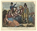 Black-eyed Sue and Sweet Poll of Plymouth, England, mourning their lovers who are soon to be transported to Botany Bay, 1792
 -
 Bicentennial Monument at Brighton-Le-Sands
 -
 Sydney Airport runway near Botany Bay beach


Notes
- ^ The strikethrough is in the Cook's original, reflecting a change of mind sometime after leaving the Bay in 1770
References
Citations
- ^ Fodnotefejl: Ugyldigt
<ref>-tag; ingen tekst er angivet for referencer med navnetroy - ^ Lawrence, Joan (1996). St. George Pictorial Memories: Rockdale, Kogarah, Hurstville. Crows Nest, NSW: Kingsclear Books. s. 3. ISBN 0-908272-45-6.
- ^ "A Short History of the City of Botany Bay". City of Botany Bay. 2012. Arkiveret fra originalen 16 juli 2012. Hentet 7 september 2012.
- ^ Cook, James; Hawkesworth, John (1773). "Entrance of Endeavour River in New South Wales. Botany Bay in New South Wales" (Kort). David Rumsey Historical Map Collection. State Library of Queensland. Hentet 7 september 2012.
{{cite map}}: CS1-vedligeholdelse: Dato automatisk oversat (link) - ^ Wales, Geographical Name Board of New South. "Extract – Geographical Names Board of NSW". gnb.nsw.gov.au. Hentet 2016-11-07.
- ^ a b Beaglehole (ed.) 1968, p. ccix
- ^ Parker 2009, p.113
- ^ "Governor Phillip's Instructions 25 April 1787 (UK)". Museum of Australian Democracy. Hentet 24 november 2013.
{{cite web}}: CS1-vedligeholdelse: Dato automatisk oversat (link) - ^ Governor Phillip to Lord Sydney, 15 May 1788, cited in Britten (ed.) 1978, pp. 121–123
- ^ "Kurnell Peninsula: a guide to the plants, animals, ecology and landscapes". Sydney Metropolitan Catchment Management Authority. 2010. Hentet 7 januar 2013.
{{cite web}}: CS1-vedligeholdelse: Dato automatisk oversat (link) - ^ "Old & Abandoned Australia Public Group | Facebook". mbasic.facebook.com. Hentet 28 september 2020.
{{cite web}}: CS1-vedligeholdelse: Dato automatisk oversat (link) - ^ "Botany Bay Watch Project". Botanybaywatch.com.au. Arkiveret fra originalen 18 juli 2008.
{{cite web}}: CS1-vedligeholdelse: Dato automatisk oversat (link) - ^ "Marine Blue Groper". Botanybaywatch.com.au. Arkiveret fra originalen 19 juli 2008.
{{cite web}}: CS1-vedligeholdelse: Dato automatisk oversat (link) - ^ Schwartz, Larry (15 april 2011). "Blowing in, yet again". Sydney Morning Herald. FairFax Media. Hentet 6 september 2018.
{{cite news}}: CS1-vedligeholdelse: Dato automatisk oversat (link) - ^ "Botany Bay". Runescape. Jagex Ltd. 26 september 2012. Hentet 6 september 2018.
{{cite web}}: CS1-vedligeholdelse: Dato automatisk oversat (link) - ^ Senior, Tom (4 maj 2016). "Runescape puts botters on trial in Botany Bay and lets players decide their fate". PC Gamer. Future US, Inc. Hentet 6 september 2018.
{{cite journal}}: CS1-vedligeholdelse: Dato automatisk oversat (link)
Works cited
- Beaglehole, J.C., red. (1968). The Journals of Captain James Cook on His Voyages of Discovery, vol. I:The Voyage of the Endeavour 1768–1771. Cambridge University Press. OCLC 223185477.
{{cite book}}: Cite har en ukendt tom parameter:|month=(hjælp)
Further reading
- Britton, Alex R., red. (1978). Historical records of New South Wales. Vol. 1, part 2. Phillip, 1783–1792. Lansdown Slattery & Co. s. 56. OCLC 219911274.
{{cite book}}: Cite har en ukendt tom parameter:|month=(hjælp) - Forster, George (2008). Allgemeines historisches Taschenbuch, oder, Abriss der merkwuridgsten neuen Welt Begebenheiten enthaltend fur 1787 [Neuholland und die brittische Colonie in Botany-Bay/New Holland and the British colony at Botany Bay] (German). Robert J. King, translator. Canberra: National Library of Australia.
{{cite book}}: CS1-vedligeholdelse: Ukendt sprog (link) - Tench, Watkin (2006). Anacharsis (red.). Le texte fondateur de l'Australie, récit de voyage d'un capitaine de la First Fleet durant l'Expédition à Botany Bay (French). preface by Merle, d'Isabelle. s. 320. ISBN 2-914777-30-2. Arkiveret fra originalen 25 november 2006. Hentet 24 maj 2011.
{{cite book}}: CS1-vedligeholdelse: Ukendt sprog (link) - . Falkirk: T. Johnston. 1798.
External links
| Wikisource har originalt kildemateriale relateret til denne artikel: |
| Wikivoyage har rejseinformationer relateret til: |
- "Georges River catchment" (map). Office of Environment and Heritage. Government of New South Wales.
- NSW Environment & Heritage webpage
- Irish Examiner article concerning penal colony
- Joanne Sippel (2013). "Booralee fishing town". Dictionary of Sydney. Dictionary of Sydney Trust. Hentet 6 oktober 2015.
{{cite web}}: CS1-vedligeholdelse: Dato automatisk oversat (link)
Skabelon:1stVoyageCookAus Skabelon:Waterways of Sydney Skabelon:Bays of New South Wales