
Bruger:Brol/sandkasse: Forskelle mellem versioner
Brol (diskussion | bidrag) No edit summary |
Brol (diskussion | bidrag) No edit summary |
||
| Linje 25: | Linje 25: | ||
|Navn = Botany Bay |
|Navn = Botany Bay |
||
|Billede = Sydney SPOT 1210.jpg |
|Billede = Sydney SPOT 1210.jpg |
||
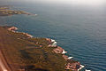
|Tekst = Luftfoto af det sydøstlige [[Sydney]] med Botany Bay. |
|Tekst = Luftfoto af det sydøstlige [[Sydney]] med Botany Bay. De to stykker land, der stikker ud i bugten er landingsbaner for [[Sydney Airport]]. |
||
De to stykker land, der stikker ud i bugten er landingsbaner for [[Sydney Airport]]. |
|||
|Land = New South Wales, Australien |
|Land = New South Wales, Australien |
||
|Kommuner = |
|Kommuner = |
||
| Linje 70: | Linje 69: | ||
=== British history=== |
=== British history=== |
||
[[File:Midhsipman Isaac Smith.jpg|thumb|left|[[Isaac Smith (Royal Navy officer)|Isaac Smith]] became the first European to set foot on eastern Australian soil, Cook telling him "Jump out, Isaac" as the ship's boat touched the shore at Botany Bay.]] |
[[File:Midhsipman Isaac Smith.jpg|thumb|left|[[Isaac Smith (Royal Navy officer)|Isaac Smith]] became the first European to set foot on eastern Australian soil, Cook telling him "Jump out, Isaac" as the ship's boat touched the shore at Botany Bay.]] |
||
[[File:SLNSW 826105 Botany Bay New South Wales ca 1789 watercolour by Charles Gore.jpg|thumb |
[[File:SLNSW 826105 Botany Bay New South Wales ca 1789 watercolour by Charles Gore.jpg|thumb|upright=1.52|''Botany Bay'', 1788, akvarel af [[Charles Gore (artist)|Charles Gore]]]] |
||
[[James Cook|Løjtnant James Cook]] gik i land søndag 29. april 1770 på Silver Beach ved [[Kurnell, New South Wales|Kurnell]] i den sydlige del af Botany Bay. Cook sejlede med sit skib [[HMS Endeavour|HMS ''Endeavour'']] fra syd mod nord langs den australske kyst. Det var første gang, han gik i land på østkysten, og det var indledningen på [[Storbritannien|Storbritanniens]] interesse for Australien og en mulig kolonisering af det nye kontinent.<ref>{{cite map |url=http://www.davidrumsey.com/luna/servlet/detail/RUMSEY~8~1~24019~870064 |title=Entrance of Endeavour River in New South Wales. Botany Bay in New South Wales |publisher=State Library of Queensland |work=David Rumsey Historical Map Collection |accessdate=7. september 2012 |author1=Cook, James |author2=Hawkesworth, John |year=1773}}</ref> Til at begynde med blev navnet ''Stingrays Harbour'' (Rokkehavnen) brugt af Cook og andre medlemmer af ekspeditionen efter de [[rokker]], de fangede i bugten.<ref>{{Cite web|url=http://www.gnb.nsw.gov.au/place_naming/placename_search/extract?id=MnjLoesE|title=Extract – Geographical Names Board of NSW|last=Wales|first=Geographical Name Board of New South|website=gnb.nsw.gov.au|access-date=7. november 2016}}</ref> Navnet blev også brugt på et kort udarbejdet af det [[Admiralitetet|Britiske Admiralitet]].<ref name="Botany">Beaglehole (ed.) 1968, p. ccix</ref> Cook skriver i sin log 6. maj 1770: " |
[[James Cook|Løjtnant James Cook]] gik i land søndag 29. april 1770 på Silver Beach ved [[Kurnell, New South Wales|Kurnell]] i den sydlige del af Botany Bay. Cook sejlede med sit skib [[HMS Endeavour|HMS ''Endeavour'']] fra syd mod nord langs den australske kyst. Det var første gang, han gik i land på østkysten, og det var indledningen på [[Storbritannien|Storbritanniens]] interesse for Australien og en mulig kolonisering af det nye kontinent.<ref>{{cite map |url=http://www.davidrumsey.com/luna/servlet/detail/RUMSEY~8~1~24019~870064 |title=Entrance of Endeavour River in New South Wales. Botany Bay in New South Wales |publisher=State Library of Queensland |work=David Rumsey Historical Map Collection |accessdate=7. september 2012 |author1=Cook, James |author2=Hawkesworth, John |year=1773}}</ref> Til at begynde med blev navnet ''Stingrays Harbour'' (Rokkehavnen) brugt af Cook og andre medlemmer af ekspeditionen efter de [[rokker]], de fangede i bugten.<ref>{{Cite web|url=http://www.gnb.nsw.gov.au/place_naming/placename_search/extract?id=MnjLoesE|title=Extract – Geographical Names Board of NSW|last=Wales|first=Geographical Name Board of New South|website=gnb.nsw.gov.au|access-date=7. november 2016}}</ref> Navnet blev også senere brugt på et kort udarbejdet af det [[Admiralitetet|Britiske Admiralitet]].<ref name="Botany">Beaglehole (ed.) 1968, p. ccix</ref> Cook skriver i sin log 6. maj 1770: "Den store mængde af disse fisk inspirerede mig til at give den navnet Stingrays Harbour". Alligevel skrev Cook senere i den journal, han skrev på basis af sin log: "Den store mængde planter [[Joseph Banks|Mr. Banks]] og [[Daniel Solander|Dr. Solander]] fandt på dette sted inspirerede mig til at give den navnet <s>Botanist</s> Botany Bay"{{refn|group=note|The strikethrough is in the Cook's original, reflecting a change of mind sometime after leaving the Bay in 1770}}<ref name="Botany"/> (Botanikbugten). |
||
Botanikeren Joseph Banks blev senere en vigtig fortaler for, at Storbritannien skulle grundlægge en koloni i Botany Bay. Det blev næsten en realitet i 1788, da [[Arthur Phillip]] med [[HMS Supply (1759)|HMS ''Supply'']] sejlede ind i bugten 18. januar. Han havde kontakt med de indfødte fra [[Eora|Eora-stammen]], som virkede nysgerrige men mistænksomme over for de nytilkomne. To dage senere stødte de resterende skibe fra den [[Første Flåde]] til, for at grundlægge den planlagte straffekoloni. De vurderede dog, at bugten var uegnet til bosættelse, da der ikke var adgang til tilstrækkeligt drikkevand. Phillip var også bange for, at sumpene ved bugten ville give et usundt klima. Bugten var også åben og ubeskyttet, ligesom den var for lavvandet til at skibe kunne ankre op tæt på kysten, og endelig mente han, at jorden var for dårlig.<ref>Parker 2009, p.113</ref> |
|||
The area was studded with enormously strong trees. When the convicts tried to cut them down, their tools broke and the tree trunks had to be blasted out of the ground with gunpowder. The primitive huts built for the officers and officials quickly collapsed in rainstorms. Crucially, Phillip worried that his fledgling colony was exposed to attack from [[Aboriginal Australian|Aborigines]] or foreign powers. |
The area was studded with enormously strong trees. When the convicts tried to cut them down, their tools broke and the tree trunks had to be blasted out of the ground with gunpowder. The primitive huts built for the officers and officials quickly collapsed in rainstorms. Crucially, Phillip worried that his fledgling colony was exposed to attack from [[Aboriginal Australian|Aborigines]] or foreign powers. Selvom han havde instrukser om at grundlægge en koloni i Botany Bay, havde han autorisation til at etablere den et andet sted om nødvendigt.<ref name="Museum of Australian Democracy">{{cite web |
||
| title = Governor Phillip's Instructions 25 April 1787 (UK) |
| title = Governor Phillip's Instructions 25 April 1787 (UK) |
||
| url = http://foundingdocs.gov.au/item-sdid-68.html |
| url = http://foundingdocs.gov.au/item-sdid-68.html |
||
| publisher = Museum of Australian Democracy |
| publisher = Museum of Australian Democracy |
||
| accessdate = 24 November 2013 |
| accessdate = 24 November 2013 |
||
}}</ref> |
}}</ref> Phillip besluttede derfor at flytte til den fremragende naturhavn [[Port Jackson]] få kilometer længere mod nord.<ref>Governor Phillip to Lord Sydney, 15 May 1788, cited in Britten (ed.) 1978, pp. 121–123</ref> |
||
| Linje 95: | Linje 94: | ||
[[File:La Perouse 3.JPG|thumb|Monument at [[La Perouse, New South Wales|La Perouse]].]] |
[[File:La Perouse 3.JPG|thumb|Monument at [[La Perouse, New South Wales|La Perouse]].]] |
||
[[Sydney Airport]], |
[[Sydney Airport]], Australiens travleste lufthavn, ligger ud til den nordvestlige del af Botany Bay. To af dens landingsbaner går ud i bugten. Efter 2. verdenskrig blev udmundingen af [[Cooks River]] flyttet to kilometer mod vest for at øre plads til en udvidelse af lufthavnen. Land blev indvundet fra bugten for at udvide den første nord-syd landingsbane og for at bygge en ny parallel landingsbane. |
||
Den første [[containerterminal]] ved Port Botany, øst for lufthavnen, blev færdiggjort i 1979 og er Sydneys største. Endnu en containerterminal blev bygget i 1980'erne. Der er tankfaciliteter både i den nordlige og sydlige del af bugten . En tredje containerterminal åbnede i 2011. |
|||
The first container terminal at Port Botany, east of the airport, was completed during the 1970s and is the largest [[container terminal]] in Sydney. A second container terminal was completed during the 1980s and bulk liquid storage facilities are located on the northern and southern edge of the bay. A third container terminal was completed in 2011. |
|||
The land around the headlands of the bay is protected by the [[National Parks and Wildlife Service (New South Wales)|National Parks and Wildlife Service]] as [[Kamay Botany Bay National Park]]. On the northern side of the mouth of the bay is the historic site of La Perouse, and to the south is Kurnell. Despite its relative isolation, the southern shore of the bay is |
The land around the headlands of the bay is protected by the [[National Parks and Wildlife Service (New South Wales)|National Parks and Wildlife Service]] as [[Kamay Botany Bay National Park]]. On the northern side of the mouth of the bay is the historic site of La Perouse, and to the south is Kurnell. Despite its relative isolation, the southern shore of the bay is domineret af en usædvanlig blanding af uberørt natur og tung industri som afsaltningsanlægget [[Kurnell Desalination Plant]], [[Kurnell Terminal|Caltex Fuel Terminal]], spildevandsanlæg og nedlagte sandgravningsanlæg.<ref name=scma>{{cite web |title=Kurnell Peninsula: a guide to the plants, animals, ecology and landscapes |accessdate=7. januar 2013 |url=http://sydney.cma.nsw.gov.au/index.php?option=com_remository&Itemid=51&func=download&id=549&chk=5115e53218b24f9cc44e7a81fdff0449&no_html=1 |publisher=Sydney Metropolitan Catchment Management Authority |year=2010}}</ref> On the southern side of the bay a section of water has been fenced off under the authority of the National Parks and Wildlife Service at [[Towra Point Nature Reserve|Towra Point]] for environmental conservation purposes. |
||
Vestkysten af bugten har flere strande, bl.a. [[Lady Robinsons Beach]], og er tæt bebygget. |
|||
Der er også en række [[Bunker|bunkere]] omkring Botany Bay. De blev bygget af militæret under [[2. verdenskrig]] og står der stadig. <ref>{{Cite web|url=https://mbasic.facebook.com/groups/795587077160341?view=permalink&id=3193105024075189&refid=7&_ft_=qid.6841522973855662507:mf_story_key.-5327898481503178466:group_id.795587077160341:top_level_post_id.3193105024075189:content_owner_id_new.536211023:src.22:photo_attachments_list.%5B10157256627091024,10157256627141024,10157256627216024,10157256627296024,10157256627376024%5D:photo_id.10157256627091024:story_location.5:story_attachment_style.album:view_time.1592916197:filter.h_nor&__tn__=*W-R|title=Old & Abandoned Australia Public Group | Facebook|website=mbasic.facebook.com|accessdate=28. september 2020}}</ref> |
|||
==Marine life== |
==Marine life== |
||
Versionen fra 22. okt. 2020, 20:38
| Botany Bay | |
|---|---|
 Luftfoto af det sydøstlige Sydney med Botany Bay. De to stykker land, der stikker ud i bugten er landingsbaner for Sydney Airport. | |
| Overblik | |
| Land | New South Wales, Australien |
| Tilløb | Georges River, Cooks River |
| Afvandingsareal | 54,9 km2 |
| Overfladeareal | 39,6 km2 |
| Maks. dybde | 11,4 meter |
| Oversigtskort | |

Botany Bay eller Botanybugten er en havbugt[1] ud til det Tasmanske Hav i New South Wales i Australien, 13 kilometer syd for centrum af Sydney. To floder løber ud i bugten: Georges River ved Taren Point og Cooks River ved Kyeemagh. Bugten har et areal på næsten 40 km2. Åbningen mod havet ligger mellem de to forstæder La Perouse og Kurnell. Det nordlige forbjerg ved bugtens åbning er Cape Banks og i syd hedder det ydre forbjerg Cape Solander og det indre Sutherland Point. Alle tre er navngivet efter medlemmer af James Cooks ekspedition, der 29. april 1770 gik i land i Botany Bay, som de første europæere på den australske østkyst.
Til trods for at bugten er relativt lavvandet, fungerer den som Sydneys vigtigste fragthavn. Havnen ligger ved Port Botany i den nordøstlige del af bugten tæt på Australiens største lufthavn, Sydney Airport, som har to landingsbaner, der delvist er anlagt ud i bugten. Botany Bay National Park ligger på begge sider af åbningen mod havet.
Historie
Der er arkæologiske spor efter en aboriginsk bosættelse ved Botany Bay for 5.000 år siden. Før briternes ankomst var området omkring bugten beboet af stammerne Eora mod nord, Tharawal mod syd og Dharug mod vest. Bidjigal-klanen, som tilhørte Dharug eller muligvis Eora, boede mellem Cooks River og Georges River. På de sydlige bredder boede Gweagal, som tilhørte Tharawal,[2] og på de nordlige bredder boede Kameygal-klanen, som tilhørte Eora.[3]
British history


Løjtnant James Cook gik i land søndag 29. april 1770 på Silver Beach ved Kurnell i den sydlige del af Botany Bay. Cook sejlede med sit skib HMS Endeavour fra syd mod nord langs den australske kyst. Det var første gang, han gik i land på østkysten, og det var indledningen på Storbritanniens interesse for Australien og en mulig kolonisering af det nye kontinent.[4] Til at begynde med blev navnet Stingrays Harbour (Rokkehavnen) brugt af Cook og andre medlemmer af ekspeditionen efter de rokker, de fangede i bugten.[5] Navnet blev også senere brugt på et kort udarbejdet af det Britiske Admiralitet.[6] Cook skriver i sin log 6. maj 1770: "Den store mængde af disse fisk inspirerede mig til at give den navnet Stingrays Harbour". Alligevel skrev Cook senere i den journal, han skrev på basis af sin log: "Den store mængde planter Mr. Banks og Dr. Solander fandt på dette sted inspirerede mig til at give den navnet Botanist Botany Bay"[note 1][6] (Botanikbugten).
Botanikeren Joseph Banks blev senere en vigtig fortaler for, at Storbritannien skulle grundlægge en koloni i Botany Bay. Det blev næsten en realitet i 1788, da Arthur Phillip med HMS Supply sejlede ind i bugten 18. januar. Han havde kontakt med de indfødte fra Eora-stammen, som virkede nysgerrige men mistænksomme over for de nytilkomne. To dage senere stødte de resterende skibe fra den Første Flåde til, for at grundlægge den planlagte straffekoloni. De vurderede dog, at bugten var uegnet til bosættelse, da der ikke var adgang til tilstrækkeligt drikkevand. Phillip var også bange for, at sumpene ved bugten ville give et usundt klima. Bugten var også åben og ubeskyttet, ligesom den var for lavvandet til at skibe kunne ankre op tæt på kysten, og endelig mente han, at jorden var for dårlig.[7]
The area was studded with enormously strong trees. When the convicts tried to cut them down, their tools broke and the tree trunks had to be blasted out of the ground with gunpowder. The primitive huts built for the officers and officials quickly collapsed in rainstorms. Crucially, Phillip worried that his fledgling colony was exposed to attack from Aborigines or foreign powers. Selvom han havde instrukser om at grundlægge en koloni i Botany Bay, havde han autorisation til at etablere den et andet sted om nødvendigt.[8] Phillip besluttede derfor at flytte til den fremragende naturhavn Port Jackson få kilometer længere mod nord.[9]
Although the penal settlement was almost immediately shifted to Sydney Cove, for some time in Britain transportation to "Botany Bay" was a metonym for transportation to any of the Australian penal settlements.
On the morning of 24 January the French exploratory expedition of Jean-François de Galaup, comte de Lapérouse was seen outside Botany Bay. On 26 January, the Supply left the bay to move up to Port Jackson and anchor in Sydney Cove. On the afternoon of 26 January, the remaining ships of First Fleet arrived at Sydney Cove. In 1789, Captain John Hunter surveyed Botany Bay after returning from the Cape of Good Hope, trading for grain. The good supply of fresh water in the area led to the expansion of its population in the 19th century.
The western shore of Botany Bay remained in its virgin state for almost fifty years after the initial settlement of Sydney Town. Land access to the area was difficult until a route from the west was established via Canterbury. As this route developed it became known as Illawarra Road, which is still one of the main access routes to the south-eastern suburbs of Sydney. The land nearer to this crossing of Cooks River was cleared and settled quite early in the infancy of the new colony.
Landmarks

Sydney Airport, Australiens travleste lufthavn, ligger ud til den nordvestlige del af Botany Bay. To af dens landingsbaner går ud i bugten. Efter 2. verdenskrig blev udmundingen af Cooks River flyttet to kilometer mod vest for at øre plads til en udvidelse af lufthavnen. Land blev indvundet fra bugten for at udvide den første nord-syd landingsbane og for at bygge en ny parallel landingsbane.
Den første containerterminal ved Port Botany, øst for lufthavnen, blev færdiggjort i 1979 og er Sydneys største. Endnu en containerterminal blev bygget i 1980'erne. Der er tankfaciliteter både i den nordlige og sydlige del af bugten . En tredje containerterminal åbnede i 2011.
The land around the headlands of the bay is protected by the National Parks and Wildlife Service as Kamay Botany Bay National Park. On the northern side of the mouth of the bay is the historic site of La Perouse, and to the south is Kurnell. Despite its relative isolation, the southern shore of the bay is domineret af en usædvanlig blanding af uberørt natur og tung industri som afsaltningsanlægget Kurnell Desalination Plant, Caltex Fuel Terminal, spildevandsanlæg og nedlagte sandgravningsanlæg.[10] On the southern side of the bay a section of water has been fenced off under the authority of the National Parks and Wildlife Service at Towra Point for environmental conservation purposes.
Vestkysten af bugten har flere strande, bl.a. Lady Robinsons Beach, og er tæt bebygget.
Der er også en række bunkere omkring Botany Bay. De blev bygget af militæret under 2. verdenskrig og står der stadig. [11]
Marine life
Botany Bay has a diverse marine population, and the area around its entrance is a popular area for scuba diving. In recent times,[hvornår?] the Botany Bay Watch Project[12] has begun with volunteers assisting to monitor and protect the Bay Catchment and its unique marine life.
The world's largest population of weedy sea dragon ever surveyed is found at the 'Steps' dive site, on the Kurnell side of the Botany Bay National Park. Weedy sea dragons are just one of hundreds of territorial marine creatures found within Botany Bay. The eastern blue groper[13] is the state fish of New South Wales; it is very tame and is commonly found following divers along the shoreline of Botany Bay.
In popular culture
- Despite the move to Sydney Cove, for many years the Australian penal colony would be referred to as "Botany Bay" in England, and in ballads such as "The Fields of Athenry," by Irish songwriter Pete St. John.
- A song named "Botany Bay" has been performed as a folk and music hall song since the 1890s, based on older tunes. It also refers to the penal colony.
- A song entitled "The Shores of Botany Bay" was written by Brian Warfield and recorded by The Wolfe Tones in the early 1970s. This satirical song deals with a group of Irishmen volunteering for the transportation process in the hopes of finding wealth in Australia.
- A song titled "Bound for Botany Bay" is featured on Irish singer-songwriter and guitarist John Doyle's album Shadow and Light.
- In the 1941 historical novel Botany Bay by Charles Nordhoff and James Norman Hall, the protagonist, after various adventures and misadventures in England, gets transported to Botany Bay. A movie based on the book starring Alan Ladd and James Mason was shot in 1953.
- The song "Jim Jones at Botany Bay" (aka "Jim Jones") is about a prisoner who is going to Botany Bay. The song has been recorded several times, including a well-known version by Bob Dylan, and sung by Jennifer Jason Leigh in The Hateful Eight.[14]
- SS Botany Bay was the name of the spaceship on which Khan Noonien Singh and his followers escaped from Earth in Star Trek: The Original Series and Star Trek II: The Wrath of Khan.
- In the play and musical Sweeney Todd: The Demon Barber of Fleet Street, Benjamin Barker, the man who would become Sweeney Todd, was transported to Botany Bay for life on a false charge by Judge Turpin.
- In the MMORPG Runescape, Botany Bay is the name of a location in-game where players can view other players' accounts being penalized for using "bots", computer macros, to cheat.[15][16]
See also
Gallery
-
-
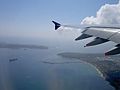 The mouth of Botany Bay from the air
 -
 Botany Bay, view from Kurnell
 -
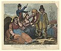 Black-eyed Sue and Sweet Poll of Plymouth, England, mourning their lovers who are soon to be transported to Botany Bay, 1792
 -
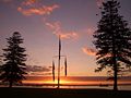
 Bicentennial Monument at Brighton-Le-Sands
 -
 Sydney Airport runway near Botany Bay beach


Notes
- ^ The strikethrough is in the Cook's original, reflecting a change of mind sometime after leaving the Bay in 1770
References
Citations
- ^ Fodnotefejl: Ugyldigt
<ref>-tag; ingen tekst er angivet for referencer med navnetroy - ^ Lawrence, Joan (1996). St. George Pictorial Memories: Rockdale, Kogarah, Hurstville. Crows Nest, NSW: Kingsclear Books. s. 3. ISBN 0-908272-45-6.
- ^ "A Short History of the City of Botany Bay". City of Botany Bay. 2012. Arkiveret fra originalen 16. juli 2012. Hentet 7. september 2012.
- ^ Cook, James; Hawkesworth, John (1773). "Entrance of Endeavour River in New South Wales. Botany Bay in New South Wales" (Kort). David Rumsey Historical Map Collection. State Library of Queensland. Hentet 7. september 2012.
- ^ Wales, Geographical Name Board of New South. "Extract – Geographical Names Board of NSW". gnb.nsw.gov.au. Hentet 7. november 2016.
- ^ a b Beaglehole (ed.) 1968, p. ccix
- ^ Parker 2009, p.113
- ^ "Governor Phillip's Instructions 25 April 1787 (UK)". Museum of Australian Democracy. Hentet 24 november 2013.
{{cite web}}: CS1-vedligeholdelse: Dato automatisk oversat (link) - ^ Governor Phillip to Lord Sydney, 15 May 1788, cited in Britten (ed.) 1978, pp. 121–123
- ^ "Kurnell Peninsula: a guide to the plants, animals, ecology and landscapes". Sydney Metropolitan Catchment Management Authority. 2010. Hentet 7. januar 2013.
- ^ "Old & Abandoned Australia Public Group | Facebook". mbasic.facebook.com. Hentet 28. september 2020.
- ^ "Botany Bay Watch Project". Botanybaywatch.com.au. Arkiveret fra originalen 18. juli 2008.
- ^ "Marine Blue Groper". Botanybaywatch.com.au. Arkiveret fra originalen 19. juli 2008.
- ^ Schwartz, Larry (15. april 2011). "Blowing in, yet again". Sydney Morning Herald. FairFax Media. Hentet 6. september 2018.
- ^ "Botany Bay". Runescape. Jagex Ltd. 26. september 2012. Hentet 6. september 2018.
- ^ Senior, Tom (4. maj 2016). "Runescape puts botters on trial in Botany Bay and lets players decide their fate". PC Gamer. Future US, Inc. Hentet 6. september 2018.
Works cited
- Beaglehole, J.C., red. (1968). The Journals of Captain James Cook on His Voyages of Discovery, vol. I:The Voyage of the Endeavour 1768–1771. Cambridge University Press. OCLC 223185477.
{{cite book}}: Cite har en ukendt tom parameter:|month=(hjælp)
Further reading
- Britton, Alex R., red. (1978). Historical records of New South Wales. Vol. 1, part 2. Phillip, 1783–1792. Lansdown Slattery & Co. s. 56. OCLC 219911274.
{{cite book}}: Cite har en ukendt tom parameter:|month=(hjælp) - Forster, George (2008). Allgemeines historisches Taschenbuch, oder, Abriss der merkwuridgsten neuen Welt Begebenheiten enthaltend fur 1787 [Neuholland und die brittische Colonie in Botany-Bay/New Holland and the British colony at Botany Bay] (German). Robert J. King, translator. Canberra: National Library of Australia.
{{cite book}}: CS1-vedligeholdelse: Ukendt sprog (link) - Tench, Watkin (2006). Anacharsis (red.). Le texte fondateur de l'Australie, récit de voyage d'un capitaine de la First Fleet durant l'Expédition à Botany Bay (French). preface by Merle, d'Isabelle. s. 320. ISBN 2-914777-30-2. Arkiveret fra originalen 25. november 2006. Hentet 24. maj 2011.
{{cite book}}: CS1-vedligeholdelse: Ukendt sprog (link) - . Falkirk: T. Johnston. 1798.
External links
| Wikisource har originalt kildemateriale relateret til denne artikel: |
| Wikivoyage har rejseinformationer relateret til: |
- "Georges River catchment" (map). Office of Environment and Heritage. Government of New South Wales.
- NSW Environment & Heritage webpage
- Irish Examiner article concerning penal colony
- Joanne Sippel (2013). "Booralee fishing town". Dictionary of Sydney. Dictionary of Sydney Trust. Hentet 6. oktober 2015.