
Fil:LINE21.jpg
Størrelse af denne forhåndsvisning: 800 × 552 pixels. Andre opløsninger: 320 × 221 pixels | 640 × 442 pixels | 1.000 × 690 pixels.
Fuld opløsning (1.000 × 690 billedpunkter, filstørrelse: 102 KB, MIME-type: image/jpeg)
|
|
Denne fil er fra Wikimedia Commons. Beskrivelsen af filen fra Commons er gengivet nedenfor. |
Beskrivelse
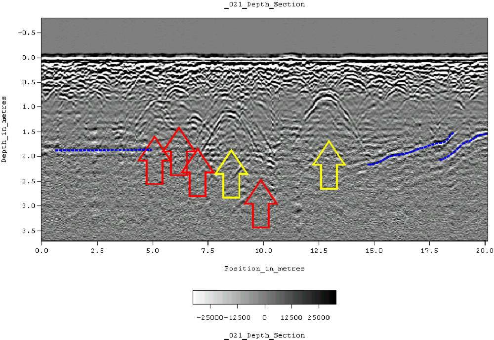
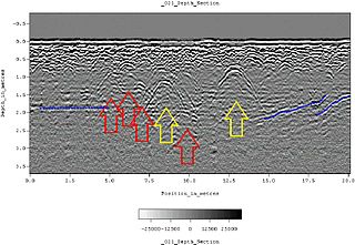
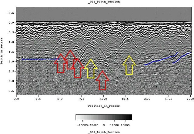
| Beskrivelse | Ground-penetrating radar depth section (profile) collected on an historic cemetery in Alabama, USA. Yellow arrows indicate very distinct reflections, probably associated with human burials. "hyperbolic" reflections, appearing as an inverted U, are typically associated with discrete objects. Less distinct hyperbolic reflections are indicated by red arrows. dashed blue lines indicate horizontal and sloping reflectors, probably bedrock. The many smaller reflections near the surface are likely to be caused by tree roots. Because of the nature of the site, subsurface testing was not conducted, but these interpretations are supported by surface indications (grave markers and depressions) and with line-to-line patterning within the GPR data. |
| Dato | 11. juni 2007 (original upload date) |
| Kilde | Transferred from en.wikipedia to Commons. |
| Forfatter | Tapatio at engelsk Wikipedia |
Licensering
| Dette værk er blevet udgivet som offentlig ejendom af dets skaber, Tapatio at engelsk Wikipedia. Dette gælder i hele verden. I nogle lande er dette ikke juridisk muligt. I så fald: Tapatio giver enhver ret til at anvende dette værk til ethvert formål, uden nogen restriktioner, medmindre sådanne restriktioner er påkrævede ved lov. |
Oprindelig oplægningslog
The original description page was here. All following user names refer to en.wikipedia.
- 2007-06-11 05:16 Tapatio 1000×690×8 (104839 bytes) {{PD-self}}
- 2007-06-11 04:49 Tapatio 1000×690×8 (104839 bytes) Ground-penetrating radar depth section (profile) collected on an historic cemetery in Alabama, USA. Yellow arrows indicate very distinct reflections, probably associated with human burials. "Parabolic" reflections, appearing as an inverted U, are typicall
Filhistorik
Klik på en dato/tid for at se filen som den så ud på det tidspunkt.
| Dato/tid | Miniaturebillede | Dimensioner | Bruger | Kommentar | |
|---|---|---|---|---|---|
| nuværende | 17. okt. 2007, 21:02 | | 1.000 × 690 (102 KB) | Conscious | full resolution |
| 2. okt. 2007, 21:22 |  | 800 × 552 (105 KB) | Rosarinagazo | Ground-penetrating radar depth section (profile) collected on an historic cemetery in Alabama, USA. Yellow arrows indicate very distinct reflections, probably associated with human burials. "hyperbolic" reflections, appearing as an inverted U, are typical |
Filanvendelse
Den følgende side bruger denne fil:
Global filanvendelse
Følgende andre wikier anvender denne fil:
- Anvendelser på ar.wikipedia.org
- Anvendelser på ca.wikipedia.org
- Anvendelser på de.wikipedia.org
- Anvendelser på el.wikipedia.org
- Anvendelser på en.wikipedia.org
- Anvendelser på es.wikipedia.org
- Anvendelser på et.wikipedia.org
- Anvendelser på fr.wikipedia.org
- Anvendelser på he.wikipedia.org
- Anvendelser på ml.wikipedia.org
- Anvendelser på nl.wikipedia.org
- Anvendelser på nn.wikipedia.org
- Anvendelser på no.wikipedia.org
- Anvendelser på pl.wikipedia.org
- Anvendelser på pt.wikipedia.org
- Anvendelser på sk.wikipedia.org
- Anvendelser på vi.wikipedia.org
- Anvendelser på zh.wikipedia.org