
Fil:LocationSouthAfrica-1990.png
LocationSouthAfrica-1990.png (250 × 115 billedpunkter, filstørrelse: 5 KB, MIME-type: image/png)
|
|
Denne fil er fra Wikimedia Commons. Beskrivelsen af filen fra Commons er gengivet nedenfor. |

|
En vektorversion af dette billede (SVG) er tilgængelig. Det bør bruges i stedet for punktgrafikbilledet når det er fordelagtigt.
File:LocationSouthAfrica-1990.png → File:South Africa in its region (1990).svg
For mere information om vektorgrafik: Læs om overgangen til SVG på Commons. Se også information om MediaWikis understøttelse af SVG-billeder. |
.svg) |
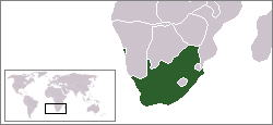
Beskrivelse
A locator map of South Africa showing en:Walvis Bay. This locator map is intended for South African articles taking place before the transfer of Walvis Bay to Namibia in 1994. The orginal map is by Vardion. Since that map is PD, this one is well.
Licensering
| Dette værk er blevet udgivet som offentlig ejendom af dets skaber, Hoshie. Dette gælder i hele verden. I nogle lande er dette ikke juridisk muligt. I så fald: |
Filhistorik
Klik på en dato/tid for at se filen som den så ud på det tidspunkt.
| Dato/tid | Miniaturebillede | Dimensioner | Bruger | Kommentar | |
|---|---|---|---|---|---|
| nuværende | 17. dec. 2009, 09:26 | | 250 × 115 (5 KB) | Hoshie | Reverted to version as of 03:34, 16 August 2006 rv, Nambia itself wasn't a part of S. Africa |
| 2. dec. 2008, 20:37 |  | 250 × 115 (5 KB) | ChrisDHDR | South Africa included Namibia at the time | |
| 16. aug. 2006, 05:34 |  | 250 × 115 (5 KB) | Hoshie | == Summary == A locator map of South Africa showing en:Walvis Bay. This locator map is intended for South African articles taking place before the transfer of Walvis Bay to Nambia in 1994. The orginal map is by [[Us |
Filanvendelse
Der er ingen sider der bruger denne fil.