
Fil:Luzon Strait n7184.jpg

Størrelse af denne forhåndsvisning: 318 × 598 pixels. Andre opløsninger: 127 × 240 pixels | 542 × 1.020 pixels.
Fuld opløsning (542 × 1.020 billedpunkter, filstørrelse: 77 KB, MIME-type: image/jpeg)
|
|
Denne fil er fra Wikimedia Commons. Beskrivelsen af filen fra Commons er gengivet nedenfor. |
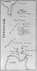
| Beskrivelse | Old map of the Luzon Strait (not labeled), including the Bashi Channel, between Orchid Island (Botel Tobago on the map) of Taiwan and the Batan Islands of the Philippines. Names may be out of date. Japanese caption: "Islands between Taiwan and Luzon". | |||||
| Dato | Ukendt dato | |||||
| Kilde |
From digital archive of the University of Tokyo. [1] Cropped by a-giâu. |
|||||
| Forfatter | anthropologist Torii Ryūzō (1870-1953) | |||||
| Tilladelse (Genbrug af denne fil) |
|


Filhistorik
Klik på en dato/tid for at se filen som den så ud på det tidspunkt.
| Dato/tid | Miniaturebillede | Dimensioner | Bruger | Kommentar | |
|---|---|---|---|---|---|
| nuværende | 12. nov. 2004, 01:30 | | 542 × 1.020 (77 KB) | A-giâu | Old map of the Luzon Strait,(not labeled), including the Bashi Channel, between Orchid Island (Botel Tobago in the map) of Taiwan and the Batanes of the Philippines. Names may be out of date. From digital archive of the Universit |
Filanvendelse
Den følgende side bruger denne fil:
Global filanvendelse
Følgende andre wikier anvender denne fil:
- Anvendelser på ar.wikipedia.org
- Anvendelser på ast.wikipedia.org
- Anvendelser på az.wikipedia.org
- Anvendelser på bcl.wikipedia.org
- Anvendelser på be.wikipedia.org
- Anvendelser på ca.wikipedia.org
- Anvendelser på ceb.wikipedia.org
- Anvendelser på cs.wikipedia.org
- Anvendelser på de.wikipedia.org
- Anvendelser på en.wikipedia.org
- Anvendelser på es.wikipedia.org
- Anvendelser på eu.wikipedia.org
- Anvendelser på fa.wikipedia.org
- Anvendelser på fr.wikipedia.org
- Anvendelser på he.wikipedia.org
- Anvendelser på hi.wikipedia.org
- Anvendelser på id.wikipedia.org
- Anvendelser på ilo.wikipedia.org
- Anvendelser på it.wikipedia.org
- Anvendelser på ja.wikipedia.org
- Anvendelser på ko.wikipedia.org
- Anvendelser på lt.wikipedia.org
- Anvendelser på mk.wikipedia.org
- Anvendelser på nl.wikipedia.org
- Anvendelser på no.wikipedia.org
Vis flere globale anvendelser af denne fil.