
Fil:Palestine Distribution of Population 1947 UN map no 93(b).jpeg
Fuld opløsning (591 × 1.078 billedpunkter, filstørrelse: 228 KB, MIME-type: image/jpeg)
|
|
Denne fil er fra Wikimedia Commons. Beskrivelsen af filen fra Commons er gengivet nedenfor. |
.jpeg?uselang=da)
Beskrivelse
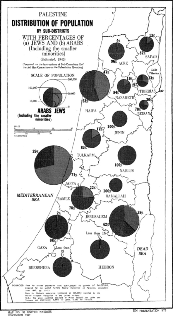
| Beskrivelse | Palestine Distribution of Population 1947 UN map no 93(b) |
| Dato | 13. august 2013 (upload date) |
| Kilde | United Nations Documents website |
| Forfatter | United Nations |
Licensering
| This image is a map derived from a United Nations map.
Unless stated otherwise, UN maps are to be considered in the public domain. This applies worldwide. UN maps are, in principle, open source material and you can use them in your work or for making your own map. UN requests however that you delete the UN name, logo and reference number upon any modification to the map. Content of your map will be your responsibility. You can state in your publication, if you wish, something like: based on UN map … (map name, map number, revision number and date). See: Geospatial Information Section. And: Geospatial, location data for a better world. |
 |
Filhistorik
Klik på en dato/tid for at se filen som den så ud på det tidspunkt.
| Dato/tid | Miniaturebillede | Dimensioner | Bruger | Kommentar | |
|---|---|---|---|---|---|
| nuværende | 13. aug. 2013, 16:11 | | 591 × 1.078 (228 KB) | Onceinawhile | Uploaded with Commons for iOS |
Filanvendelse
Den følgende side bruger denne fil:
Global filanvendelse
Følgende andre wikier anvender denne fil:
- Anvendelser på azb.wikipedia.org
- Anvendelser på en.wikipedia.org
- Anvendelser på fa.wikipedia.org
- Anvendelser på ja.wikipedia.org
- Anvendelser på ru.wikipedia.org
- Anvendelser på sd.wikipedia.org
.jpeg)