
Fil:Shetland Unst locator.svg

Size of this PNG preview of this SVG file: 315 × 599 pixels. Andre opløsninger: 126 × 240 pixels | 252 × 480 pixels | 404 × 768 pixels | 538 × 1.024 pixels | 1.077 × 2.048 pixels | 832 × 1.582 pixels.
Fuld opløsning (SVG fil, basisstørrelse 832 × 1.582 pixels, filstørrelse: 1,64 MB)
|
|
Denne fil er fra Wikimedia Commons. Beskrivelsen af filen fra Commons er gengivet nedenfor. |
| Beskrivelse |
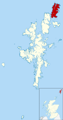
Map of the Shetland Islands, UK, with Unst highlighted. Equirectangular map projection on WGS 84 datum, with N/S stretched 200% Geographic limits:
|
| Dato | |
| Kilde | Ordnance Survey OpenData. Most data from Boundary-Line product. Lake data from Meridian 2 product. Inset derived from File:Scotland location map.svg by NordNordWest. |
| Forfatter | Nilfanion, created using Ordnance Survey data |
| Tilladelse (Genbrug af denne fil) |
Denne fil er udgivet under Creative Commons Kreditering-Del på samme vilkår 3.0 Ikke-porteret-licensen. Kreditering: Contains Ordnance Survey data © Crown copyright and database right
|
Filhistorik
Klik på en dato/tid for at se filen som den så ud på det tidspunkt.
| Dato/tid | Miniaturebillede | Dimensioner | Bruger | Kommentar | |
|---|---|---|---|---|---|
| nuværende | 2. sep. 2010, 12:15 | | 832 × 1.582 (1,64 MB) | Nilfanion | {{Information |Description=Map of the Shetland Islands, UK, with Unst highlighted. Equirectangular map projection on WGS 84 datum, with N/S stretched 200% Geographic limits: *West: 2.15W *East: 0.70W *North: 60.88N *Sou |
Filanvendelse
Der er ingen sider der bruger denne fil.
Global filanvendelse
Følgende andre wikier anvender denne fil: