
Fil:1776 Rennell - Dury Wall Map of Bihar and Bengal, India - Geographicus - BaharBengal-dury-1776.jpg

Fuld opløsning (9.106 × 6.000 billedpunkter, filstørrelse: 16,86 MB, MIME-type: image/jpeg)
|
|
Denne fil er fra Wikimedia Commons. Beskrivelsen af filen fra Commons er gengivet nedenfor. |
Beskrivelse
| Advarsel | Nogle browsere kan have problemer med visning af dette billede i fuld opløsning: Dette billede har et usædvanligt stort antal pixels og kan enten ikke loade ordentligt eller få browseren til at fryse. |
|---|
| Titel |
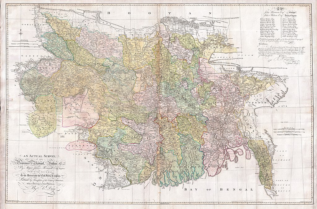
An Actual Survey, of the Provinces of Bengal, Bahar & c. by Major James Rennell Esq. Engineer to the Honorable the East India Company. Published by Permission of the Court of Directors from a Drawing in their Possession by A. Dury. |
|||||||||
| Beskrivelse |
English: An altogether spectacular wall sized map of those parts of Bengal and Bihar, India. Follows the course of the Ganges River from Varanasi (Benares) eastward to the Ganges Delta and the Bay of Bengal. Includes Varanasi (Benares), Dacca (Dahka, Bengladesh), and Patna among many other important Indian cities. Bounded on the north by the Himalaya Mountains and the border with Bhutan. One of the first accurate maps of the interior of India. Laid out from primary surveys done by James Rennell, the first modern cartographer to map the interior of India. Notes cities, markets, battlefields, fortresses, roads, rivers, offers political commentary, and features some geographical references. Elaborate title in the lower left quadrant. Upper right quadrant features a dedication and letter of thanks written by Andrew Dury, the publisher, to the board of the East India Company. This is the first edition of this rare map – 1776 – as published by Dury. Later editions were published by Sayer and Bennet and by Laurie and Whittle.
Another high quality digitisation is available at the David Rumsey Historical Map Collection: [1] This map was published by Laurie and Whittle, as mentioned in the description by Geographicus for the 1776 map, in 1794. Regions are demarcated in coloured outlines instead of filled colours. A higher quality digitisation than that of Geographicus. Contains parts that are missing at the central vertical fold in the Geographicus digitisation of the 1776 map. Viewable in online Flash viewer and downloadable in MrSID format. |
|||||||||
| Dato | (dated) | |||||||||
| Kilde |
The Bengal Atlas ??, Rennell, James, (1779 first edition)
|
|||||||||
| Skaber | ||||||||||
| Geotemporal data | ||||||||||
| Bounding box |
|
|||||||||
| Georeferencing | ||||||||||
| Archival data | ||||||||||
| Museumsnummer |
Geographicus link: BaharBengal-dury-1776 |
|||||||||
| Mål | højde: 39 in (99 cm); bredde: 59 in (149,8 cm) | |||||||||

|
This image has been assessed under the valued image criteria and is considered the most valued image on Commons within the scope: Old maps of Bengal from 1776 by Major James Rennell. You can see its nomination here. |
Licensering
|
Værket er også offentlig ejendom i lande og områder, hvor ophavsrettens længde er ophavsmandens levetid plus 100 år eller derunder. Dette værk er offentlig ejendom i Amerikas Forenede Stater (USA) fordi det blev udgivet (eller registreret hos U.S. Copyright Office) før 1 januar 1929. | |
| Denne fil er blevet identificeret som værende fri for kendte restriktioner under lov om ophavsret, herunder alle relaterede og tilstødende rettigheder. | |
Filhistorik
Klik på en dato/tid for at se filen som den så ud på det tidspunkt.
| Dato/tid | Miniaturebillede | Dimensioner | Bruger | Kommentar | |
|---|---|---|---|---|---|
| nuværende | 17. mar. 2011, 10:39 | | 9.106 × 6.000 (16,86 MB) | BotMultichill | {{subst:User:Multichill/Geographicus |link=http://www.geographicus.com/P/AntiqueMap/BaharBengal-dury-1776 |product_name=1776 Rennell - Dury Wall Map of Bihar and Bengal, India |map_title=An Actual Survey, of the Provinces of Bengal, Bahar & c. by Major Ja |
Filanvendelse
Der er ingen sider der bruger denne fil.
Global filanvendelse
Følgende andre wikier anvender denne fil:
- Anvendelser på ar.wikipedia.org
- Anvendelser på as.wikipedia.org
- Anvendelser på azb.wikipedia.org
- Anvendelser på bn.wikipedia.org
- Anvendelser på bn.wikisource.org
- Anvendelser på cs.wikipedia.org
- Anvendelser på el.wikipedia.org
- Anvendelser på en.wikipedia.org
- Anvendelser på es.wikipedia.org
- Anvendelser på fa.wikipedia.org
- Anvendelser på fr.wikipedia.org
- Anvendelser på hi.wikipedia.org
- Anvendelser på ja.wikipedia.org
- Anvendelser på ko.wikipedia.org
- Anvendelser på ml.wikipedia.org
- Anvendelser på mt.wikipedia.org
- Anvendelser på ne.wikipedia.org
- Anvendelser på nl.wikipedia.org
- Anvendelser på pnb.wikipedia.org
- Anvendelser på sa.wikipedia.org
Vis flere globale anvendelser af denne fil.