
Fil:215 Miles from Southport - geograph.org.uk - 515415.jpg
Der findes ingen højere opløsning af billedet
215_Miles_from_Southport_-_geograph.org.uk_-_515415.jpg (640 × 452 billedpunkter, filstørrelse: 79 KB, MIME-type: image/jpeg)
|
|
Denne fil er fra Wikimedia Commons. Beskrivelsen af filen fra Commons er gengivet nedenfor. |
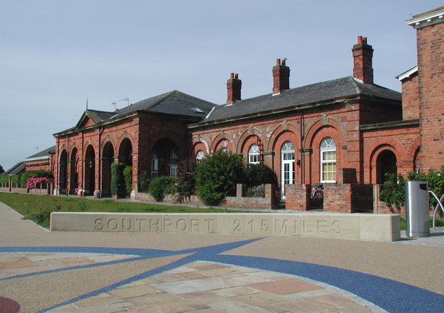
This is a photo of listed building number 1249389. |
Beskrivelse
| Beskrivelse |
English: 215 Miles from Southport, Hornsea, East Riding of Yorkshire, England. Part of the installation at the old Hornsea Railway Station marking the end of the Trans Pennine Trail. The trail which runs for 215 miles from Hornsea to Southport officially opened in September 2001 after twelve years of planning and development. There are actually three locations in Hornsea where the eastern end of the trail is marked: as well as this one there is a tall metallic sculpture on the seafront and also a small and rather dull concrete plinth outside Hornsea Leisure Centre on Sands Lane. In 1846 the York & North Midland Railway Co. was granted permission to build a railway line from Beverley to Hornsea, and in 1861 Joseph Armytage Wade promoted the building of a line from Hornsea to Hull and the Hull & Hornsea Railway Co. was formed. The line opened in 1864 with this station close to the sea and another at Hornsea Bridge at the junction of Southgate and Rolston Road. After little or no financial success the company merged with North Eastern Railway in 1866. The seafront terminus closed in 1964 and Hornsea Bridge Station the following year. Hornsea Bridge Station has been demolished and the buildings here at the terminus converted into housing. |
| Dato | |
| Kilde | From geograph.org.uk |
| Forfatter | Paul Glazzard |
| Tilladelse (Genbrug af denne fil) |
Creative Commons Attribution Share-alike license 2.0 |
| Kreditering (required by the license) | Paul Glazzard / 215 Miles from Southport / |
| Kameraposition | | Dette og andre billeder på deres position på: OpenStreetMap |
|---|
_heading:225.00&language=da)
| Objektposition | | Dette og andre billeder på deres position på: OpenStreetMap |
|---|
_heading:225.00&language=da)
Licensering

|
This image was taken from the Geograph project collection. See this photograph's page on the Geograph website for the photographer's contact details. The copyright on this image is owned by Paul Glazzard and is licensed for reuse under the Creative Commons Attribution-ShareAlike 2.0 license.
|
Denne fil er udgivet under Creative Commons Navngivelse – Del på samme vilkår 2.0 Generisk-licensen.
Kreditering: Paul Glazzard
- Du må frit:
- at dele – at kopiere, distribuere og overføre værket
- at remixe – at tilpasse værket
- Under følgende vilkår:
- kreditering – Du skal give passende kreditering, angive et link til licensen, og oplyse om der er foretaget ændringer. Du må gøre det på enhver fornuftig måde, men ikke på en måde der antyder at licensgiveren godkender dig eller din anvendelse.
- deling på samme vilkår – Hvis du bearbejder, ændrer eller bygger videre på dette værk, skal du distribuere dine bidrag under den samme eller en kompatibel licens som originalen.
Filhistorik
Klik på en dato/tid for at se filen som den så ud på det tidspunkt.
| Dato/tid | Miniaturebillede | Dimensioner | Bruger | Kommentar | |
|---|---|---|---|---|---|
| nuværende | 5. feb. 2011, 13:49 | | 640 × 452 (79 KB) | GeographBot | == {{int:filedesc}} == {{Information |description={{en|1=215 Miles from Southport Part of the installation at the old Hornsea Railway Station marking the end of the Trans Pennine Trail. The trail which runs for 215 miles from Hornsea to Southport official |
Filanvendelse
Der er ingen sider der bruger denne fil.
Global filanvendelse
Følgende andre wikier anvender denne fil: