
Fil:Americas Köppen Map.png

Størrelse af denne forhåndsvisning: 483 × 599 pixels. Andre opløsninger: 193 × 240 pixels | 387 × 480 pixels | 619 × 768 pixels | 1.096 × 1.360 pixels.
Fuld opløsning (1.096 × 1.360 billedpunkter, filstørrelse: 520 KB, MIME-type: image/png)
|
|
Denne fil er fra Wikimedia Commons. Beskrivelsen af filen fra Commons er gengivet nedenfor. |
Beskrivelse
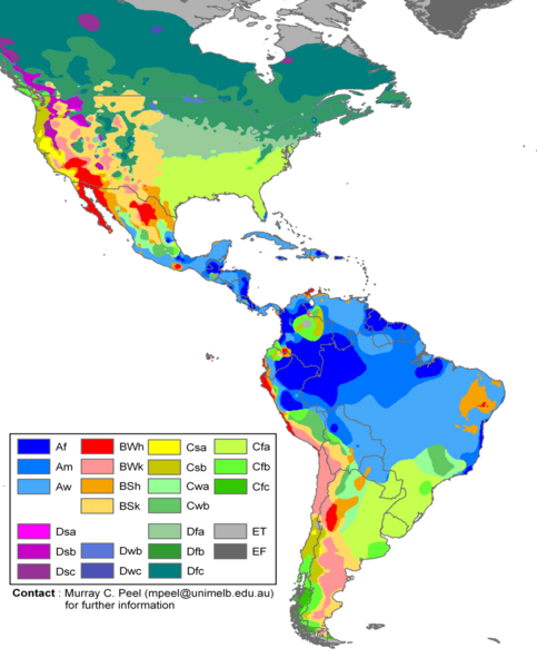
| Beskrivelse |
English: Edited Americas map of the Köppen-Geiger climate classification. The original was a world map JPG file which was converted to a smaller PNG file, without extra modifications, by Jeroen. The PNG file was further modified by WolfmanSF as follows: the map was cropped to reduce it to South America and most of North America; climate zone Dfa was changed to web color 99CC99, and climate zone Dfb was changed to web color 339933 (both shades of green); the color modifications to climate zones of temperate North America were intended to make the colors of tropical climate zones more distinctive, for use in articles on the Great American Interchange. The legend was rearranged, and climate zones Cwc, Dsd, Dwa, Dwd and Dfd were removed from the legend because they do not appear on this map. |
| Dato | |
| Kilde | Hydrology and Earth System Sciences: "Updated world map of the Köppen-Geiger climate classification" (Supplement) |
| Forfatter |
Peel, M. C., Finlayson, B. L., and McMahon, T. A. (University of Melbourne) Citation: Peel, M. C., Finlayson, B. L., and McMahon, T. A.: Updated world map of the Köppen-Geiger climate classification, Hydrol. Earth Syst. Sci., 11, 1633-1644, 2007. |
| Andre versioner |
|

Licensering
Denne fil er udgivet under Creative Commons Navngivelse – Del på samme vilkår 2.5 Generisk-licensen
- Du må frit:
- at dele – at kopiere, distribuere og overføre værket
- at remixe – at tilpasse værket
- Under følgende vilkår:
- kreditering – Du skal give passende kreditering, angive et link til licensen, og oplyse om der er foretaget ændringer. Du må gøre det på enhver fornuftig måde, men ikke på en måde der antyder at licensgiveren godkender dig eller din anvendelse.
- deling på samme vilkår – Hvis du bearbejder, ændrer eller bygger videre på dette værk, skal du distribuere dine bidrag under den samme eller en kompatibel licens som originalen.
Filhistorik
Klik på en dato/tid for at se filen som den så ud på det tidspunkt.
| Dato/tid | Miniaturebillede | Dimensioner | Bruger | Kommentar | |
|---|---|---|---|---|---|
| nuværende | 20. feb. 2018, 21:20 | | 1.096 × 1.360 (520 KB) | Maphobbyist | The Costa Rican Central Valley has a dry winter oceanic climate (Köppen classification: Cwb). |
| 8. feb. 2018, 02:19 |  | 1.096 × 1.360 (433 KB) | WolfmanSF | Reverted to version as of 10:48, 27 December 2008 (UTC) - the northernmost areas aren't of much interest for the purposes of the Great American Interchange article which uses this image | |
| 7. feb. 2018, 23:30 |  | 1.860 × 1.593 (526 KB) | Maphobbyist | Included Alaska, Northern Canada and Greenland which were omitted. | |
| 27. dec. 2008, 12:48 |  | 1.096 × 1.360 (433 KB) | WolfmanSF | {{Information |Description= |Source= |Date= |Author= |Permission= |other_versions= }} | |
| 21. dec. 2008, 23:46 |  | 1.096 × 1.360 (439 KB) | WolfmanSF | rotate legend to make lettering horizontal; remove boxes for unused climate zones | |
| 5. maj 2008, 07:21 |  | 1.096 × 1.360 (428 KB) | WolfmanSF | {{Information |Description=Updated world map of the Köppen-Geiger climate classification. |Source=[http://www.hydrol-earth-syst-sci.net/11/1633/2007/hess-11-1633-2007.html Hydrology and Earth System Sciences: "Updated world map of the Köppen-Geiger clim |
Filanvendelse
Der er ingen sider der bruger denne fil.
Global filanvendelse
Følgende andre wikier anvender denne fil:
- Anvendelser på az.wikipedia.org
- Anvendelser på bg.wikipedia.org
- Anvendelser på en.wikipedia.org
- Anvendelser på es.wikipedia.org
- Anvendelser på fr.wikipedia.org
- Anvendelser på he.wikipedia.org
- Anvendelser på nl.wikipedia.org