
Fil:Flag-map of Papua New Guinea.svg

Size of this PNG preview of this SVG file: 800 × 545 pixels. Andre opløsninger: 320 × 218 pixels | 640 × 436 pixels | 1.024 × 697 pixels | 1.280 × 871 pixels | 2.560 × 1.743 pixels | 1.544 × 1.051 pixels.
Fuld opløsning (SVG fil, basisstørrelse 1.544 × 1.051 pixels, filstørrelse: 606 KB)
|
|
Denne fil er fra Wikimedia Commons. Beskrivelsen af filen fra Commons er gengivet nedenfor. |
Vektorgrafikken blev lavet med Inkscape.
.
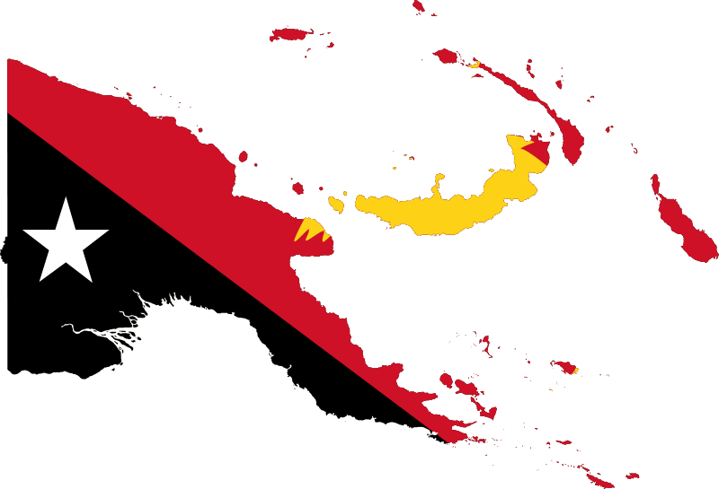
| Beskrivelse | Flag-map of Papua New Guinea |
| Kilde | self-made using Image:Flag of Papua New Guinea.svg and Image:Papua New Guinea location map.svg |
| Forfatter | Darwinek |
Jeg, dette værks ophavsretsindehaver, udgiver hermed værket under den følgende licens:
Denne fil er udgivet under Creative Commons Kreditering-Del på samme vilkår 3.0 Ikke-porteret-licensen.
- Du må frit:
- at dele – at kopiere, distribuere og overføre værket
- at remixe – at tilpasse værket
- Under følgende vilkår:
- kreditering – Du skal give passende kreditering, angive et link til licensen, og oplyse om der er foretaget ændringer. Du må gøre det på enhver fornuftig måde, men ikke på en måde der antyder at licensgiveren godkender dig eller din anvendelse.
- deling på samme vilkår – Hvis du bearbejder, ændrer eller bygger videre på dette værk, skal du distribuere dine bidrag under den samme eller en kompatibel licens som originalen.

|
Tilladelse er givet til at kopiere, distribuere og/eller ændre dette dokument under betingelserne i GNU Free Documentation License', Version 1.2 eller enhver senere version udgivet af Free Software Foundation; uden et invariant afsnit, ingen forsidetekster, og ingen bagsidetekst. En kopi af licensen er inkluderet i afsnittet GNU Free Documentation License. |
Du kan vælge den licens du foretrækker.
Filhistorik
Klik på en dato/tid for at se filen som den så ud på det tidspunkt.
| Dato/tid | Miniaturebillede | Dimensioner | Bruger | Kommentar | |
|---|---|---|---|---|---|
| nuværende | 9. dec. 2010, 08:27 | | 1.544 × 1.051 (606 KB) | Fry1989 | reduce |
| 6. sep. 2008, 10:32 |  | 1.546 × 1.053 (777 KB) | Darwinek | {{GFDL}} <!--{{ImageUpload|basic}}--> |
Filanvendelse
Der er ingen sider der bruger denne fil.
Global filanvendelse
Følgende andre wikier anvender denne fil:
- Anvendelser på ar.wikinews.org
- Anvendelser på en.wikipedia.org
- Seeadler Harbor
- Vulcan (volcano)
- Salamaua
- Aiyura
- Adelbert Range
- Atea Cave
- Tagula Island
- Template:PapuaNewGuinea-geo-stub
- Chambri Lakes
- Lake Murray (Papua New Guinea)
- Milne Bay
- Western Highlands Province
- Konedobu
- Kieta
- Madau
- Finschhafen District
- Namatanai
- Boluminski Highway
- Kiriwina
- Markham Valley
- Bismarck Range
- Agaiambo
- Langila
- Panguna
- Alas Islands
- Cape Gloucester (Papua New Guinea)
- Empress Augusta Bay
- Garbuna Group
- Mendi
- Popondetta
- Cape Torokina
- Ambitle
- Lyra Reef
- Waigani
- Green Islands (Papua New Guinea)
- Nissan Island
- St Matthias Islands
- Kiunga, Papua New Guinea
- Dart Reefs
- Ward Hunt Strait
- Cape St. George
- Marshall Bennett Islands
- Blup Blup
- Ghost Mountain
- Kikori
- Umboi Island
- Astrolabe Bay
- Ritter Island
- Saint George's Channel (Papua New Guinea)
Vis flere globale anvendelser af denne fil.