
Fil:Great Lakes bathymetry map.png
Fuld opløsning (1.024 × 731 billedpunkter, filstørrelse: 1,34 MB, MIME-type: image/png)
|
|
Denne fil er fra Wikimedia Commons. Beskrivelsen af filen fra Commons er gengivet nedenfor. |
Beskrivelse
| Beskrivelse |
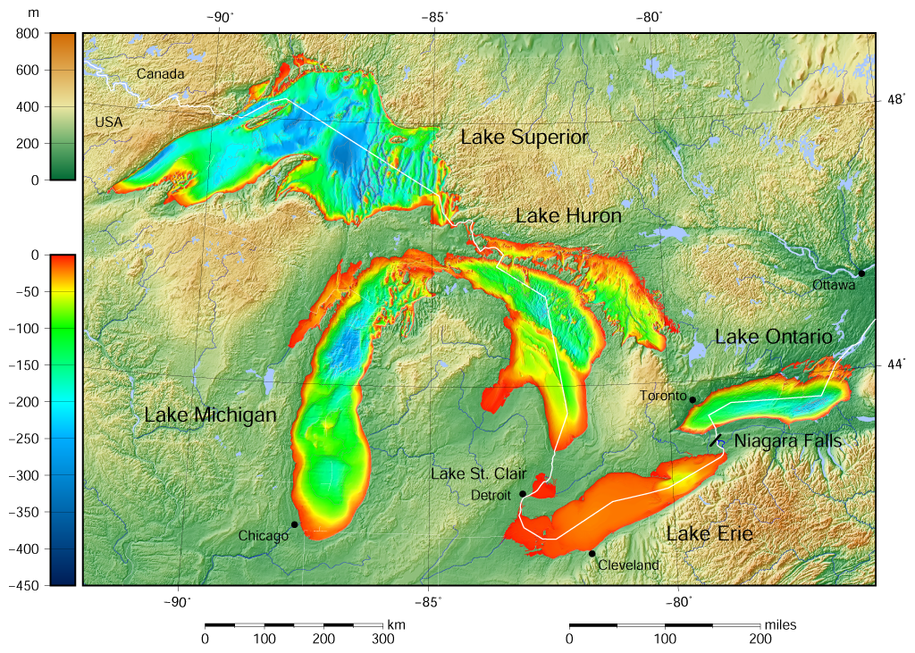
English: Great Lakes bathymetry and surrounding area shaded relief map. Lakes are contoured with interval 100 m. Lake Superior is incomplete. |
| Dato | |
| Kilde |
Own work using: the following Public Domain datasets (grids):
The color palette of the depth scale was made to be more or less similar to the color palettes used on the NGDC Great Lakes maps. |
| Forfatter | Darekk2 using the Great Lakes Bathymetry and GLOBE tiles |
| Andre versioner |
|

Licensering
Attribution (in addition to the author of this map):
The NGDC in it's copyright notice says:
As required by 17 U.S.C. 403, third parties producing copyrighted works consisting predominantly of the material produced by U.S. government agencies must provide notice with such work(s) identifying the U.S. Government material incorporated and stating that such material is not subject to copyright protection within the United States. (...)
(for credits see the Source section).
and Great Lakes Bathymetry and GLOBE
(see above and the Source section)
- Du må frit:
- at dele – at kopiere, distribuere og overføre værket
- at remixe – at tilpasse værket
- Under følgende vilkår:
- kreditering – Du skal give passende kreditering, angive et link til licensen, og oplyse om der er foretaget ændringer. Du må gøre det på enhver fornuftig måde, men ikke på en måde der antyder at licensgiveren godkender dig eller din anvendelse.
- deling på samme vilkår – Hvis du bearbejder, ændrer eller bygger videre på dette værk, skal du distribuere dine bidrag under den samme eller en kompatibel licens som originalen.
Filhistorik
Klik på en dato/tid for at se filen som den så ud på det tidspunkt.
| Dato/tid | Miniaturebillede | Dimensioner | Bruger | Kommentar | |
|---|---|---|---|---|---|
| nuværende | 9. maj 2015, 17:46 | | 1.024 × 731 (1,34 MB) | Darekk2 | more accurate shorelines, the lakes tiles better assembled, added Canada, USA and Lake St. Clair labels, moved Detroit label, Michigan Lake - retouched western part of Green Bay |
| 25. mar. 2015, 12:03 |  | 1.024 × 731 (1,34 MB) | Darekk2 | changed illumination for shaded relief | |
| 25. mar. 2015, 03:29 |  | 1.024 × 731 (1,33 MB) | Darekk2 | changed palette a little | |
| 24. mar. 2015, 22:21 |  | 1.024 × 731 (1,61 MB) | Darekk2 | User created page with UploadWizard |
Filanvendelse
Der er ingen sider der bruger denne fil.
Global filanvendelse
Følgende andre wikier anvender denne fil:
- Anvendelser på ar.wikipedia.org
- Anvendelser på en.wikipedia.org
- Anvendelser på fi.wikipedia.org
- Anvendelser på ja.wikipedia.org
- Anvendelser på nl.wikipedia.org
- Anvendelser på sr.wikipedia.org
- Anvendelser på tt.wikipedia.org
- Anvendelser på uk.wikipedia.org
- Anvendelser på vep.wikipedia.org
- Anvendelser på www.wikidata.org
- Anvendelser på zh-yue.wikipedia.org