
Fil:Hudson bay explorer.png
Hudson_bay_explorer.png (550 × 442 billedpunkter, filstørrelse: 449 KB, MIME-type: image/png)
|
|
Denne fil er fra Wikimedia Commons. Beskrivelsen af filen fra Commons er gengivet nedenfor. |
| Beskrivelse |
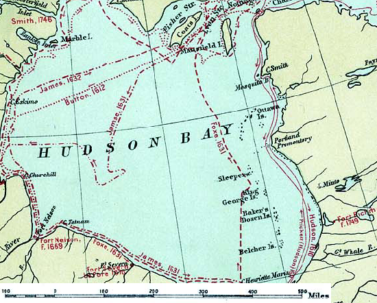
English: Map of the routes of the main European explorers in Hudson Bay, Canada. |
|||||
| Dato | ||||||
| Kilde | Excerpted from 1st Edition, 1906, Atlas of Canada - Routes of Explorers,1497 to 1905. | |||||
| Forfatter | Department of the Interior, Ottawa | |||||
| Tilladelse (Genbrug af denne fil) |
Crown copyright expired.
|

Oprindelig oplægningslog
- 2007-01-26 22:28 CyclePat 550×442×8 (459278 bytes) ==Description== This map shows the routes followed by the principal explorers of what is now Canada, from 1497 up to 1905. The map also shows the location of forts with the date of their establishment. It was created using [[:image:Canada, Routes of Explo
Filhistorik
Klik på en dato/tid for at se filen som den så ud på det tidspunkt.
| Dato/tid | Miniaturebillede | Dimensioner | Bruger | Kommentar | |
|---|---|---|---|---|---|
| nuværende | 10. jul. 2008, 13:41 | | 550 × 442 (449 KB) | Urdangaray | {{Information |Description={{en|thumb|400px|right|Canada, Routes of Explorers,1497 to 1905 This map shows the routes followed by the principal explorers of what is now Canada, from 1497 up to 190 |
Filanvendelse
Der er ingen sider der bruger denne fil.
Global filanvendelse
Følgende andre wikier anvender denne fil:
- Anvendelser på arz.wikipedia.org
- Anvendelser på ast.wikipedia.org
- Anvendelser på az.wikipedia.org
- Anvendelser på bg.wikipedia.org
- Anvendelser på ca.wikipedia.org
- Anvendelser på cv.wikipedia.org
- Anvendelser på de.wikipedia.org
- Anvendelser på en.wikipedia.org
- Anvendelser på es.wikipedia.org
- Anvendelser på hi.wikipedia.org
- Anvendelser på nn.wikipedia.org
- Anvendelser på ru.wikipedia.org
- Anvendelser på zh.wikipedia.org