
Fil:Scotland 1974 Administrative Map.png

Størrelse af denne forhåndsvisning: 345 × 600 pixels. Andre opløsninger: 138 × 240 pixels | 276 × 480 pixels | 442 × 768 pixels | 589 × 1.024 pixels | 2.000 × 3.476 pixels.
Fuld opløsning (2.000 × 3.476 billedpunkter, filstørrelse: 1,42 MB, MIME-type: image/png)
|
|
Denne fil er fra Wikimedia Commons. Beskrivelsen af filen fra Commons er gengivet nedenfor. |
Beskrivelse
| Beskrivelse |
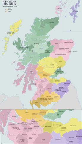
English: Administrative map of Scotland in 1974 showing the reforms of the Local Government Act (Scotland) 1973 |
| Dato | |
| Kilde | Eget arbejde |
| Forfatter | XrysD |
Licensering
Jeg, dette værks ophavsretsindehaver, publicerer hermed værket under den følgende licens:
Denne fil er udgivet under Creative Commons Kreditering-Del på samme vilkår 3.0 Ikke-porteret-licensen.
- Du må frit:
- at dele – at kopiere, distribuere og overføre værket
- at remixe – at tilpasse værket
- Under følgende vilkår:
- kreditering – Du skal give passende kreditering, angive et link til licensen, og oplyse om der er foretaget ændringer. Du må gøre det på enhver fornuftig måde, men ikke på en måde der antyder at licensgiveren godkender dig eller din anvendelse.
- deling på samme vilkår – Hvis du bearbejder, ændrer eller bygger videre på dette værk, skal du distribuere dine bidrag under den samme eller en kompatibel licens som originalen.
Filhistorik
Klik på en dato/tid for at se filen som den så ud på det tidspunkt.
| Dato/tid | Miniaturebillede | Dimensioner | Bruger | Kommentar | |
|---|---|---|---|---|---|
| nuværende | 19. jul. 2020, 10:49 | | 2.000 × 3.476 (1,42 MB) | XrysD | Fixed typos: Tweedale->Tweeddale, Kirkintuloch->Kirkintilloch, Eastward->Eastwood, Cunningham->Cunninghame |
| 25. nov. 2012, 12:04 |  | 2.000 × 3.475 (1,55 MB) | XrysD | Corrected date. Added categories | |
| 24. nov. 2012, 12:03 |  | 2.000 × 3.475 (1,55 MB) | XrysD | User created page with UploadWizard |
Filanvendelse
Der er ingen sider der bruger denne fil.
Global filanvendelse
Følgende andre wikier anvender denne fil:
- Anvendelser på de.wikipedia.org
- Anvendelser på en.wikipedia.org
- Angus, Scotland
- Clackmannanshire
- Fife
- East Lothian
- Dumfries and Galloway
- Midlothian
- Highland (council area)
- Scottish Borders
- Moray
- Argyll and Bute
- Inverclyde
- Lothian
- West Lothian
- Politics of Edinburgh
- Perth and Kinross
- Falkirk (council area)
- Lochaber
- Berwickshire
- Sutherland
- Ross and Cromarty
- Tayside
- Grampian
- Caithness
- Roxburghshire
- Strathclyde
- Stirling (council area)
- Cunninghame
- County of Nairn
- Tweeddale
- Ettrick and Lauderdale
- Annandale and Eskdale
- Nithsdale
- Stewartry
- North East Fife (district)
- Banff and Buchan
- Gordon (district)
- Kincardine and Deeside
- Badenoch and Strathspey
- Skye and Lochalsh
- Bearsden and Milngavie
- Cumbernauld and Kilsyth (district)
- Cumnock and Doon Valley
- Clydesdale (district)
- Eastwood, Strathclyde
- Kilmarnock and Loudoun (district)
- Kyle and Carrick
- Strathkelvin
- Local government areas of Scotland (1975–1996)
- Comhairle nan Eilean Siar
Vis flere globale anvendelser af denne fil.