
Fil:South East England districts 2011 map.svg

Size of this PNG preview of this SVG file: 749 × 600 pixels. Andre opløsninger: 300 × 240 pixels | 600 × 480 pixels | 959 × 768 pixels | 1.279 × 1.024 pixels | 2.558 × 2.048 pixels | 1.425 × 1.141 pixels.
Fuld opløsning (SVG fil, basisstørrelse 1.425 × 1.141 pixels, filstørrelse: 2,18 MB)
|
|
Denne fil er fra Wikimedia Commons. Beskrivelsen af filen fra Commons er gengivet nedenfor. |
Beskrivelse
| Beskrivelse |
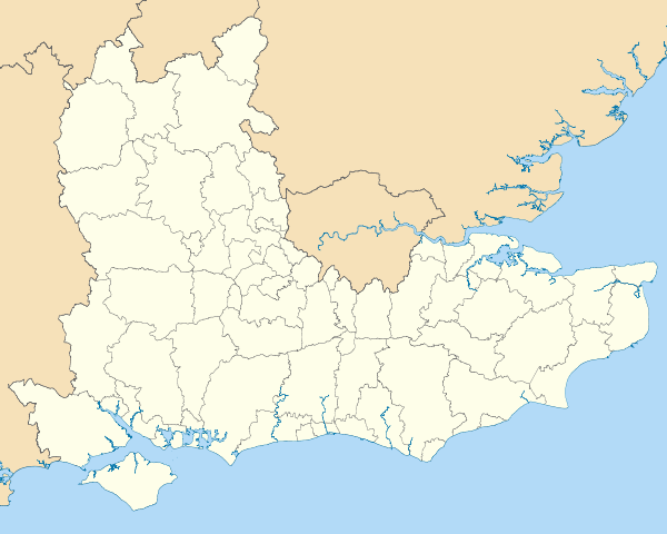
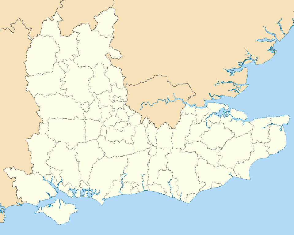
Map of the South East England region showing the administrative districts. Equirectangular map projection on WGS 84 datum, with N/S stretched 160% Geographic limits:
|
| Dato | |
| Kilde |
|
| Forfatter | Nilfanion, created using Ordnance Survey data |
| Andre versioner |
Derivative works of this file: |
Licensering
Jeg, dette værks ophavsretsindehaver, udgiver hermed værket under den følgende licens:
Denne fil er udgivet under Creative Commons Kreditering-Del på samme vilkår 3.0 Ikke-porteret-licensen.
- Du må frit:
- at dele – at kopiere, distribuere og overføre værket
- at remixe – at tilpasse værket
- Under følgende vilkår:
- kreditering – Du skal give passende kreditering, angive et link til licensen, og oplyse om der er foretaget ændringer. Du må gøre det på enhver fornuftig måde, men ikke på en måde der antyder at licensgiveren godkender dig eller din anvendelse.
- deling på samme vilkår – Hvis du bearbejder, ændrer eller bygger videre på dette værk, skal du distribuere dine bidrag under den samme eller en kompatibel licens som originalen.

|
Tilladelse er givet til at kopiere, distribuere og/eller ændre dette dokument under betingelserne i GNU Free Documentation License', Version 1.2 eller enhver senere version udgivet af Free Software Foundation; uden et invariant afsnit, ingen forsidetekster, og ingen bagsidetekst. En kopi af licensen er inkluderet i afsnittet GNU Free Documentation License. |
Du kan vælge den licens du foretrækker.
Filhistorik
Klik på en dato/tid for at se filen som den så ud på det tidspunkt.
| Dato/tid | Miniaturebillede | Dimensioner | Bruger | Kommentar | |
|---|---|---|---|---|---|
| nuværende | 1. maj 2011, 21:04 | | 1.425 × 1.141 (2,18 MB) | Nilfanion | == Summary == {{Information |Description=Map of the South East England region showing the administrative districts. Equirectangular map projection on WGS 84 datum, with N/S stretched 160% Geographic limits: *West: 2.0W *East: 1. |
Filanvendelse
Der er ingen sider der bruger denne fil.
Global filanvendelse
Følgende andre wikier anvender denne fil:
- Anvendelser på ar.wikipedia.org
- Anvendelser på bs.wikipedia.org
- Anvendelser på ceb.wikipedia.org
- Anvendelser på en.wikipedia.org
- Hastings
- Isle of Wight
- Oxford
- Portsmouth
- Reading, Berkshire
- South East England
- Oxfordshire
- East Sussex
- Brighton and Hove
- Bracknell Forest
- Borough of Runnymede
- Crawley
- Reigate and Banstead
- Mid Sussex District
- Medway
- Hart District
- West Berkshire
- Borough of Waverley
- Royal Borough of Windsor and Maidenhead
- Adur District
- Arun District
- Gosport
- Sevenoaks
- Borough of Dartford
- Basingstoke and Deane
- Worthing
- City of Milton Keynes
- Cherwell (district)
- Wealden District
- Vale of White Horse
- Tonbridge and Malling
- East Hampshire
- Rushmoor
- Test Valley
- Gravesham
- Borough of Swale
- Folkestone and Hythe District
- South Oxfordshire
- West Oxfordshire
- Borough of Spelthorne
- Surrey Heath
- Borough of Elmbridge
- Mole Valley
- Epsom and Ewell
- Tandridge District
- Rother District
- Lewes District
Vis flere globale anvendelser af denne fil.