
Fil:Sulawesi location map plain.svg

Fuld opløsning (SVG fil, basisstørrelse 744 × 938 pixels, filstørrelse: 1.012 KB)
|
|
Denne fil er fra Wikimedia Commons. Beskrivelsen af filen fra Commons er gengivet nedenfor. |
Beskrivelse
| Beskrivelse |
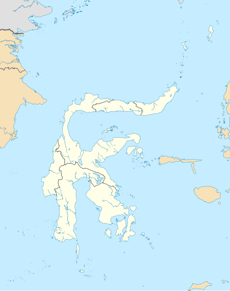
Bahasa Indonesia: Peta Pulau Sulawesi dengan batas administratif serta pulau-pulau di sekitarnya yang termasuk dalam provinsi yang ada di Sulawesi. Cakupan peta dibuat lebih besar untuk menampilkan Liukang Tangaya dan Masalima, Sulawesi Selatan, Bala Balakang, Sulawesi Barat, serta Miangas, Sulawesi Utara. Saya tidak menyertakan batas perairan karena tidak ada sumber resmi yang saya dapat temukan.
English: Plain map of the island of Sulawesi with administrative borders and surrounding islands belonged to the provinces in the island, including Liukang Tangaya and Masalima, South Sulawesi, Bala Balakang, West Sulawesi, and Miangas, North Sulawesi. I did not add maritime borders because I did not find any official sources in regards to it. |
|||||||||
| Creation | Vektorgrafikken blev lavet med Inkscape.
. Vektorgrafikken blev lavet med QGIS. |
|||||||||
| Dato | ||||||||||
| Kilde |
Bahasa Indonesia: Karya sendiri;
English: Own work;
|
|||||||||
| Skaber | ||||||||||
| Tilladelse (Genbrug af denne fil) |
Attribution like in #Licensering below is required for including this image outside of Wikimedia projects. | |||||||||
| Geotemporal data | ||||||||||
| Spatial reference system | Equirectangular | |||||||||
| Heading |
 |
|||||||||
| Bounding box |
|
|||||||||
| Andre versioner |
|
|||||||||

Licensering
- Du må frit:
- at dele – at kopiere, distribuere og overføre værket
- at remixe – at tilpasse værket
- Under følgende vilkår:
- kreditering – Du skal give passende kreditering, angive et link til licensen, og oplyse om der er foretaget ændringer. Du må gøre det på enhver fornuftig måde, men ikke på en måde der antyder at licensgiveren godkender dig eller din anvendelse.
- deling på samme vilkår – Hvis du bearbejder, ændrer eller bygger videre på dette værk, skal du distribuere dine bidrag under den samme eller en kompatibel licens som originalen.
Filhistorik
Klik på en dato/tid for at se filen som den så ud på det tidspunkt.
| Dato/tid | Miniaturebillede | Dimensioner | Bruger | Kommentar | |
|---|---|---|---|---|---|
| nuværende | 27. okt. 2020, 14:50 | | 744 × 938 (1.012 KB) | RXerself | Sonit |
| 24. okt. 2020, 07:43 |  | 744 × 938 (1.012 KB) | RXerself | Bala Balakang | |
| 24. okt. 2020, 01:10 |  | 744 × 938 (1.012 KB) | RXerself | {{Map |Description={{id|1=Peta Pulau Sulawesi dengan batas administratif serta pulau-pulau di sekitarnya yang termasuk dalam provinsi yang ada di Sulawesi. Cakupan peta dibuat lebih besar untuk menampilkan Liukang Tangaya dan Masalima, Sulawesi Selatan serta Miangas, Sulawesi Utara.}} {{en|1=Plain map of the island of Sulawesi with administrative borders and surrounding islands belonged to the provinces in the island, including Liukang Tangaya and Masalima, S... |
Filanvendelse
Der er ingen sider der bruger denne fil.
Global filanvendelse
Følgende andre wikier anvender denne fil:
- Anvendelser på en.wikipedia.org
- Sangir Island
- Makassar
- Poso
- Manado
- Buton
- Palu
- Banggai Regency
- Donggala Regency
- Luwuk
- Peleng
- Minahasa Peninsula
- East Peninsula, Sulawesi
- Southeast Peninsula, Sulawesi
- South Peninsula, Sulawesi
- Gulf of Tomini
- Kendari
- Mamuju (city)
- Parepare
- List of national parks of Indonesia
- Lagaligo Stadium
- Andi Mattalatta Stadium
- Sam Ratulangi International Airport
- Wakatobi Regency
- Muna Island
- User:Indon/sandbox
- Gorontalo (city)
- Maesa Stadium
- Ambang Stadium
- Adam Air Flight 574
- Bitung
- Jalaluddin Airport
- Haluoleo Airport
- Mutiara SIS Al-Jufrie Airport
- Sultan Hasanuddin International Airport
- Palopo
- Tomohon
- Selayar Islands Regency
- Selayar Island
- Baubau
- Kabaena
- Karakelong
- Wawonii Island
- Bogani Nani Wartabone National Park
- Rawa Aopa Watumohai National Park
- Majene
- Module:Location map/data/Indonesia Sulawesi/doc
- Watansoppeng
- Buol (town)
- Buol Regency
- Kasiguncu Airport
Vis flere globale anvendelser af denne fil.