
Fil:Tectonics Sumatra quake.gif

Størrelse af denne forhåndsvisning: 463 × 599 pixels. Andre opløsninger: 185 × 240 pixels | 612 × 792 pixels.
Fuld opløsning (612 × 792 billedpunkter, filstørrelse: 63 KB, MIME-type: image/gif, 0,2 s)
|
|
Denne fil er fra Wikimedia Commons. Beskrivelsen af filen fra Commons er gengivet nedenfor. |
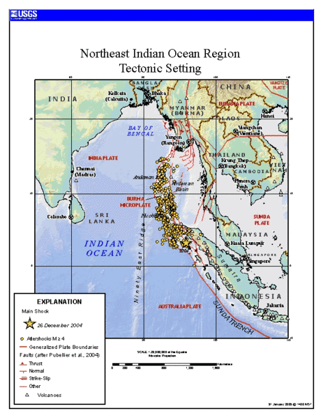
Source
https://earthquake.usgs.gov/eqinthenews/2004/usslav/ Tectonic setting of Sumatra earthquake - updated map (first maps posted by USGS was showing unrealistic plate boundaries)
This image is in the public domain in the United States because it only contains materials that originally came from the United States Geological Survey, an agency of the United States Department of the Interior. For more information, see the official USGS copyright policy.
|
Filhistorik
Klik på en dato/tid for at se filen som den så ud på det tidspunkt.
| Dato/tid | Miniaturebillede | Dimensioner | Bruger | Kommentar | |
|---|---|---|---|---|---|
| nuværende | 24. jan. 2006, 14:24 | | 612 × 792 (63 KB) | RobinL~commonswiki | ==Source== http://earthquake.usgs.gov/eqinthenews/2004/usslav/ Tectonic setting of Sumatra earthquake - updated map (first maps posted by USGS was showing unrealistic plate boundaries) {{PD-USGov-USGS}} |
Filanvendelse
Der er ingen sider der bruger denne fil.
Global filanvendelse
Følgende andre wikier anvender denne fil:
- Anvendelser på ar.wikipedia.org
- Anvendelser på ca.wikipedia.org
- Anvendelser på el.wikipedia.org
- Anvendelser på en.wikipedia.org
- Anvendelser på es.wikipedia.org
- Anvendelser på fa.wikipedia.org
- Anvendelser på fr.wikipedia.org
- Anvendelser på hi.wikipedia.org
- Anvendelser på id.wikipedia.org
- Anvendelser på ja.wikipedia.org
- Anvendelser på ko.wikipedia.org
- Anvendelser på my.wikipedia.org
- Anvendelser på pt.wikipedia.org
- Anvendelser på ru.wikipedia.org
- Anvendelser på sl.wikipedia.org
- Anvendelser på sr.wikipedia.org
- Anvendelser på th.wikipedia.org
- Anvendelser på tr.wikipedia.org
- Anvendelser på uk.wikipedia.org
- Anvendelser på zh.wikipedia.org