
Fil:Wirral peninsula satellite.png
Der findes ingen højere opløsning af billedet
Wirral_peninsula_satellite.png (400 × 400 billedpunkter, filstørrelse: 299 KB, MIME-type: image/png)
|
|
Denne fil er fra Wikimedia Commons. Beskrivelsen af filen fra Commons er gengivet nedenfor. |
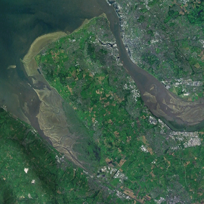
| Beskrivelse | A satellite photograph of the Wirral Peninsula (centre), showing the River Mersey and its estuary to the east, Liverpool Bay to the north and River Dee in the west across from the coast of Flintshire in Wales. |
| Dato | |
| Kilde | NASA World Wind - Landsat 7 |
| Forfatter | Smurrayinchester |
| This image is in the public domain because it is a screenshot from NASA’s globe software World Wind using a public domain layer, such as Blue Marble, MODIS, Landsat, SRTM, USGS or GLOBE.
|
 |
| Kameraposition | | Dette og andre billeder på deres position på: OpenStreetMap |
|---|

Filhistorik
Klik på en dato/tid for at se filen som den så ud på det tidspunkt.
| Dato/tid | Miniaturebillede | Dimensioner | Bruger | Kommentar | |
|---|---|---|---|---|---|
| nuværende | 29. aug. 2022, 22:33 | | 400 × 400 (299 KB) | DankJae | File:Liverpool Bay.png cropped 69 % horizontally, 58 % vertically using CropTool with precise mode. |
Filanvendelse
Der er ingen sider der bruger denne fil.
Global filanvendelse
Følgende andre wikier anvender denne fil:
- Anvendelser på cy.wikipedia.org
- Anvendelser på en.wikipedia.org