
Fil:Spitalfields rookery.jpg
Der findes ingen højere opløsning af billedet
Spitalfields_rookery.jpg (800 × 417 billedpunkter, filstørrelse: 459 KB, MIME-type: image/jpeg)
|
|
Denne fil er fra Wikimedia Commons. Beskrivelsen af filen fra Commons er gengivet nedenfor. |
| Beskrivelse |
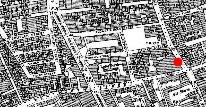
English: 1894 ordnance survey map of Whitechapel showing the area around en:Spitalfields where many common lodging-houses were situated in the late Victorian era. Red circle indicates the location at the junction of Osborn Street and en:Brick Lane near where en:Emma Elizabeth Smith (the first en:Whitechapel murders victim) was attacked. The building to the immediate west of the red circle is a chocolate factory. |
||||||
| Dato | 1894, amended 2009 | ||||||
| Kilde | Original map downloaded from http://www.casebook.org/official_documents/map/images/ord_map_full.jpg | ||||||
| Forfatter | Ordnance Survey, modified by uploader | ||||||
| Tilladelse (Genbrug af denne fil) |
|
||||||
| Andre versioner | Cropped from File:Whitechapel murders.jpg |

Filhistorik
Klik på en dato/tid for at se filen som den så ud på det tidspunkt.
| Dato/tid | Miniaturebillede | Dimensioner | Bruger | Kommentar | |
|---|---|---|---|---|---|
| nuværende | 4. dec. 2009, 12:41 | | 800 × 417 (459 KB) | DrKay | {{Information |Description={{en|1=1894 ordnance survey map of Whitechapel showing the area around en:Spitalfields where many common lodging-houses were situated in the late Victorian era. Red circle indicates the location at the junction of Osborn St |
Filanvendelse
Den følgende side bruger denne fil:
Global filanvendelse
Følgende andre wikier anvender denne fil:
- Anvendelser på en.wikipedia.org
- Anvendelser på es.wikipedia.org
- Anvendelser på fr.wikipedia.org
- Anvendelser på ja.wikipedia.org
- Anvendelser på ko.wikipedia.org
- Anvendelser på no.wikipedia.org
- Anvendelser på ru.wikipedia.org
- Anvendelser på zh.wikipedia.org