
Fil:Atbara river map.jpg

Størrelse af denne forhåndsvisning: 800 × 466 pixels. Andre opløsninger: 320 × 186 pixels | 640 × 372 pixels | 1.141 × 664 pixels.
Fuld opløsning (1.141 × 664 billedpunkter, filstørrelse: 198 KB, MIME-type: image/jpeg)
|
|
Denne fil er fra Wikimedia Commons. Beskrivelsen af filen fra Commons er gengivet nedenfor. |
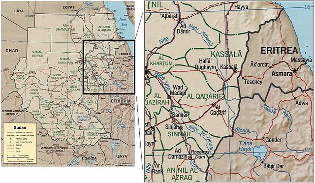
The Atbara river, in Sudan and Eritrea. Source: image:Sudan political map 2000.jpg
CIA map of Sudan from 2000
http://hdl.loc.gov/loc.gmd/g8310.ct001564
| This image is a work of a Central Intelligence Agency employee, taken or made as part of that person's official duties. As a Work of the United States Government, this image or media is in the public domain in the United States.
|

|
Filhistorik
Klik på en dato/tid for at se filen som den så ud på det tidspunkt.
| Dato/tid | Miniaturebillede | Dimensioner | Bruger | Kommentar | |
|---|---|---|---|---|---|
| nuværende | 22. sep. 2006, 14:26 | | 1.141 × 664 (198 KB) | Laur2ro | The Atbara river, in Sudan and Eritrea. Source: image:Sudan political map 2000.jpg CIA map of Sudan from 2000 http://hdl.loc.gov/loc.gmd/g8310.ct001564 {{PD-USGov-CIA}} Category:Maps of Sudan |
Filanvendelse
Den følgende side bruger denne fil:
Global filanvendelse
Følgende andre wikier anvender denne fil:
- Anvendelser på ar.wikipedia.org
- Anvendelser på az.wikipedia.org
- Anvendelser på be.wikipedia.org
- Anvendelser på ca.wikipedia.org
- Anvendelser på ceb.wikipedia.org
- Anvendelser på cs.wikipedia.org
- Anvendelser på de.wikipedia.org
- Anvendelser på es.wikipedia.org
- Anvendelser på et.wikipedia.org
- Anvendelser på eu.wikipedia.org
- Anvendelser på fi.wikipedia.org
- Anvendelser på fr.wikipedia.org
- Anvendelser på he.wikipedia.org
- Anvendelser på hu.wikipedia.org
- Anvendelser på it.wikipedia.org
- Anvendelser på ml.wikipedia.org
- Anvendelser på nl.wikipedia.org
- Anvendelser på pl.wikipedia.org
- Anvendelser på pt.wikipedia.org
- Anvendelser på ro.wikipedia.org
- Anvendelser på ru.wikipedia.org
- Anvendelser på sh.wikipedia.org
- Anvendelser på uk.wikipedia.org
- Anvendelser på uz.wikipedia.org
- Anvendelser på www.wikidata.org
- Anvendelser på xmf.wikipedia.org
- Anvendelser på zh.wikipedia.org