Fil:Carte TGV.svg

Page contents not supported in other languages.
Fra Wikipedia, den frie encyklopædi

Fuld opløsning(SVG fil, basisstørrelse 1.000 × 1.056 pixels, filstørrelse: 992 KB)


Denne fil er fra Wikimedia Commons

Beskrivelse

This file may be updated to reflect new information.
If you wish to use a specific version of the file without new updates being mirrored, please upload the required version as a separate file.
Beskrivelse
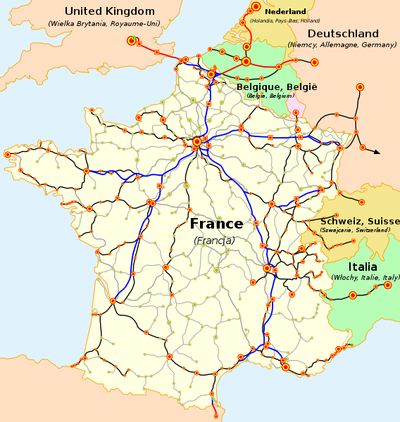
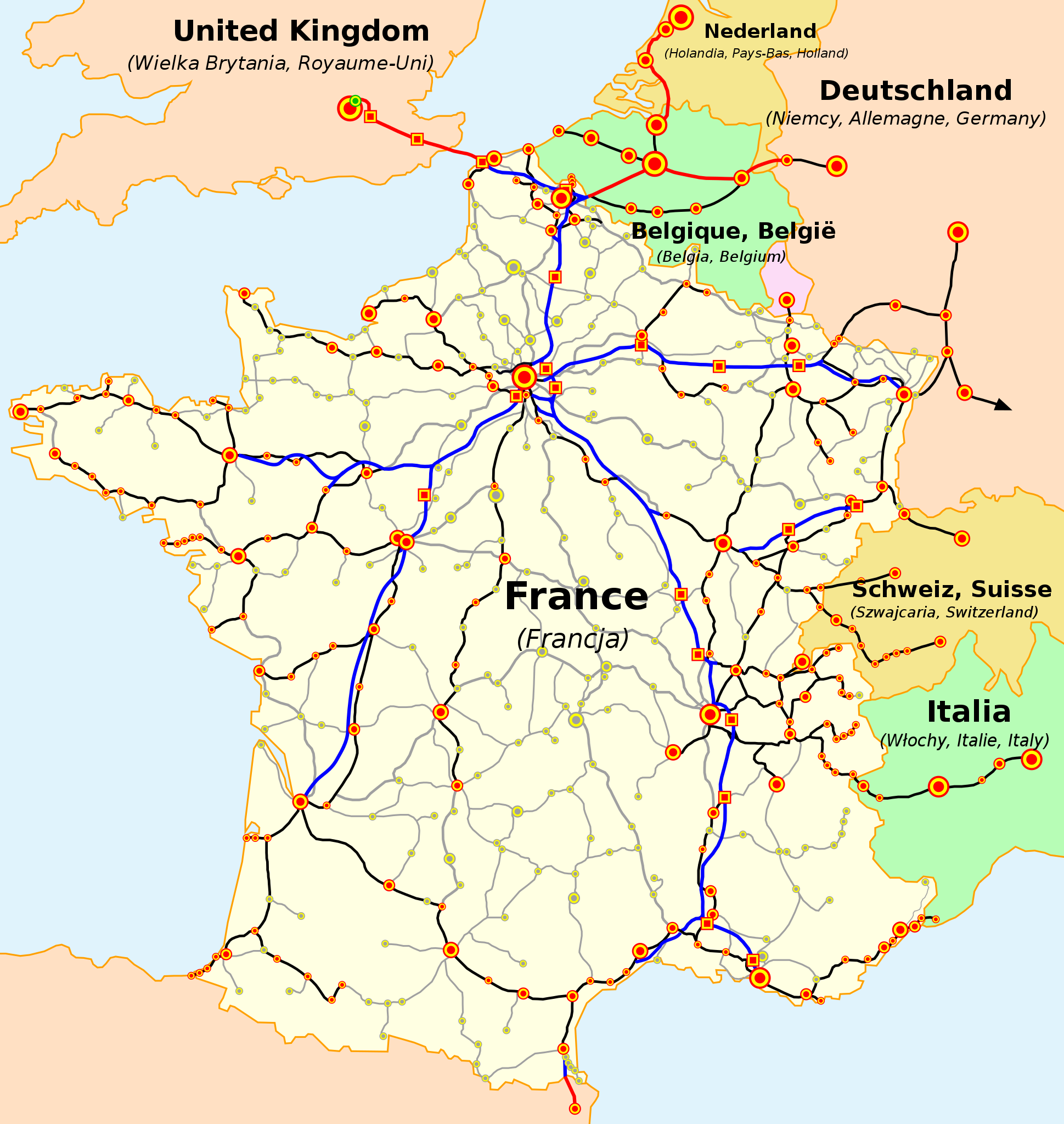
Français : La carte du réseau voyageurs de la SNCF, les TGV internationaux inclus
English: The map of French railways (SNCF) passengers service, including international TGV high-speed trains
Deutsch: Karte der französischen Eisenbahn (SNCF) mit TGV Hochgeschwindigkeitsnetz
Español: Mapa de las líneas de ferrocarril de la SNCF, incluidas las líneas de TGV (alta velocidad)
Čeština: Mapa tratí francouzských železnic (SNCF) s přepravou cestujících včetně mezinárodních spojení TGV
Nederlands: Kaart van de Franse Spoorwegen (SNCF), inclusief internationale TGV hogesnelheidstreinen
Polski: Mapa sieci połączeń pasażerskich kolei francuskich (SNCF), uwzlędniająca międzynarodowe połączenia pociągami TGV
Русский: Карта пассажирского железнодорожного транспорта Франции, включая международные скоростные поезда TGV
Slovenčina: Mapa tratí francúzskych železníc (SNCF) s prepravou cestujúcich a medzinárodných spojení TGV
Català: La xarxa TGV: -en blau i en vermell: línies d'alta velocitat, -en negre: línies clàssiques per on circulen trens TGV, -puntejat: línies en projecte (TGV Est)

(cs) Vysvětlivky

  • Železniční tratě:
    • modrá — vysokorychlostní tratě (LGV) ve Francii
    • červená — vysokorychlostní tratě mimo Francii
    • černá — běžné tratě s provozem TGV
    • čárkovaná červená/modrá — vysokorychlostní tratě ve stavbě
    • čárkovaná černá — běžné tratě s plánovaným provozem TGV v blízké budoucnosti
    • šedá — ostatní tratě s dopravou cestujících
  • Železniční stanice a města:
    • červená:
      • kruhy — stanice obsluhovaná TGV
      • čtverce — stanice obsluhovaná výhradně TGV (na LGV)
    • zelená:
      • kruhy — stanice s plánovanou obsluhou TGV v blízké budoucnosti
      • čtverce — stanice na LGV ve stavbě
    • šedá — stanice s dopravou cestujících běžnými vlaky

Velikost značek označuje přibližně velikost měst

(de) Legende

  • Eisenbahnlinien:
    • blau - Hochgeschwindigkeitsstrecken in Frankreich,
    • rot - Hochgeschwindigkeitsstrecken außerhalb Frankreichs,
    • schwarz - Klassische Bahnlinien mit TGV-Nutzung,
    • rot und blau gepunktet - Hochgeschwindigkeitsstrecken in Bau,
    • schwarz gepunktet - Klassische Bahnlinien mit TGV-Nutzung in Planung,
    • grau - andere klassische Bahnlinien im Passagierverkehr
  • Bahnhöfe und Städte:
    • rot:
      • Punkte - mit TGV Anbindung,
      • Quadrate - ausschließlich TGV Anbindung
    • grün:
      • Punkte - mit zukünftiger TGV Anbindung,
      • Quadrate - mit zukünftiger, ausschließlicher TGV Anbindung,
    • Graue Punkte - andere Personenbahnhöfe,
Die Größe der Punkte spiegelt die Größe der Städte wieder.

(es) Leyenda

  • Lineas Ferroviarias:
    • Azul- Lineas de alta velocidad (LGV) en Francia.
    • Rojo- Lineas de alta velocidad exteriores a Francia.
    • Negro- Lineas ferroviarias "clasicas" con servicio TGV.
    • Azul y Rojo punteados- Lineas de alta velocidad en construcción.
    • Negro punteado- Lineas "clasicas" con servicio TGV planeadas para un futuro cercano.
    • Gris- Otras lineas ferroviarias "clasicas" con servicio de pasajeros.
  • Estaciones Ferroviarias o Ciudades:
    • Rojo:
      • Puntos- Con servicio TGV
      • Cuadrados- Con servicio TGV solamente (Estaciones en LGV)
    • Verde:
        • Puntos- Con servicio TGV en un futuro cercano.
        • Cuadrados- Con servicio TGV solamente (Estaciones en LGV). En construcción.
    • Puntos Grises- Con otros servicios de pasajeros; los tamaños del punto indican los tamaños de la ciudad (arbitrarios).

(en) Legend

  • Railway lines:
    • blue - high-speed (LGV) lines in France,
    • red - high-speed lines outside France,
    • black - 'classic' railway lines with TGV service,
    • dashed red and blue - high-speed lines in construction,
    • dashed black - 'classic' lines with TGV service planned in near future,
    • grey - other 'classic' railway lines with passenger service.
  • Railway stations or cities:
    • red:
      • dots - with TGV service,
      • squares - with TGV service only (stations on LGV)
    • green:
      • dots - with TGV service in near future,
      • squares with TGV service only (stations on LGV) in construction,
    • grey dots - with other passenger service,
dot sizes indicate town sizes (arbitrary).

(fr) Légende

  • Lignes ferroviaires:
    • bleus - lignes à grande vitesse (LGV) en France,
    • rouges - lignes à grande vitesse au dehors de la France,
    • noires - lignes 'classiques' avec le service TGV,
    • rouges et bleues entrecoupées - lignes à grande vitesse en construction,
    • noires entrecoupées - lignes 'classiques' dont le service TGV est prévu,
    • grises - autres lignes 'classiques' du réseau voyageurs.
  • Gares ferroviaires ou villes:
    • rouges:
      • points - avec le service TGV,
      • carreaux - avec le service TGV uniquement (gares sur les lignes nouvelles)
    • verts:
      • points - dont le service TGV est prévu,
      • carreaux - pour les TGV uniquement (gares sur les lignes nouvelles, en construction),
    • points gris - les autres stations ou villes du réseau voyageurs.
les tailles des points indiquent les grandeurs des villes (subjective)

(nl) Legenda

  • Spoorwegen:
    • blauw - hogesnelheidslijnen (LGV) in Frankrijk
    • rood - hogesnelheidslijnen buiten Frankrijk
    • zwart - oude lijnen met hogesnelheidstreinen
    • rood-blauwe stippellijn - hogesnelheidslijn in opbouw
    • zwarte stippellijn - oude lijnen waarop hogesnelheidstreinen gepland worden
    • grijs: andere oude lijnen voor personenvervoer
  • Stations en steden:
    • rood:
      • bollen - bediend door de HST
      • vierkanten - enkel bediend door de HST (stations langs nieuwe lijnen)
    • groen:
      • bollen - plaats waar bediening door de HST wordt gepland
      • vierkanten - enkel bediening door de HST wordt voorzien
    • grijze bollen - andere stations en steden voor personenvervoer
de grootte van de bollen geven de grootte van de steden weer (subjectief)

(pl) Legenda

  • Linie kolejowe:
    • niebieskie - linie wysokich prędkości (LGV) we Francji,
    • czerwone - linie wysokich prędkości poza Francją,
    • czarne - linie "klasyczne", po których kursują pociągi TGV,
    • czerwone i niebieskie przerywane - linie wysokich prędkości w budowie,
    • czarne przerywane - linie 'klasyczne' po który pociągi TGV będą kursować w niedalekiej przyszłości,
    • szare - pozostałe linie "klasyczne", po których kursują pociągi pasażerskie.
  • Dworce kolejowe lub miasta:
    • czerwone:
      • punkty - na których zatrzymują się pociągi TGV,
      • kwadraty - na których zatrzymują się wyłącznie pociągi TGV (dworce na liniach wysokich prędkości),
    • zielone:
      • punkty - do których pociągi TGV dotrą w niedalekiej przyszłości,
      • kwadraty - dworce w budowie, przeznaczone wyłącznie dla pociągów TGV,
    • szare punkty - pozostałe dworce kolejowe na liniach "klasycznych".
wielkość punktów wskazuje wielkość stacji lub miasta (subiektywnie).

(sk) Vysvetlivky

  • Železničné trate:
    • modrá - vysokorýchlostné trate (LGV) vo Francúzsku,
    • červená - vysokorýchlostné trate mimo Francúzska,
    • čierna - štandardné trate s prevádzkou TGV,
    • prerušovaná červeno-modrá - vysokorýchlostné trate vo výstavbe,
    • prerušovaná čierna - štandardné trate s prevádzkou TGV plánovanou v blízkej budúcnosti,
    • šedá - ďalšie štandardné trate s prepravou cestujúcich.


  • Železničné stanice alebo mestá:
    • červená:
      • body - s prevádzkou TGV ,
      • štvorce - len s prevádzkou TGV (stanice na LGV)
    • zelené:
      • body - s prevádzkou TGV plánovanou v blízkej budúcnosti,
      • štvorce - len s prevádzkou TGV (stanice na LGV) vo výstavbe,
    • šedé body - s ostatnou prepravou cestujúcich
Veľkosť bodov znamená veľkosť miest (orientačne).
Kilde Map based on SNCF map published on its web site. Travail basé sur la carte du réseau publiée par la SNCF sur son site internet. Praca oparta na mapie opublikowanej na stronie internetowej firmy SNCF. Mapa je vytvorené na základe mapy SNCF publikovanej na tejto web stránke.
Forfatter

(en) Own work, author: madcap.
(fr) Auteur de la carte : madcap.
(pl) Autor mapy: madcap.

(sk) Autor mapy: madcap
Andre versioner

Derivative works of this file:

Licensering

GNU head Tilladelse er givet til at kopiere, distribuere og/eller ændre dette dokument under betingelserne i GNU Free Documentation License', Version 1.2 eller enhver senere version udgivet af Free Software Foundation; uden et invariant afsnit, ingen forsidetekster, og ingen bagsidetekst. En kopi af licensen er inkluderet i afsnittet GNU Free Documentation License.
w:da:Creative Commons
kreditering deling på samme vilkår
Denne fil er udgivet under Creative Commons Kreditering-Del på samme vilkår 3.0 Ikke-porteret-licensen.
Du må frit:
  • at dele – at kopiere, distribuere og overføre værket
  • at remixe – at tilpasse værket
Under følgende vilkår:
  • kreditering – Du skal give passende kreditering, angive et link til licensen, og oplyse om der er foretaget ændringer. Du må gøre det på enhver fornuftig måde, men ikke på en måde der antyder at licensgiveren godkender dig eller din anvendelse.
  • deling på samme vilkår – Hvis du bearbejder, ændrer eller bygger videre på dette værk, skal du distribuere dine bidrag under den samme eller en kompatibel licens som originalen.
Denne licens blev tilføjet som en del af GFDL-licensopdateringen.

Captions

Tilføj en kort forklaring på en enkelt linje om hvad filen viser

Elementer som er med i denne fil

afbilder

image/svg+xml

3e4df5d5f5ccd39de98b6385393d6649bc21611d

1.016.284 Byte

1.056 pixel

1.000 pixel

Filhistorik

Klik på en dato/tid for at se filen som den så ud på det tidspunkt.

(Nyeste | Ældste) Se (10 nyere | ) (10 | 20 | 50 | 100 | 250 | 500)
Dato/tidMiniaturebilledeDimensionerBrugerKommentar
nuværende5. jan. 2023, 21:25Miniature af versionen fra 5. jan. 2023, 21:251.000 × 1.056 (992 KB)LojweWithout frame
28. apr. 2021, 16:52Miniature af versionen fra 28. apr. 2021, 16:521.000 × 1.056 (994 KB)BechProlongement LGV mediterranée jusqu'à l'est de Montpellier
2. jul. 2017, 11:21Miniature af versionen fra 2. jul. 2017, 11:211.000 × 1.056 (790 KB)ClicgaucheFinalisation LGV Est le 11 décembre 2016
2. jul. 2017, 11:16Miniature af versionen fra 2. jul. 2017, 11:161.000 × 1.056 (791 KB)ClicgaucheOuverture LGV Bretagne-Pays de la Loire et LGV Sud Europe Atlantique le 2 juillet 2017
17. apr. 2016, 17:17Miniature af versionen fra 17. apr. 2016, 17:171.000 × 1.056 (1.019 KB)Jack macorrection Angoulême and Poitiers: no station directly on the new line between Tours and Bordeaux
1. jan. 2016, 09:22Miniature af versionen fra 1. jan. 2016, 09:221.000 × 1.056 (1.021 KB)Jack macorrection Angoulême
25. jan. 2015, 02:06Miniature af versionen fra 25. jan. 2015, 02:061.000 × 1.056 (1,05 MB)Muselaarajout du barreau manquant entre Manheim et Karlsruhe, emprunté quotidiennement par les TGV Frankfurt-Marseille
15. okt. 2012, 15:49Miniature af versionen fra 15. okt. 2012, 15:491.000 × 1.056 (1,04 MB)Benjism89- phase 2 de la LGV Rhin-Rhône (pas encore en construction), + phase LGV Est, LGV SEA et LGV BPL (en construction)
18. dec. 2011, 13:22Miniature af versionen fra 18. dec. 2011, 13:221.000 × 1.056 (960 KB)Pic-Souupdate, fix
3. aug. 2010, 22:13Miniature af versionen fra 3. aug. 2010, 22:131.000 × 1.056 (949 KB)Uwe Dederinglayers to separate text from the rest
(Nyeste | Ældste) Se (10 nyere | ) (10 | 20 | 50 | 100 | 250 | 500)

De følgende 2 sider bruger denne fil:

Global filanvendelse

Følgende andre wikier anvender denne fil:

Vis flere globale anvendelser af denne fil.

Metadata