
Fil:Chesapeake and Ohio Canal National Historical Park (map).jpg

Størrelse af denne forhåndsvisning: 226 × 598 pixels. Andre opløsninger: 90 × 240 pixels | 181 × 480 pixels | 290 × 768 pixels | 387 × 1.024 pixels | 774 × 2.048 pixels | 2.740 × 7.248 pixels.
Fuld opløsning (2.740 × 7.248 billedpunkter, filstørrelse: 6,8 MB, MIME-type: image/jpeg)
|
|
Denne fil er fra Wikimedia Commons. Beskrivelsen af filen fra Commons er gengivet nedenfor. |
.jpg?uselang=da)
Beskrivelse

|
En vektorversion af dette billede (SVG) er tilgængelig. Det bør bruges i stedet for punktgrafikbilledet når det er fordelagtigt.
File:Chesapeake and Ohio Canal National Historical Park (map).jpg → File:Chesapeake and Ohio Canal National Historical Park (map).svg
For mere information om vektorgrafik: Læs om overgangen til SVG på Commons. Se også information om MediaWikis understøttelse af SVG-billeder. |
.svg) |
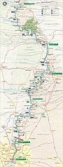
| Beskrivelse | Map of the Chesapeake and Ohio Canal National Historical Park — along the former Chesapeake and Ohio Canal between Cumberland, Maryland, and Washington, D.C., USA. |
| Dato | |
| Kilde | United States National Park Service, website for Chesapeake and Ohio Canal National Historical Park (http://www.nps.gov/choh/planyourvisit/parkmaps.htm). |
| Forfatter | National Park Service, US Department of the Interior. |
| Tilladelse (Genbrug af denne fil) |
Public domain - original work of the US Federal Government. |
Licensering
| This image or media file contains material based on a work of a National Park Service employee, created as part of that person's official duties. As a work of the U.S. federal government, such work is in the public domain in the United States. See the NPS website and NPS copyright policy for more information. |
Filhistorik
Klik på en dato/tid for at se filen som den så ud på det tidspunkt.
| Dato/tid | Miniaturebillede | Dimensioner | Bruger | Kommentar | |
|---|---|---|---|---|---|
| nuværende | 6. feb. 2007, 17:38 | 2.740 × 7.248 (6,8 MB) | Daderot | {{Information |Description=Map of the Chesapeake and Ohio Canal National Historical Park, along the former Chesapeake and Ohio Canal between Cumberland, Maryland, and Washington, D.C., USA. |Source=United States National Park Service, website for Chesapea |
Filanvendelse
Den følgende side bruger denne fil:
Global filanvendelse
Følgende andre wikier anvender denne fil:
- Anvendelser på de.wikipedia.org
- Anvendelser på en.wikipedia.org
- Anvendelser på fr.wikipedia.org
- Anvendelser på no.wikipedia.org
- Anvendelser på pl.wikipedia.org
- Anvendelser på zh.wikipedia.org
.jpg)