
Fil:D-day - British Forces during the Invasion of Normandy 6 June 1944 B5058.jpg

Fuld opløsning (793 × 800 billedpunkter, filstørrelse: 113 KB, MIME-type: image/jpeg)
|
|
Denne fil er fra Wikimedia Commons. Beskrivelsen af filen fra Commons er gengivet nedenfor. |
Beskrivelse
| Beskrivelse |
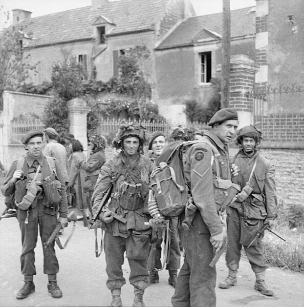
English: D-day - British Forces during the Invasion of Normandy 6 June 1944 Commandos of No. 4 Commando, 1st Special Service Brigade, and troops of 6th Airborne Division in Bénouville after the link-up between the two forces, 6 June 1944. |
|||
| Dato | mellem 1939 og 1945 | |||
| Kilde |
http://media.iwm.org.uk/iwm/mediaLib//48/media-48780/large.jpg
|
|||
| Forfatter | No 5 Army Film & Photographic Unit, Evans, J L (Capt) | |||
| Tilladelse (Genbrug af denne fil) |
This image was created and released by the Imperial War Museum on the IWM Non Commercial Licence. This image was catalogued as taken by the Army Film and Photographic Unit (AFPU) which operated between 1942—1946.[1] The AFPU was composed of members of the forces during their active service, so their works are covered by Crown Copyright provisions. Faithful reproductions may be reused under that licence, which is considered expired 50 years after their creation. | |||
| Part of | War Office Second World War Official Collection | |||
| Subjects |
|
|||
| Category | photographs | |||
| Image Sorted | yes |

| Kameraposition | | Dette og andre billeder på deres position på: OpenStreetMap |
|---|
Licensering
This image is in the public domain because it is a mere mechanical scan or photocopy of a public domain original, or – from the available evidence – is so similar to such a scan or photocopy that no copyright protection can be expected to arise. The original itself is in the public domain for the following reason:
This tag is designed for use where there may be a need to assert that any enhancements (eg brightness, contrast, colour-matching, sharpening) are in themselves insufficiently creative to generate a new copyright. It can be used where it is unknown whether any enhancements have been made, as well as when the enhancements are clear but insufficient. For known raw unenhanced scans you can use an appropriate {{PD-old}} tag instead. For usage, see Commons:When to use the PD-scan tag.  |

Filhistorik
Klik på en dato/tid for at se filen som den så ud på det tidspunkt.
| Dato/tid | Miniaturebillede | Dimensioner | Bruger | Kommentar | |
|---|---|---|---|---|---|
| nuværende | 17. mar. 2014, 09:55 | | 793 × 800 (113 KB) | Fæ | == {{int:filedesc}} == {{User:{{subst:User:Fae/Fae}}/IWM |description = {{en|''D-day - British Forces during the Invasion of Normandy 6 June 1944''<br/> Commandos of No. 4 Commando, 1st Special Service Brigade, and troops of 6th Airborne Division in B... |
Filanvendelse
Den følgende side bruger denne fil:
Global filanvendelse
Følgende andre wikier anvender denne fil:
- Anvendelser på en.wikipedia.org
- Anvendelser på es.wikipedia.org
- Anvendelser på he.wikipedia.org
- Anvendelser på pl.wikipedia.org
- Anvendelser på th.wikipedia.org
- Anvendelser på uk.wikipedia.org
- Anvendelser på www.wikidata.org